Floodsmart.gov The official site of the National Flood Insurance Program
![]()
Call toll free: 1-888-379-9531 or have us call you
A single heavy rain could cause you thousands of dollars in flood damage. Add coastal storm surge and wind-driven waves, and the results could be devastating. Be prepared for coastal weather and insure against rising water.
If asked to recall an overwhelming national disaster, you'll likely name a hurricane. People remember Isabel in 2003, Irene in 2011, Sandy in 2012, and other named storms for a reason: They caused widespread devastation and tens of billions of dollars in property damage. While most common along the Atlantic and Gulf coasts and in the Caribbean, hurricanes also form in the Pacific Ocean and affect the Hawaiian Islands.
Learn more about hurricanes and tropical storms.
The same cyclone patterns that cause hurricanes each summer and fall can bring equally devastating winter storms, known as Nor'easters, to the North Atlantic. The name comes from the direction the winds come from as blizzard-force snow and huge waves move onto the coast.
Learn more at the NOAA Nor'easter website.
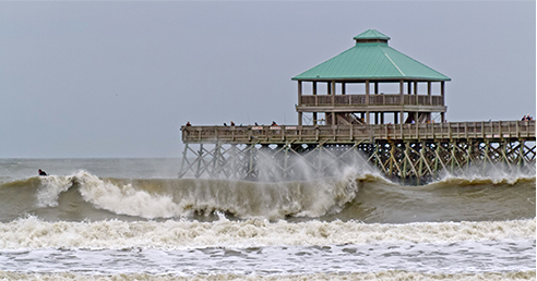
Storm surge occurs when a storm's winds push sea water toward the shore. The advancing surge combines with normal tides to create a hurricane storm tide, raising the average water level 15 feet or more. Storm surge can be hugely destructive. Sand dunes can be washed out, buildings near the coast can be toppled, and the surge can push flooding miles inland through rivers and back bays.
Learn more at the National Hurricane Center website.
A tsunami is a series of ocean waves typically caused by large, undersea earthquakes or by volcanic action. The waves travel at speeds up to 500 mph and can grow to massive heights when they crash on to the shore. While tsunamis occur most frequently in the Pacific Ocean, they can also strike the Atlantic coastline.
Learn more at the NOAA Tsunami website.
Lesser storms can also bring wave action that causes flooding, and waves can seriously erode natural barriers over time. Flood maps and flood insurance rates take wave effects into account by identifying VE zones, which are subject to wave heights of 3 feet or more. Buildings in these areas should be elevated using piers, posts, and pilings to protect against wave action. However, lesser wave heights can also be damaging to buildings along the coast. As new flood maps are released, they will show areas subject to waves of 1.5 feet or more.
Learn more about calculating wave action.
![]() Note: Adobe Reader is required to view PDF documents.
Download the Free Adobe Reader
Note: Adobe Reader is required to view PDF documents.
Download the Free Adobe Reader
What's My Flood Risk?
Visit FEMA's Flood Map Service Center to locate your flood map to help determine your flood risk.

500 C Street SW, Washington, D.C. 20472
Disaster Assistance: (800) 621-FEMA, TTY (800) 462-7585
U.S. Department of Homeland Security