Floodsmart.gov The official site of the National Flood Insurance Program
![]()
Call toll free: 1-888-379-9531 or have us call you
- Map Changes and Flood Insurance
- Newly Mapped Procedure
- Grandfathering
- Converting Your Policy
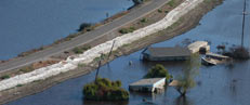
- Living Near a Levee
- Flood Map Update Schedule


Flood maps, known officially as Flood Insurance Rate Maps (FIRMs), show areas of high and moderate to low flood risk. Communities use the maps to set minimum building requirements for coastal areas and floodplains, lenders use them to determine flood insurance requirements, and the Federal Emergency Management Agency (FEMA) uses them to help determine what you should pay for flood insurance.
Flood maps show areas of high, moderate, and low flood risk as a series of zones. High-risk zones, also known as Special Flood Hazard Areas (SFHAs), begin with the letters “A” or “V.” Moderate- to low-risk zones, known as Non-Special Flood Hazard Areas (NSFHAs), begin with the letters “X”, “B” or “C.” There are also areas where the flood hazard is undetermined, labeled as Zone D. Learn more about defining flood risks, the risks shown on coastal flood maps, or the risks associated with living behind Levees.
View your map now at FEMA's Flood Map Service Center, or learn more about how flood maps affect your flood insurance rates.


What's My Flood Risk?
Visit FEMA's Flood Map Service Center to locate your flood map to help determine your flood risk.

500 C Street SW, Washington, D.C. 20472
Disaster Assistance: (800) 621-FEMA, TTY (800) 462-7585
U.S. Department of Homeland Security