Contacts
For more information, please contact:
Also available as Adobe PDF (286 KB)
PDF files can be viewed with the Acrobat® Reader®
The Federal Highway Administration’s (FHWA)’s Climate Resilience Pilot Program seeks to assist state Departments of Transportation (DOTs), Metropolitan Planning Organizations (MPOs), and Federal Land Management Agencies (FLMAs) in enhancing resilience of transportation systems to extreme weather and climate change. In 2013-2014, nineteen pilot teams from across the country partnered with FHWA to assess transportation vulnerability to extreme weather events and climate change and evaluate options for improving resilience. For more information about the pilots, visit: http://www.fhwa.dot.gov/environment/climate_change/adaptation/.

The Maine Department of Transportation (MaineDOT) pilot project dovetailed with a National Oceanic and Atmospheric Administration (NOAA)-funded Project of Special Merit (POSM) that studied the effect of sea level rise on marsh migration. Transportation assets may be a barrier to marsh migration or may be affected by marsh migration; the MaineDOT pilot identified specific transportation assets that are currently vulnerable to flooding, and leveraged the marsh and sea migration maps to assess the vulnerability of assets to storm surge and sea level rise. The project team applied a previously-developed infrastructure tool and modified it to be specific to transportation assets. The team used the Transportation-version of the Coastal Adaptation to Sea level rise Tool (T-COAST) to evaluate the benefits and costs of alternative design structures.
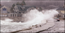
The assessment focused on state-owned roads, bridges, and culverts in the POSM’s six coastal study towns (Bath, Bowdoinham, Georgetown, Phippsburg, Scarborough, and Topsham). It evaluated vulnerability and adaptation options to sea level rise and storm surge.


Collect and process data. The project team gathered data on roads, bridges, and culverts in the six towns, including information on condition, emergency access, and regional importance. Sources of asset data included MaineDOT’s Bureau of Maintenance and Operations, Environmental Office, and Bureau of Planning. The Maine Geological Survey provided projections on future climate scenarios, including sea level rise scenarios developed based on both historic tide gauge data and inundation models.
To gain an initial understanding of vulnerability to sea level rise, the pilot team overlaid the transportation assets with the POSM’s Geographic Information System (GIS) maps of marsh and sea migration. The inundation maps created for the POSM were based on current sea level rise trends for 2100 of 0.7 feet, a moderate sea level rise projection of 3.3 feet, and a high projection of 6 feet.
Select assets in the six towns. The project team developed a Decision Support Tool (DST) to rank the criticality of road, bridge, or culvert data within a town in order to prioritize assets. The DST is designed to allow users to populate criteria such as the condition of each asset, its age, expected life, commerce loads, and other metrics of criticality and vulnerability. The user can weight the criteria, and then the DST ranks assets within each set to find the highest priorities for further analysis.
However, the pilot team adjusted the asset selection approach to manually select the highest priority asset instead of applying the DST. For each town, one critical asset was selected based on historical flooding reports (identifying structures with a history of flooding during a 100-year storm, which is roughly equivalent to 3.3 feet of sea level rise) and local expert knowledge. The approach was revised for several reasons: local knowledge about which assets were most vulnerable was easily obtainable given the limited scope within the six towns; in most towns, there was only one frequently flooded asset to rank; and the quality and availability of data to input into DST was quite variable. The project team focused in on critical assets in three of the six counties for further analysis based on their projected exposure to sea level rise and storm surge.
Develop adaptation design options and depth-damage functions. For each of three selected assets (one culvert and two bridges), MaineDOT bridge engineers developed adaptation design options for resiliency up to 3.3 feet and 6 feet of sea level rise and corresponding cost estimates (see Table 1 ). The pilot team also worked with the local engineers, maintenance crew, and maintenance records to create depth-damage functions specific to each asset and their adaptation options. Depth-damage functions describe the estimated repair cost for an asset at each flood elevation (see Figure 1 ).
Benefit-cost analysis. In order to estimate and compare the life-cycle costs of the replace-in-kind scenario with the adaptation options for each asset, the T-COAST tool was used to apply the depth-damage functions to the sea level rise and storm surge scenarios. Tool inputs included the depth-damage functions and sea level rise and storm surge parameters (e.g., sea level rise curves, storm surge elevations, recurrence intervals, and probabilities). The model output provided a matrix of expected total life-cycle cost estimates under the sea level rise and storm surge scenarios for the baseline and adaptation design options. The tool’s calculation of cost included the initial replacement or construction costs and the maintenance and repair costs after each storm surge event. The repair costs were calculated in today’s dollars. Benefits included avoided damages.
Vulnerability to sea level rise and storm surge. Upon closer analysis at the sites of the six asset candidates, three were not directly exposed to tidal action or storm surge. In Georgetown, Phippsburg, and Topsham, the critical assets with documented flooding histories were primarily subject to flows originating from uplands during storm events. The remaining three critical assets were carried forward to the adaptation analysis for sea level rise and storm surge.
Benefit-cost analysis of adaptation options. At each site, the design option with the lowest total life-cycle cost under each sea level rise scenario was deemed financially efficient (see Figure 2 ). Although the structures were exposed to the same sea level rise scenarios, the most financially efficient design option varied by site (see Table 2 ).
Furthermore, the analysis found that the majority of potential damage is from storm surge, not sea level rise. Approximately 77% of all cumulative damages for the baseline and adaptation options under all scenarios combined were from storm surge.

County |
Asset |
Most financially efficient design under 3.3 feet sea level rise scenario |
Most financially efficient design under 6 feet sea level rise scenario |
|---|---|---|---|
Scarborough |
Culvert |
Replace in-kind |
Replace in-kind |
Bath |
Bridge |
Replace in-kind |
Replace with a bridge designed for 6 feet sea level rise |
Bowdoinham |
Bridge |
Replace with a bridge designed for 6 feet sea level rise |
Replace with a bridge designed for 6 feet sea level rise |
Data-intensive tools are not always necessary. Data-intensive decision-making tools do not always provide definitive answers to questions of criticality and resiliency. The study intended to utilize and refine the DST and T-COAST. However, the pilot team did not find enough specific data about assets (e.g., scour critical information) to input into the DST. Furthermore, the small sample size of the assets in the towns meant that the team did not need to rank multiple critical assets. The project team adjusted their approach once they realized that a less data-intensive process would yield equal or better results.
There is no “one design standard fits all” adaptation option. The results indicate that local hydrology, topography, and tidal and storm surge regimes require a site-specific approach to benefit-cost analysis. The project team found that a “one design standard fits all” adaptation approach is unlikely because engineered adaptation design is specific to the site and structure.
Adopt a “no regrets” strategy. Adopting a “no regrets” strategy may increase resilience to storm surges and provide some allowance for sea level rise within a 20-year planning horizon. Such a strategy may be particularly useful where only a portion of an asset might be permanently affected or where an asset will only be affected during extreme weather events.
Focus on smaller infrastructure and incremental costs. Observations from the study indicate that under the ranges of likely scenarios, replacing structures so they are resilient to higher sea level rise in the study locations only became cost effective when either initial construction costs are relatively low or there was a combination of moderate construction costs and extreme sea levels. Therefore, smaller structures that require lower or moderate initial construction costs might be more cost-efficient in general.
The project team will be able to leverage the pilot data collection and analysis efforts in future work. For example, they can:
“Results also show that in terms of fiscal efficiency, there is no one right answer to the question ‘what design standard should we use?’ ” – MaineDOT Pilot Team
www.fhwa.dot.gov/environment/climate/adaptation/2015pilots/
Judy Gates
Environmental Office
Maine Department of Transportation
Judy.Gates@maine.gov, 207-624-3100
Becky Lupes
Sustainable Transport & Climate Change Team
Federal Highway Administration
Rebecca.Lupes@dot.gov, 202-366-7808