You are here
Taking on Frozen Debris Lobes—Permafrost Experts, DOT Engineers Team Up in First-of-its-Kind Study

Driving north on the highway from Cold Foot, Alaska, tourists and truckers pass mile 219 and look out their passenger window to see a giant mass of frozen debris inching slowly toward them. (Image: K. Powell, Anchorage Daily News)
The day-to-day challenges of researchers and engineers at the Alaska University Transportation Center (AUTC) and Alaska Department of Transportation and Public Facilities (DOT&PF) range from strengthening bridge foundations in the most seismically active state in America to relocating coastal communities that are literally being washed into the sea. Their latest challenge: how to keep a giant mass of frozen debris—a "frozen debris lobe" or FDL—from devouring portions of the Dalton Highway and the Trans-Alaska Pipeline.
The over 400-mile Dalton Highway is the only road to Alaska's North Slope oil fields, and the pipeline, which parallels it, carried an average of 600,000 barrels of oil per day in 2012. Driving north on the Highway from Coldfoot, Alaska, tourists and truckers alike passing mile 219 can look out their passenger windows to see "an elongated lobe of frozen soil, rock and debris" inching toward them.1 Trees have been ripped from their roots, toppled, and eventually consumed by the giant mass.

Trees have been slowly ripped from their roots, toppled, and eventually consumed by the slowly moving giant mass. Pictured: view of left flank of "FDL-A." (Photo: M. Darrow)
This FDL, called "FDL-A" by researchers, is more than 80 feet thick, with a toe that is 65 feet tall and 560 feet wide. Each day, the lobe moves an estimated 1,200 cubic feet of material toward the highway, roughly 22,000 tons per year. "Imagine a 50-ton truck dumping 440 truck-loads per year on the highway" and that's how much debris is moving, researchers explained in a recent publication.2 Now within 200 feet of the highway and moving at an average rate of 1 inch per day, this frozen landslide has the attention of State officials, and the Alaska DOT&PF, in partnership with the AUTC, quickly commissioned a preliminary study.
Fortunately, AUTC has a variety of civil engineering expertise housed within the Institute of Northern Engineering (INE). There some of the world's leading permafrost experts reside, including Margaret Darrow, assistant professor of geological engineering at the University of Alaska Fairbanks, and Ronald Daanen, assistant research professor with INE's Water and Environmental Research Center.
In the fall of 2012, a research group headed by Darrow and Daanen teamed-up with a drill crew from the Alaska DOT&PF to conduct two field investigation trips. In 2008, Daanen received a seed grant from Alaska EPSCoR3 to measure FDL-A's movement. This preliminary study resulted in the first publication on FDLs and established awareness of the current conditions and movement. The team had several goals: determine FDL-A's soil and bedrock profile; assess its thickness and stratigraphy; and install instruments and a weather station for measuring local weather, temperature, water pressure, and slope movement. They found that FDL-A was "fairly homogenous, consisting of silty sand with gravel."4 They drilled multiple borings and returned to conduct manual measurements and download meteorological data. On later trips, they also placed a series of GPS markers, enabling them to monitor FDL-A's biweekly movement. They have realized a variety of data, movement, and subsurface dynamics that have given rise to even more questions about the lobe.
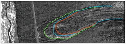
Now moving at an average rate of 1 inch per day, FDL-A has accelerated in recent decades. This figure shows its movement from 1955 (Red), 1979 (Blue), and 2008 (Green). (Figure: Daanen, et. al. 2012)
The State's recurring questions are "when will it reach the highway?" and "what can we do to stop it?" Solid answers are not yet clear. Since this study, theresearch team has expanded their inquiry to begin looking at similar FDLs in the region and to advance the scope and depth of data collection at FDL-A, which remains their primary concern. The team has expressed interest in gathering more temperature, water pressure, and slope movement data to discover any correlation between local weather/snow conditions and slope movement. This spring and summer, they returned to the field collecting additional movement measurements and plan more lab testing of samples from their initial work. Their broader goal is to conduct modeling of FDL-A to establish the geometry of the shear surface, the residual strength of the shear zone, and hopefully to assess mitigation strategies that the Alaska DOT&PF can use to counter FDL-A's movement toward the Dalton Highway. Such strategies will likely emerge from data that will eventually lead to more fully developed study conclusions. Until then, the lobe will continue to creep toward the highway and pipeline inch-by-inch, day by day.
What is an FDL?
For years, international experts politely disagreed over what to call such a phenomenon. It's not a glacier—but it has the dimensions and mass movement properties of a glacier. It's not a typical landslide either, yet it has plenty of soil and debris. And it is moving, slowly but steadily (FDL-A moved an average of 0.4 inches per day from 1955-2008a and is moving now at an accelerated rate of 1 inch per day).b Eventually, experts agreed on the term "frozen debris lobe" or FDL.
aDarrow, op. cit.
bDannen, op.cit.
1 Margaret M. Darrow, Ronald P. Daanen, and Jocelyn M. Simpson. Analysis of a Frozen Debris Lobe: A First Look inside an Impending Geohazard. Paper presented at the American Society of Civil Engineers, 10th International Symposium on Cold Regions Development, Anchorage, Alaska, June 5, 2013.
2 R. P. Daanen, G. Grosse, M. Darrow, T. D. Hamilton, and B. M. Jones, 2012. "Rapid Movement of Frozen Debris-Lobes: Implications for Permafrost Degradation and Slope Instability in the South-Central Brooks Range, Alaska." Natural Hazards and Earth System Science: 12, pp. 1-17, doi:10.5194/nhess-12-1-2012.
3 Experimental Program to Stimulate Competitive Research (EPSCoR) is program designed to fulfill the National Science Foundation's (NSF) mandate to promote scientific progress nationwide. The EPSCoR program is directed at jurisdictions that have historically received lesser amounts of NSF Research and Development (R&D) funding.
4 Darrow, Margaret M., Daanen, Ronald P., and Jocelyn M. Simpson. Analysis of a Frozen Debris Lobe: A First Look inside an Impending Geohazard. Paper presented at the American Society of Civil Engineers, 10th International Symposium on Cold Regions Development, Anchorage, Alaska, June 5, 2013.
About This Project
Margaret Darrow (mmdarrow@alaska.edu) is an associate professor of geological engineering at the University of Alaska Fairbanks. Ronald Daanen (rdaanen@alaska.edu) is an assistant research professor with INE's Water and Environmental Research Center (WERC). In addition to AUTC and Alaska DOT&PF's Statewide Research Section, researchers wish to thank Jocelyn Simpson, graduate student in geological engineering at UAF; the expertise, guidance, field, drilling and logistical support from Alaska