- About OST-R
- Press Room
- Programs
- Bureau of Transportation Statistics
- Intelligent Transportation Systems
- National Transportation Library
- Positioning, Navigation and Timing & Spectrum Management
- Research, Development and Technology
- Transportation Safety Institute
- University Transportation Centers
- Volpe National Transportation Systems Center
- Publications
- Library
- Contact Us
Detailed Justification for the Positioning, Navigation, and Timing (PNT) Program
Detailed Justification for the Positioning, Navigation, and Timing (PNT) Program
What Do I Need To Know Before Reading This Justification?
The Positioning, Navigation and Timing (PNT) Program is the sole means by which the Federal Government defines and implements civil sector PNT requirements. The Secretary of Transportation is assigned this role by National Security Presidential Directive, and includes all Federal, state and local government needs for GPS and its augmentations, as well as those of the private sector. The PNT Program is essential to ensuring that critical infrastructures have the primary and back-up PNT systems upon which they depend for daily operations, as well as identifying and pursuing gaps and research needed to meet these requirements, to enable future systems such as Next Gen, Positive Train Control, and Intelligent Transportation Systems (ITS).
DOT and DoD, in conjunction with 29 other departments and agencies, recently completed the National PNT Architecture Implementation Plan which identifies over 40 tasks to be accomplished to overcome capability gaps predominantly resulting from the limitations of GPS.
What Is The Request And What Will We Get For The Funds?
FY 2012 Positioning, Navigation, and Timing Program (PNT)
Budget Request
($000)
| Program Activity | FY 2010 Actual | FY 2012 Request | ChangeFY 2010-2012 |
|---|---|---|---|
| PNT Policy Coordination | 115 | 300 | 185 |
| National PNT Architecture | 275 | 650 | 375 |
| Civil GPS Service Interface Committee | 10 | 50 | 40 |
| Total | $400 | $1,000 | $600 |
The request is for $1M to enable DOT to serve as the lead for PNT requirements, architecture development, and GPS acquisition, development, and operations for all United States Government civil departments and agencies.
This program produces the Federal Radionavigation Plan, Civil PNT Requirements Document, chairs the Civil GPS Service Interface Committee, and advances the National PNT Architecture in conjunction with the Department of Defense and other government agencies to close identified PNT capability gaps and provide more efficient and effective capabilities.
| Key Actions | Key Outputs | Key Outcomes |
|---|---|---|
|
|
|
What Is This Program?
Strategic Goals: Safety and environmental sustainability.
Purpose/Beneficiaries: The purpose of this effort is to provide more effective and efficient PNT capabilities, and an evolutionary path for government-provided PNT systems and services. The beneficiaries of this effort are civil departments and agencies in the development, acquisition, management, and operations of GPS and other PNT services, and external users of government-provided PNT services.
Partners: RITA serves as the civil lead of the National PNT Architecture effort, a cross-modal interagency effort, to guide future PNT system-of-systems investment and implementation decisions. This effort is conducted through the DOT Pos/Nav Working Group and Executive Committee to coordinate with all modes within DOT. The DOT Extended Pos/Nav Working Group and Executive Committee is DOT's PNT coordination process with other civil agencies. The structure for this coordination process is shown in Figure 1.
Figure 1 Civil PNT Coordination Structure
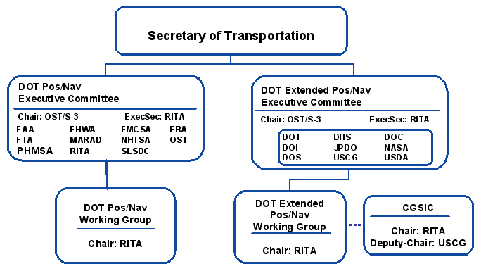
Description: The Positioning, Navigation, and Timing Program coordinates DOT PNT technology, policy, as well as provides civil PNT systems analysis which is critical to intermodal transportation applications in support of the DOT Strategic Goals. The program coordinates all civil sector PNT requirements and provides outreach to communities associated with PNT plans and policy.
A general description of the work of the program is provided below:
PNT Policy Coordination
- Provide support to the Deputy Secretary of Transportation and Under Secretary of Transportation for Policy with preparation of materials and briefings for their participation as the co-chairs of the Space-Based PNT Executive Committee and Executive Steering Group, respectively.
- Develop the Federal Radionavigation Plan (FRP) as directed by the National Defense Authorization Act for Fiscal Year 1998 (10 U.S.C. 2281(c)). The FRP is developed biennially by DOT in conjunction with DoD and DHS and is signed by the Secretaries of DOT, DoD, and DHS. The FRP reflects national policies and plans for U.S. government radionavigation systems and is used as a reference document both nationally and internationally.
- Provide a Civil PNT Requirements Document which serves as the foundation for the National PNT Architecture effort and allows program assessments to be performed to determine if the capabilities of the National PNT Architecture meet the needs of the civil community.
National PNT Architecture
- The National PNT Architecture is based on the fact that PNT is integral to the infrastructure on which the U.S. economy, national security and transportation systems rely. The architecture provides a time-phased, fiscally informed roadmap through 2025 of PNT activities, including needs for research and development.
Civil GPS Service Interface Committee (CGSIC)
- The CGSIC is the recognized worldwide forum for effective interaction between all civil GPS users and the U.S. GPS authorities. RITA chairs the CGSIC and the Coast Guard serves as Deputy Chair.
Prior Year Accomplishments:
- Address the issue of emerging low-cost GPS jammers from both a technical and regulatory standpoint. Work with the Department of Homeland Security (DHS) on a GPS threat assessment for transportation applications of GPS, as well as a National Risk Assessment for applications of GPS.
- Release of the 2011 DOT Spectrum Plan. RITA will also participate in the Interagency Radio Advisory Committee and represent the DOT position in proceedings involving other agencies such as the Federal Communications Commission and the National Telecommunications and Information Administration of the Department of Commerce.
- Development of the draft of 2012 Federal Radionavigation Plan.
- Assessment of research and develop efforts as identified in the National PNT Architecture Plan.
Why Is This Particular Program Necessary?
The National Security Presidential Directive on Space-Based Positioning Navigation and Timing Policy gives the Secretary of Transportation broad responsibilities in providing for and implementing PNT services for the civil community. This policy ensures that the U.S. maintains space-based positioning, navigation, and timing services, augmentation, back-up, and complementary capabilities. Positioning, Navigation, and Timing capabilities are critical for the Next Generation Air Transportation System, Intelligent Transportation Systems, and Positive Train Control. In 2001, the Volpe Center released a study entitled Vulnerability Assessment of the Transportation Infrastructure Relying on the Global Positioning System http://ntl.bts.gov/lib/31000/31300/31379/17_2001_Volpe_GPS_Vulnerability_Study.pdf
In the nine years since that study was released, little has been done to implement solutions that address these vulnerabilities.
DOT, as the lead civil agency for PNT, has the opportunity to continue to partner with the Department of Defense to advance research on alternative PNT technologies that can be integrated with GPS to meet multiple user needs as identified in the National PNT Architecture Implementation Plan. This allows for long range planning through 2025 and the ability to make informed decisions on PNT capabilities based on solid technical and cost information.
How Do You Know the Program Works?
Before the National PNT Architecture effort was formed, the U.S. Government had an ad hoc approach to developing and providing PNT capabilities. There was no coordinated research, duplication of efforts, and capability gaps that no agency was addressing. There also was little recognition of the synergies of PNT needs across civil, military, and homeland security communities. These are identified the National PNT Architecture Study Report from 2008. http://ntl.bts.gov/lib/31000/31300/31341/06_2008_National_PNT_Architecture_Study_Final_Report.pdf.
The National PNT Architecture effort works because it recognizes that PNT is integral to the infrastructure on which the U.S. economy, national security and transportation systems rely.
DOT and DOD, in conjunction with 29 other departments and agencies, recently completed the National PNT Architecture Implementation Plan which identifies tasks to be accomplished to overcome capability gaps resulting from the limitations of GPS.
Why Do We Want/Need To Fund The Program At The Requested Level?
USDOT requires funds at the requested level to fulfill its responsibilities as the lead civil agency for PNT. Technical and cost analysis is needed for the Department to make informed decisions on alternative sources of PNT to integrate with GPS.
History of PNT Funding and Out Year Needs: FY 2010 $.400M; FY 2012 $1M.