Project spotlight: Memorial Bridge
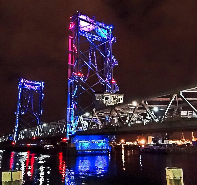 US Route 1 is a principal urban arterial, connecting Portsmouth’s business district in New Hampshire with Badger’s Island in the Town of Kittery, Maine. The Memorial Bridge is the only bicycle and pedestrian connection between NH and ME in the region and is located in the heart of downtown Portsmouth flanked by residential, cultural and recreational uses in both states. The bridge has been an important crossing since 1923 and provides a multi-modal transportation link that has enhanced trade and commerce, tourism and the community life shared by these two towns. The bridge had a sufficiency rating of 6 out of 100, and safety concerns resulted in both states’ restricting bridge traffic to no more than three tons, thereby causing all truck traffic to detour. The TIGER II grant provided by the U.S. Department of Transportation enabled this bridge to resume normal operations.
The project’s community involvement is like no other that NH DOT had worked on. Right from the start, the local community wanted to be intimately involved throughout the Design-Build process and, as such, developed a strong partnership between project proponents and the general public. NHDOT organized a Public Outreach Committee consisting of City, town and public members to engage in constructive input on the design and construction phase of the project. The Department hired a Public Outreach Coordinator (POC) with experience in Complete Street and Main Street projects to lead this effort under the direct supervision of the NHDOT Project Manager. This Outreach group was instrumental in forging community support and project enhancements, such as pedestrian bump-outs, shuttle service during construction, and bridge aesthetic illumination. This required daily interaction with the public and media, as well as, facilitation of events and communications concerning construction-based impacts on the economic viability of downtown businesses and cultural sites.
The outreach for the project also included working with the local schools education program for math, science and languages. The project proponents went to several seacoast schools to assist them with their interest in the engineering aspects of the project. The local newspapers throughout the project life had daily reporting on the project. The old bridge had emphasized the critical importance this bridge plays within the seacoast area for not only the transportation network but the general community cohesion. This could be seen by the excitement of the opening celebration in August especially with the bridging of generations and connecting communities. Local resident Eileen Foley, who cut the ribbon on the original bridge in 1923, brought the community together to cut the ribbon on the reopening in August of 2013.
Project spotlight: CREATE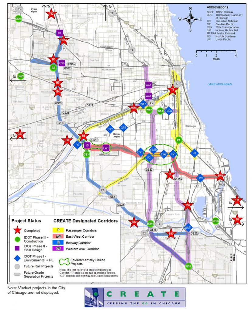
Chicago is the largest rail hub in the country with more than 1,200 trains passing through it daily carrying 75 percent of the Nation's freight by tonnage that is valued at $350 billion. Over 37,500 rail freight cars pass through the City every day; a figure which is projected to increase to 67,000 by 2020. Moving this freight through Chicago creates a host of conflicts on the freight rail system and between freight rail and commuter rail, intercity passenger rail, automobiles, bicycles, and pedestrians.
The Chicago Region Environmental and Transportation Efficiency Program, known as “CREATE”, is a first-of-its-kind partnership among U.S. DOT, the State of Illinois, the City of Chicago, Metra (the region’s commuter rail agency), Amtrak, and the Nation's largest freight railroads. The approximately $1.5 billion program includes 70 projects that will restructure, modernize and expand existing rail facilities to improve freight and passenger mobility in and through Chicago while reducing negative environmental and social impacts.
CREATE received a TIGER grant of $100 million to complete five of the top priority projects in their pipeline. The grant leveraged $14 million in State and local funding and $48 million in funding from the private railroads. Collectively the five projects will add capacity and reduce delays for freight and commuter trains, reduce delays to motorists using at-grade crossings, as well as improve roadways, sidewalks, and curbs under railroad viaducts to enhance safety and security for motorists, bicyclists, and pedestrians.
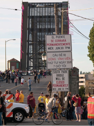 Project spotlight: South Park Bridge
TIGER has consistently focused on the condition of our Nation’s bridges, including large projects that State and local governments have trouble funding. While there are many examples of bridges around the country that are deteriorating and in great need of repair, DOT invests its limited TIGER funds in bridges that not only exhibit acute need, but also demonstrate substantial State and local support for repair, and incorporate broad multi-modal goals in their design and reconstruction.
King County, Washington, sought funds in the first round of TIGER to replace the South Park Bridge—one of only two river crossings on the high-traffic freight and commuter corridor south of Seattle—in order to avoid its forced closure for safety concerns. While the application was compelling, relying on the bridge’s most recent sufficiency rating of 4 (out of 100), King County was ultimately not successful in the first round of TIGER. After missing out on the TIGER award, King County closed the South Park Bridge for safety reasons.
However, in the next round of TIGER, King County presented an exceptionally broad coalition of partners and funding commitments, including the Cities of Seattle and Tukwila, the State of Washington, the Port of Seattle, the Puget Sound Regional Council, and private companies. Financial commitments from these partners totaled $94 million or 72 percent of the $130 million construction cost. DOT awarded the South Park Bridge Replacement a TIGER grant to complete the funding package and restore this vital bridge, strengthening economic competitiveness for the region while improving commuter connectivity and reducing congestion.
Project spotlight: Atlanta Streetcar
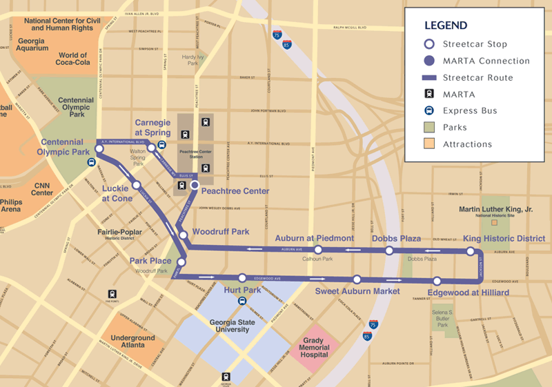
The Atlanta Streetcar project is a product of the relationship between the city, the business community, and MARTA, the local transit authority. The project received a $47.6 million TIGER grant to construct a new east-west streetcar line connecting many of the residential, cultural, educational and historic centers downtown, which will improve Atlanta’s quality of life and provide enhanced transit options in a major metropolitan area.
The project, which connects to the existing MARTA rail system at Peachtree Center, includes 2.7 miles of track and four streetcars that will operate between 12 stations. The streetcars will travel counter clockwise along a loop providing service to more than 7,000 residents living within a quarter mile of the streetcar, as well as more than 4.7 million tourists and 1.3 million conventioneers who visit downtown Atlanta annually. Additionally, students of Georgia State University and patients seeking healthcare services from Grady Memorial Hospital and Children’s Healthcare of Atlanta will have a new, additional travel option.
When completed, the streetcar will provide residents, students and visitors with easy access to jobs and public amenities in the core of downtown Atlanta without having to fight traffic. Located within an economically distressed area, the project will help spur new pedestrian-oriented development, support mixed-use projects, and reinforce development plans. It will also reconnect the eastern and western sections of downtown, which have been separated since Interstate 75/85 was built in the 1950s.
Project spotlight: US-491 Safety Improvements
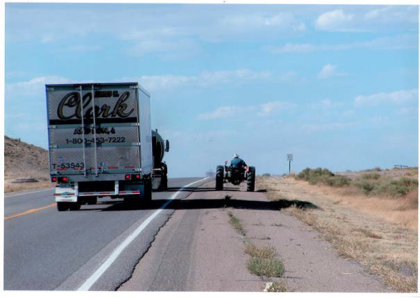 US-491 is the primary north-south highway in an extremely rural area of northwest New Mexico. The road connects the local Navajo Nation to other parts of New Mexico, Colorado, and the Four Corners area. It is a major trucking route with increasingly high volumes of commercial traffic. However, the road has a history of traffic accidents and safety problems. The fatality rate at the north portion of the corridor is about 3.6 times the state average, and at the south portion, about 2.2 times the average state rate.
TIGER is funding a portion of the full project, which will expand the width of US-491 over a corridor length of approximately 69 miles, providing two additional lanes and separating north-and south-bound traffic with a 46-foot median. Additional safety improvements include constructing turn lanes for acceleration and deceleration in commercial and high-traffic areas, and improving intersections, signage, markings and drainage facilities. The project is expected to improve safety, increase transportation efficiency, and create potential economic development opportunities for the Navajo Nation and the state of New Mexico.
Project spotlight: California’s Green Trade Corridor
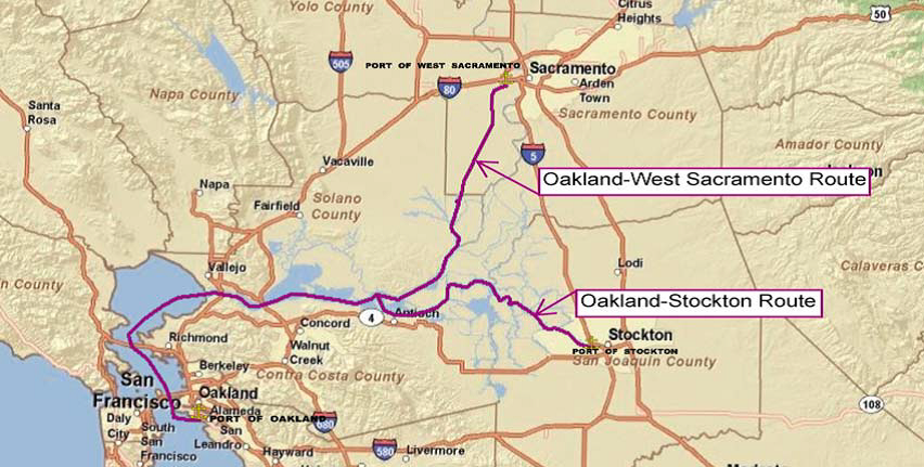
The Port of Oakland currently functions as the nation’s fifth busiest container port, loading and discharging 99 percent of containerized goods for Northern California’s imports and exports. Ninety percent of the commodities headed for Oakland’s ports and the San Francisco Bay Area from the Sacramento Central Valley region currently travel by truck along congested highways, through areas with impacted air quality. With the help of TIGER funding, California’s Green Trade Corridor Marine Highway project will significantly improve energy efficiency while also strengthening the region’s economic competitiveness.
The Green Trade Corridor creates an innovative marine highway to deliver consumer goods and agricultural products via barge between the Port of Oakland and the Ports of Stockton and West Sacramento, as well as implementing a GHG reduction system for ships docked at the Port of Oakland. Barge [emissions] rates are half as low as rail and nearly 95 percent lower than trucks, have fuel-efficiency more than double that of rail and nine times that of truck, and are the safest mode of transport. Shifting transit modes for products to barge significantly reduces oil dependence and GHG emissions. Additionally, removing trucks from Central California’s essential highways will reduce traffic for the traveling public and wear and tear on the roadways, and lower overall maintenance costs.
 Project spotlight: DOT-HUD Planning Grants
DOT, HUD and EPA created the Partnership for Sustainable Communities to encourage interagency cooperation and assist all three agencies in investing limited Federal resources in projects that are well-coordinated and planned. The Partnership for Sustainable communities established Six Livability Principles to guide collaboration and inform the joint planning grant process.
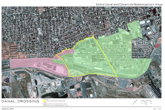
Jersey City, New Jersey, proposed a transformative 111-acre redevelopment of the Canal Crossing former industrial sites using EPA’s LEED-Neighborhood Development (LEED-ND) principles. DOT and HUD will jointly fund $1.9 million of the $2.8 million planning cost to anticipate redevelopment of over 30 brownfield sites, enabling Jersey City to prepare the area to support transit-oriented developments with a mix of businesses and housing. The redevelopment will establish links to the regional rail network and support affordable housing and transportation choices to strengthen the area’s economic competitiveness and residents’ access to jobs in a community experiencing high unemployment and poverty rates.
In Oakland, California, DOT will fund planning activities for a massive redevelopment of 1,800 acres in support of significant community efforts to reuse the former Oakland Army Base. Oakland’s Infrastructure Master Planning will direct utility and roadway improvements and also include Transit-Oriented Development around the West Oakland Station – the busiest on the Bay Area Rapid Transit line. DOT’s $2 million investment in support of the City’s $9 million planning project will enable Oakland to capitalize on the existing infrastructure left under-utilized by the base’s 1999 closure and create more transportation options to link new housing and employment areas.
Project spotlight: I-95 HOT Lanes
 The Virginia Department of Transportation (VDOT) is utilizing a $20 million TIGER TIFIA payment to leverage a much more robust TIFIA loan to help finance the construction of 29 miles of High-occupancy Toll (HOT) lanes in Northern Virginia, from Fairfax to Stafford Counties. The northern portion of the new HOT lanes will connect with the Capital Beltway HOT lanes that are currently under construction. The lanes will incorporate state-of-the-art variable pricing to assure a quality service level for users. The project is being delivered as a PPP featuring $550 million in private equity and $50 million in VDOT funding. In addition to design, construction, and project financing, the concessionaire is assuming long-term operations and maintenance responsibilities.
This project will provide regional commuters with an option to bypass congestion on I-95 general-purpose lanes. The new HOT lanes will improve the reliability of vehicles and transit service along the corridor. Together, this will improve traffic conditions on the general-purpose lanes while reducing fuel consumption and associated emissions.
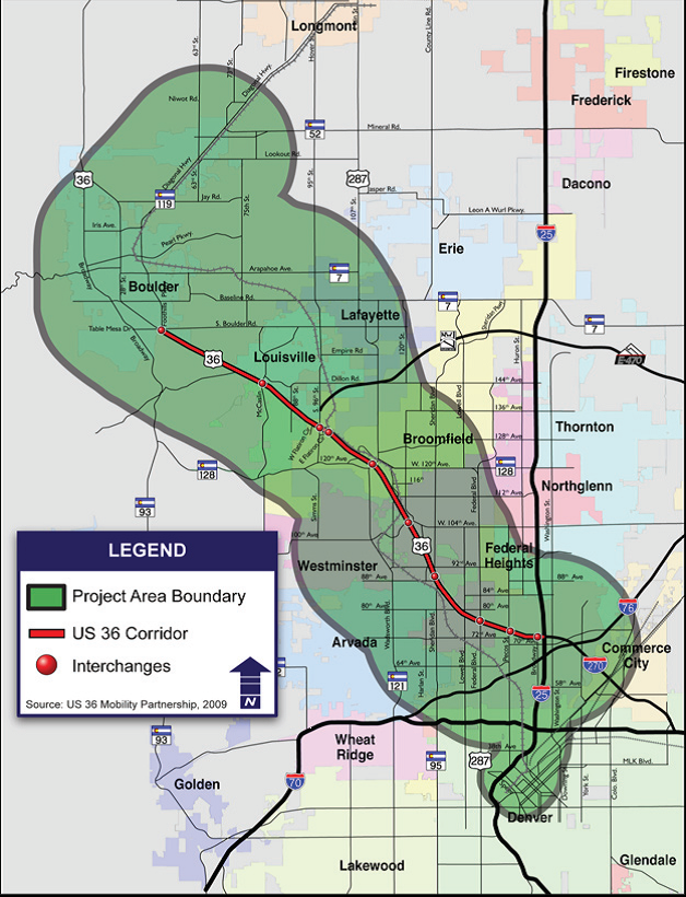 Project spotlight: U.S. 36 Managed Lanes/Bus Rapid Transit
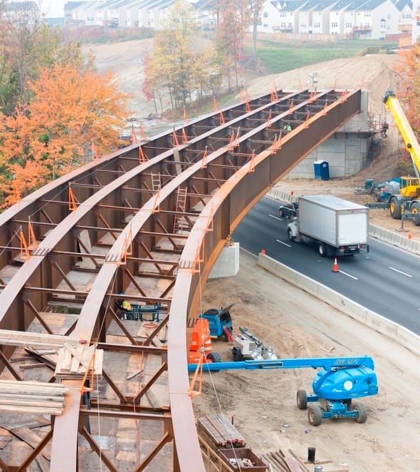
The first project to successfully leverage a TIGER TIFIA Challenge Grant is the U.S. 36 Managed Lanes/Bus Rapid Transit Project in Colorado. The project will add one managed lane in each direction along the first 10 miles of the U.S. 36 corridor as it leaves Denver heading northwest towards Boulder. The managed lanes will provide a congestion free alternative for peak period motorists paying a toll and will connect to other regional express lanes on I-25. The regional bus rapid transit system will have free access to the managed lanes and new, more frequent bus service will be provided. The general purpose lanes will be reconstructed and a commuter bikeway will be added. This innovative approach to managing demand on a congested highway corridor is gaining momentum in jurisdictions around the United States because it is expected not only to alleviate congestion by better managing demand, but also to provide better commuting options for transit riders, bicyclists, and other non-drivers.
With their $10 million TIGER TIFIA Challenge Grant, Colorado worked with DOT to complete an investment grade traffic and revenue study and to pay the costs of a $54 million TIFIA loan. Colorado was able to use the TIFIA loan to anchor the other elements of a robust $307 million financing package that includes a broad mix of State, local and Federal funds. The division of the Colorado DOT charged with delivering this project, the “High Performance Transportation Enterprise”, expects to award a design-build contract this spring to ensure that the project is delivered on time and budget. The project will be complete in 2015.
Not only did the TIFIA Challenge Grant help facilitate a more robust TIGER project on U.S. 36 than could have been achieved with a $10 million grant, but it has also created momentum for Colorado’s procurement of the next phase of the project, extending the lanes eight additional miles to Boulder.
While the TIGER-funded portion of the project is being procured as a design-build project, the Colorado DOT expects to structure the next phase as a more robust PPP with the private sector concessionaire responsible for design, construction, financing, operation and maintenance of the project. The concessionaire may also assume responsibility for the operation and maintenance of the first phase of the project and Denver’s I-25 Express Lanes, which connect to the southern end of the U.S. 36 corridor. This would allow for enhanced coordination of all of these elements of the regional managed lanes network.
The U.S. 36 project demonstrates what programs like TIGER can do when given the opportunity to build on the best practices developed through DOT’s existing credit assistance and discretionary programs. TIGER can provide a more robust and effective mechanism for investing Federal funds and attracting substantial private sector co-investment to help deliver some of our Nation’s most challenging and complex transportation projects.