


USDOT Launches Geographical View of National ITS Deployment
The USDOT is launching the first-ever ITS Asset Viewer at the Intelligent Transportation Society of America (ITS America) Annual Meeting and Exposition from April 22 to 24, 2013, in Nashville, TN.
USDOT Presence at the First Annual Global Symposium on Connected Vehicles and Infrastructure
Read Article...
QUESTIONS?
At the Research and Innovative Technology Administration, we are committed to providing information and engaging new and existing stakeholders throughout the research process. If you have questions about our
programs, please contact Mike Pina at
mike.pina@dot.gov
Thank you for your interest in the DOT's ITS program.
STAY CONNECTED
![]()
UNSUBSCRIBE
Please take me off the email list for this newsletter.
USDOT Announces 2013 Road Weather Management Stakeholder Meeting
Read Article...
USDOT Launches a Transportation Data-Sharing System
Read Article...
USDOT to Host a Connected Vehicle Reference Implementation Architecture (CVRIA) Workshop
Read Article...
USDOT Presence at 2013 ITS America Annual Meeting
Read Article...

USDOT Launches Geographical View of National ITS Deployment
The USDOT is launching the first-ever ITS Asset Viewer at the Intelligent Transportation Society of America (ITS America) Annual Meeting and Exposition from April 22 to 24, 2013, in Nashville, Tennessee. The ITS Asset Viewer visually displays the location of ITS deployments nationwide, providing a geographic picture of the status of ITS deployment.
The ITS Asset Viewer complements the USDOT’s ITS Deployment Tracking Survey, developed for the ITS JPO by Oak Ridge National Laboratory. Conducted 10 times since 1997, the survey measures the extent of ITS deployment within 108 metropolitan areas across the United States. The survey helps guide federal ITS research and program management, inform Congress, and assess the cost and operational impact of ITS at the national scale. However, the survey focuses on the quantity of ITS deployment, not their locations within the metropolitan area.
With the advancement of the use of GIS for state asset management, it is now possible to assemble a national database of ITS assets with accurate locations along the Interstate system. The project team launched an effort to gather GIS data from each state department of transportation and assembled the resulting data from a variety of formats into a cohesive picture of national ITS deployment. The viewer visually presents the GIS data from the states (46 states have responded thus far) regarding key ITS technologies such as cameras, messages signs, ramp meters, speed sensors, and roadway weather information systems. Currently, there are over 75,000 assets in the database, and it is expected to grow as the remaining states provide information.
Researchers, agencies, and the public at large will benefit from this new data resource and platform for analysis. The deployment of ITS technology can now be integrated with other geospatial information such as evacuation routes, major commercial truck routes, and interstate corridors. Other USDOT resources such as the data from the Highway Performance Monitoring System can also be integrated to support various analyses. State agencies will be able to get a picture of how other states have deployed assets to address operational needs, such as along major arterials or around special event venues. The information can also help to correlate ITS deployment with traffic volume or average speed and determine where deployment gaps may exist. “Combining volume, speed, and treatment types opens the lid for all new types of analyses,” notes David Schrank of the Texas Transportation Institute.

The USDOT expects that the nationwide launch of the viewer will encourage other cities, states, and toll agencies to provide their ITS data for inclusion. There are plans to build new functionality into the ITS Asset Viewer to support reports, data downloads, or access via web services, including mechanisms to allow agencies to update their ITS deployment data easily. The result will be a more comprehensive and detailed map of ITS deployment nationwide.
Visit http://www.its.dot.gov/assetviewer.

USDOT Presence at the First Annual Global Symposium on Connected Vehicles and Infrastructure
May 14 – 16, 2013, University of Michigan North Campus Research Complex, Ann Arbor, MI
National Highway Traffic Safety Administration (NHTSA) Administrator David Strickland and ITS JPO Director Ken Leonard will be speaking at the first Global Symposium on Connected Vehicles and Infrastructure, to be held in Ann Arbor, MI, from May 14 to 16, 2013. The event is taking place at the site of the USDOT's Connected Vehicle Model Deployment, the largest deployment of vehicle-to-vehicle and vehicle-to-infrastructure technology in the world, with almost 3,000 connected cars, freight trucks, and transit buses. Other USDOT speakers include Steven Wood (NHTSA), Daniel Smith (NHTSA), Timothy Johnson (NHTSA), and Carl Andersen (Federal Highway Administration).

USDOT Announces 2013 Road Weather Management Stakeholder Meeting
The Federal Highway Administration (FHWA) will be sponsoring its annual Road Weather Management Stakeholder Meeting on July 16-18, 2013, in Little Rock, Arkansas. The meeting provides a venue for peer exchange between the transportation and weather community, consisting of state departments of transportation (DOTs), academia, vendors, weather service providers, and consultants.
This year, the meeting will focus on road weather connected vehicle research for maintenance activities, traveler information, and traffic management centers, as well as strengthening the working relationships between state DOTs and the weather enterprise. Other key topics will include updates on Clarus, MADIS (Meteorological Assimilation Data Ingest System), and the Weather Data Environment; weather-responsive traffic management; and other road weather management projects being conducted by FHWA and its stakeholders/partners throughout the country.
The meeting will include presentations, facilitated discussions, and networking opportunities for all participants.

USDOT Launches a Transportation Data-Sharing System
The USDOT's Research and Innovative Technology Administration and Federal Highway Administration have released the first version of the Research Data Exchange (RDE), a transportation data-sharing system that promotes sharing of archived and real-time data from multiple sources and multiple modes. This new data-sharing capability will support the needs of ITS researchers and developers while reducing costs and encouraging innovation. Data accessible through the RDE is quality checked, well documented, and available to the public.
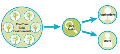
There are nine data environments in the RDE, with more on the way. Each data environment has multiple data sets and standards-based metadata. The nine data environments include:
- Three sets of trials of connected vehicle technology (onboard equipment sending probe messages to roadside equipment) conducted from 2008 through 2010 at the USDOT's Connected Vehicle Michigan Test Bed, plus data from a detailed simulation of the test bed area.
- Two sets of data collected in Orlando, FL, and Leesburg, VA, from vehicle awareness devices that record vehicle position, heading, speed, and acceleration every 0.1 second in the format of a standard Basic Safety Message.
- One year of freeway volume, occupancy, and speed data from San Diego, CA, including incident reports, weather reports, and sample GPS vehicle location data vehicle tracks.
- Two months of freeway and arterial data from Portland, OR, including arterial travel times, signal timing plans, freeway incidents, weather reports, and transit stops.
- Six months of freeway and arterial data from Seattle, WA, including freeway and arterial travel times, incident and message sign data, signal timing plans, weather reports, and transit stops.
- Two months of detailed freeway and arterial data from Pasadena, CA, including simulated link volumes, capacities, and delays; incident, work zone, and message sign data; signal timing plans; weather reports; and closed-circuit TV (CCTV) snapshots every minute.
Each of these data environments consists of multiple data sets and supporting metadata files. Additional data environments will be created as data become available from projects related to the connected vehicle program, whether or not they are funded by USDOT.
Users may browse through the data environments or use an advanced search capability to find data sets that contain specific types of information. Registered users may download data files, post comments about the files, and define projects to share information and collaborate with other users. The website also contains Frequently Asked Questions (FAQs) and links to related ITS websites.
The RDE can be found online at https://www.its-rde.net.

USDOT to Host a Connected Vehicle Reference Implementation Architecture (CVRIA) Workshop
The USDOT is hosting a CVRIA workshop from April 30 to May 1, 2013, to gain important feedback from stakeholders in the manufacture, development, deployment, operation, or maintenance of connected vehicle technologies and applications. Connected vehicles will leverage wireless technology to enable communication among vehicles, roadside infrastructure, and personal mobile devices and maximize safety, mobility, and environmental performance. The CVRIA workshop will discuss and solicit feedback on preliminary system architecture viewpoints for the technologies and applications within the connected vehicle environment.
Successful implementation and operation of a connected vehicle environment will require vendors and implementers to understand where standards will be needed, and planning for deployment of the new technologies and applications will require guidelines for using the new connected vehicle elements within the National ITS Architecture. To identify such standards and develop guidelines, a set of system architecture viewpoints must be developed that describe the functional, physical, and logical interfaces; enterprise relationships; and communications dependencies for each technology and application within the connected vehicle environment. These viewpoints will result in a CVRIA, which will form the basis for integrating the connected vehicle environment into the National ITS Architecture and provide the interface information needed for standardization planning.

USDOT Presence at 2013 ITS America Annual Meeting
Connected Vehicle 101 Workshop
Sunday, April 21, 12:30 p.m. - 3:30 p.m.
How We Pay for Maintaining and Improving Transportation Infrastructure
Monday, April 22, 2:00 p.m. – 3:15 p.m.
INVITED SPEAKERS: Polly Trottenberg, Under Secretary for Policy, USDOT
Transformative Innovations: Connected Vehicles and Beyond
Monday, April 22, 3:45 p.m. – 5:00 p.m.
INVITED SPEAKERS: Mike Schagrin, Program Manager, Connected Vehicle Safety & Automation, ITS Joint Program Office, Research and Innovative Technology Administration (RITA)
SS06: Integrated Corridor Management (ICM) Demonstrations Go Live
Monday, April 22, 3:45 p.m. – 5:00 p.m.
USDOT Programs Update
Tuesday, April 23, 8:00 a.m. – 9:00 a.m.
MODERATOR: Greg D. Winfree, Deputy Administrator, RITA
SPEAKERS:
David Strickland, Administrator, National Highway Traffic Safety Administration
Victor Mendez, Administrator, Federal Highway Administration (FHWA)
Bill Bronrott, Deputy Administrator, Federal Motor Carrier Safety Administration
Ken Leonard, Director, ITS JPO
SS19: USDOT National ITS architecture and Connected Vehicle Reference Implementation Architecture (CVRIA) Program Updates
Tuesday, April 23, 3:45 p.m. – 5:00 p.m.
TS03: Weather Management
Tuesday, April 23, 9:00 a.m. – 10:15 a.m.
11443: Developments in Weather Responsive Traffic Management Strategies (Ray Murphy, FHWA)
TS04: Deployment Tools and Lessons
Tuesday, April 23, 9:00 a.m. – 10:15 a.m.
11325: Cyber Security in Highway/Roadway: The Roadmap to Secure Control Systems in the Transportation Sector (David Sawin, Volpe National Transportation Systems Center)
SS28: Connected Vehicle: Vehicle-to-Vehicle Safety Pilot and Model DeploymentWednesday, April 24, 9:30 a.m. – 10:45 a.m.