


NHC Tropical Cyclone Text Product Descriptions
Download the NHC Product Description User's Guide for all tropical cyclone-related products.
Contents
- TC Public Advisory (TCP)
- TC Forecast/Advisory (TCM)
- TC Forecast Discussion (TCD)
- TC Wind Speed Probabilities (PWS)
- TC Update (TCU)
- TC Position Estimate (TCE)
- Tropical Weather Outlook (TWO)
- TC Valid Time Event Code (TCV)
- TC Aviation Advisory (TCA)
- Hurricane Local Statement (HLS)
- Monthly TC Weather Summary (TWS)
- Tropical Cyclone Reports (TCR)
Tropical Cyclone Public Advisory (TCP) - How to Read
World Meteorological Organization (WMO) and AWIPS (in parenthesis) headers:WTNT31-35 KNHC (MIATCPAT1-5) – Atlantic
WTPZ31-35 KNHC (MIATCPEP1-5) – E. Pacific
The Tropical Cyclone Public Advisory contains a list of all current watches and warnings on a tropical or subtropical cyclone. It also gives the cyclone position in terms of latitude and longitude coordinates and distance from a selected land point or island, as well as the current motion. The advisory includes the maximum sustained winds in miles per hour and the estimated or measured minimum central pressure in millibars and inches. The advisory may also include information on potential storm tides, rainfall or tornadoes associated with the cyclone, as well as any pertinent weather observations.
Public advisories are issued for all Atlantic and eastern Pacific tropical or subtropical cyclones.
Public advisories for Atlantic tropical cyclones are normally issued every six hours at 5:00 AM EDT, 11:00 AM EDT, 5:00 PM EDT, and 11:00 PM EDT (or 4:00 AM EST, 10:00 AM EST, 4:00 PM EST, and 10:00 PM EST).
Public advisories for Eastern Pacific tropical cyclones are normally issued every six hours at 2:00 AM PDT, 8:00 AM PDT, 2:00 PM PDT, and 8:00 PM PDT (or 1:00 AM PST, 7:00 AM PST, 1:00 PM PST, and 7:00 PM PST).
Intermediate public advisories are issued every 3 hours when coastal watches or warnings are in effect. Additionally, special public advisories may be issued at any time due to significant changes in warnings or in the cyclone.
The numbers 1-5 in the headers are assigned on a rotating basis by cyclone number, i.e., advisories on the first, sixth, or eleventh cyclones of the Atlantic season would be sent under the WMO header WTNT31 KNHC; advisories on the second, seventh, or twelfth cyclones of the Atlantic season would be sent under the WMO header WTNT32 KNHC, and so on.
See Example
Tropical Cyclone Forecast/Advisory (TCM) - How to Read
World Meteorological Organization (WMO) and AWIPS (in parenthesis) headers:WTNT21-25 KNHC (MIATCMAT1-5) – Atlantic
WTPZ21-25 KNHC (MIATCMEP1-5) – E. Pacific
The Tropical Cyclone Forecast/Advisory contains a list of all current watches and warnings on a tropical or subtropical cyclone, as well as the current latitude and longitude coordinates, intensity, and system motion. The advisory contains forecasts of the cyclone positions, intensities, and wind fields for 12, 24, 36, 48, and 72 hours from the current synoptic time. The advisory may also include information on any pertinent storm tides associated with the cyclone. All wind speeds in the forecast advisory in given in knots (nautical miles per hour).
Forecast/Advisories are issued on all Atlantic and eastern Pacific tropical and subtropical cyclones every six hours at 0300, 0900, 1500, and 2100 UTC (learn about UTC time). Special Forecast/Advisories may be issued at any time due to significant changes in warnings or in the cyclone.
The numbers 1-5 in the headers are assigned by cyclone number, i.e., advisories on the first, sixth, or eleventh cyclones of the Atlantic season would be sent under the WMO header WTNT21 KNHC; advisories on the second, seventh, or twelfth cyclones of the Atlantic season would be sent under the WMO header WTNT22 KNHC, and so on.
See Example
Tropical Cyclone Discussion (TCD)
World Meteorological Organization (WMO) and AWIPS (in parenthesis) headers:WTNT41-45 KNHC (MIATCDAT1-5) – Atlantic
WTPZ41-45 KNHC (MIATCDEP1-5) – E. Pacific
The Tropical Cyclone Discussion explains the reasoning for the analysis and forecast of a tropical or subtropical cyclone. It includes a table of the forecast track and intensity.
Tropical Cyclone Discussions are issued on all Atlantic and eastern Pacific tropical and subtropical cyclones every six hours. Special tropical cyclone discussions may be issued at any time due to significant changes in warnings or in the cyclone.
Tropical Cyclone Discussions for Atlantic tropical cyclones are normally issued every six hours at 5:00 AM EDT, 11:00 AM EDT, 5:00 PM EDT, and 11:00 PM EDT (or 4:00 AM EST, 10:00 AM EST, 4:00 PM EST, and 10:00 PM EST).
Tropical Cyclone Discussions for Eastern Pacific tropical cyclones are normally issued every six hours at 2:00 AM PDT, 8:00 AM PDT, 2:00 PM PDT, and 8:00 PM PDT (or 1:00 AM PST, 7:00 AM PST, 1:00 PM PST, and 7:00 PM PST).
The numbers 1-5 in the headers are assigned by cyclone number, i.e., discussions on the first, sixth, or eleventh cyclones of the Atlantic season would be sent under the WMO header WTNT41 KNHC; discussions on the second, seventh, or twelfth cyclones of the Atlantic season would be sent under the WMO header WTNT42 KNHC, and so on.
See Example
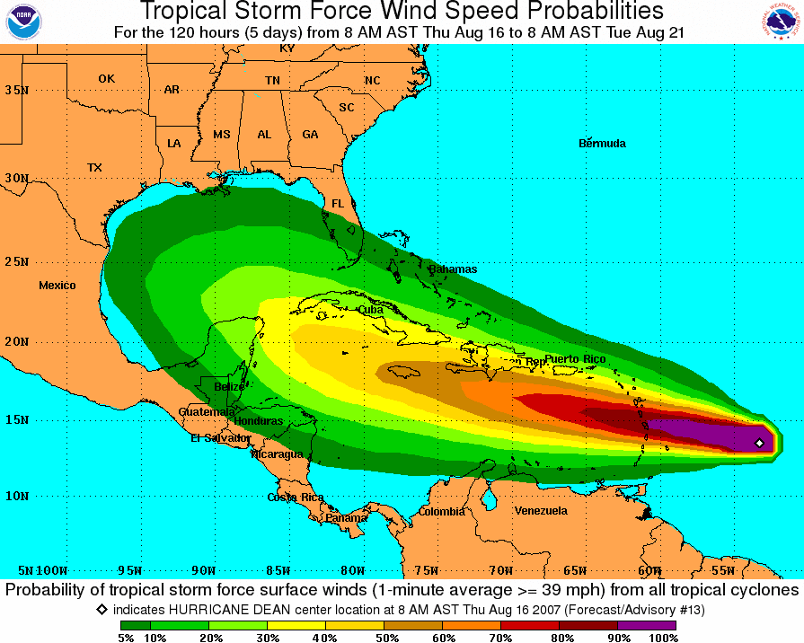
Tropical Cyclone Surface Wind Speed Probabilities (PWS)
World Meteorological Organization (WMO) and AWIPS (in parenthesis) headers:FONT11-15 KNHC (MIAPWSAT1-5) – Atlantic
FOPZ11-15 KNHC (MIAPWSEP1-5) – Eastern Pacific
FOPA11-15 PHFO (HNLPWSCP1-5) – Central Pacific (issued by CPHC)
The Tropical Cyclone Surface Wind Speed Probabilities text product provides probabilities, in percent, of sustained wind speeds equal to or exceeding 34-, 50-, and 64-knot wind speed thresholds. These wind speed probabilities are based on the track, intensity, and wind structure forecasts and uncertainties from the National Hurricane Center and the Central Pacific Hurricane Center and are computed for coastal and inland cities as well as offshore locations (e.g., buoys).
These text products are issued on all Atlantic and eastern Pacific tropical and subtropical cyclones every six hours at 0300, 0900, 1500, and 2100 UTC (learn about UTC time). Special tropical cyclone surface wind speed probabilities may be issued at any time due to significant changes in warnings or in the cyclone.
The numbers 1-5 in the header are assigned on a rotating basis by cyclone number, i.e., probabilities on the first, sixth, or eleventh cyclones of the Atlantic season would be sent under the WMO header FONT11 KNHC; probabilities on the second, seventh, or twelfth cyclones of the Atlantic season would be sent under the WMO header FONT12 KNHC, and so on.
Three types of tropical cyclone wind speed probability values will be created during 2006. Not all of these values will be distributed or placed on the Internet. For each probability value, the event in question is a sustained (one-minute average) surface (10 m) wind speed of at least a particular threshold value (34, 50, or 64 kt) at a specific location.
Cumulative – These values tell you the overall probability the event will occur sometime during the specified cumulative forecast period (0-6 hours, 0-12, 0-18, etc.) at each specific point. These values are provided in both the text and graphical formats. In the text product, the numbers are in parentheses. The graphical products depict only cumulative values. The text product is transmitted to users via normal NWS dissemination methods. The graphic is available on the internet from the National Hurricane Center and the Central Pacific Hurricane Center.
Individual – These values tell you the probability the event will start
sometime during the specified individual forecast period (0 - 6 hours, 6-12, 12-18,
etc.) at each specific point. These periods are individual, since nothing that
occurs before or after the specified period affects the probability. These values
are provided only in the text NHC product. They are the values outside of the
parentheses (cumulative values are in the parentheses). The term "individual" also
makes a clear distinction from the cumulative period values for users.
Incremental – These values tell you the probability the event will occur sometime during the specified forecast period (0 - 6 hours, 6-12, 12-18, etc.) at each specific point. These values are incremental since they can increase in value by accounting for the possibility the event might start in an earlier period and still be occurring in the specified period.
Note: View a more detailed description of the wind speed probabilities products.
List of Cities by Basin: Atlantic – Eastern Pacific –
Central Pacific – Western Pacific
Tropical Cyclone Update (TCU)
World Meteorological Organization (WMO) and AWIPS (in parenthesis) headers:WTNT61-65 KNHC (MIATCUAT1-5) – Atlantic
WTPZ61-65 KNHC (MIATCUEP1-5) – E. Pacific
The TCU is a brief alphanumeric text product containing either block paragraph text, a formatted storm summary section, or both. TCUs are issued to inform users of significant changes in a tropical cyclone in between regularly scheduled public advisories. Such uses include, but are not limited to the following:
- To provide timely information of an unusual nature, such as the time and location of landfall, or to announce an expected change in intensity that results in an upgrade or downgrade of status (e.g., from a tropical storm to a hurricane).
- To provide a continuous flow of information regarding the center location of a tropical cyclone when watches or warnings are in effect and the center can be easily tracked with land-based radar.
- To provide advance notice that significant changes to storm information will be conveyed shortly, either through a subsequent TCU or through a Special Advisory.
- To announce changes to international watches or warnings made by other countries, or to cancel U.S. watches or warnings.
- To issue a U.S. watch or warning, but only if the TCU precedes a special advisory that will contain the same watch/warning information, and indicates the special advisory will be issued shortly.
The storm summary section is identical in format to the storm summary section found in the TCP. The storm summary section is required whenever the TCU is issued to update storm intensity, location, or motion information. The storm summary section is not required for TCUs issued to provide advance notice that significant changes to storm information will be conveyed shortly, or for those issued to convey changes to watches or warnings.
Tropical Cyclone Position Estimate (TCE)
The Tropical Cyclone Position Estimate (TCE) has been discontinued effective with the 2013 hurricane season. The relevant information can be found in the Tropical Cyclone Update (TCU). See the Service Change Notice for more information.
Tropical Weather Outlook (TWO)
World Meteorological Organization (WMO) and AWIPS (in parenthesis) headers:ABNT20 KNHC (MIATWOAT) – Atlantic
ABPZ20 KNHC (MIATWOEP) – E. Pacific
The Tropical Weather Outlook discusses significant areas of disturbed weather and their potential for development during the next 5 days, including a categorical forecast of the probability of tropical cyclone formation during the first 48 hours, and during the entire 5-day forecast period. The 48 h and 5-day probabilities of formation for each disturbance are given to the nearest 10% and expressed in terms of one of the following categories: low probability of development (0-30%), medium probability (40-60%), and high probability of development (70-100%).
The Tropical Weather Outlook is issued every six hours from 1 June–30 November for the Atlantic Basin and from 15 May–30 November for the eastern North Pacific Basin at 0000, 0600, 1200, 1800 UTC. Local issuance times are shown in the table below.
| Basin | Local Issuance Times During Daylight Savings Time | Local Issuance Times During Standard Time |
| Atlantic (1 June–30 November |
2:00 am EDT 8:00 am EDT 2:00 pm EDT 8:00 pm EDT |
1:00 am EST 7:00 am EST 1:00 pm EST 7:00 pm EST |
| Eastern North Pacific (15 May–30 November) |
5:00 am PDT 11:00 am PDT 5:00 pm PDT 11:00 pm PDT |
4:00 am PST 10:00 am PST 4:00 pm PST 10:00 pm PST |
A Special Tropical Weather Outlook is issued when there have been important changes with areas of disturbed weather over tropical or subtropical waters that need to be conveyed before the next scheduled release of the Tropical Weather Outlook. The Special Tropical Weather Outlook can be used to report the findings of reconnaissance aircraft missions, and can also be used for disturbances outside of the normal hurricane season when Tropical Weather Outlooks are not routinely issued. The disturbance being updated in the Special Tropical Weather Outlook will be highlighted at the top of the product, and other systems discussed in previous Tropical Weather outlooks will also be included.
Please note the (Special) Tropical Weather Outlook has a companion Graphical Tropical Weather Outlook that will be updated at the same time.
The most current Tropical Weather Outlook is found on the NHC home page.
Tropical Cyclone Valid Time Event Code (TCV)
World Meteorological Organization (WMO) and AWIPS (in parenthesis) headers:WTNT81-85 KNHC (MIATCVAT1-5) – Atlantic
WTPZ81-85 KNHC (MIATCVEP1-5) – E. Pacific
The Tropical Cyclone Watch/Warning text product (TCV) is based upon the Valid Time Event Code (VTEC). It summarizes all new, continued, and canceled tropical cyclone watches and warnings issued by the National Hurricane Center (NHC) for the U.S. Atlantic and Gulf coasts, Puerto Rico, and U.S. Virgin Islands. Beginning in 2008, the TCV will also include areas of southern California from Los Angeles to the United States/Mexico border.
Once watches and/or warnings are in effect for the areas mentioned, updates will be issued by the NHC at a minimum of every six hours at the regular advisory issuance time of 5:00 AM EDT, 11:00 AM EDT, 5:00 PM EDT, and 11:00 PM EDT (or 4:00 AM EST, 10:00 AM EST, 4:00 PM EST, and 10:00 PM EST). TCVs for special advisories will be issued for the same circumstances that apply for a standard advisory.
When active, the most current Tropical Cyclone Valid Time Event Code (VTEC) product can be found on the NHC home page.
Additionally, a more detailed description about this product can be found at the TCV overview page. An overview of the VTEC program is available at http://www.nws.noaa.gov/om/vtec/.
Tropical Cyclone ICAO (Aviation) Advisory (TCA)
World Meteorological Organization (WMO) and AWIPS (in parenthesis) headers:FKNT21-25 KNHC (MIATCANT1-5) – Atlantic
FKPZ21-25 KNHC (MIATCAPZ1-5) – E. Pacific
The Aviation Tropical Cyclone Advisory is issued to provide short term tropical cyclone forecast guidance for international aviation safety and routing purposes. The TCA lists the current TC position, motion, and intensity, and includes 6, 12, 18, and 24 hour forecast positions and intensities. Position and intensity information for forecast hours (+06, +12, +18 and +24) is derived from interpolated forecast information – intensity is rounded to the nearest 5 knots.
Issuance of the Aviation Tropical Cyclone Advisory occurs every six hours at the regular advisory issuance time of 0300, 0900, 1500, and 2100 UTC (learn about UTC time). For 2008, the bulletin's information is valid at the routine advisory times (0300, 0900, 1500 and 2100 UTC) and is not anchored to the synoptic times. TCAs for special advisories will be issued for the same circumstances that apply for a standard advisory.
Hurricane Local Statement (HLS)
These statements are NOT produced at the National Hurricane Center, but can be found through links in the NHC storm table when an active tropical cyclone threatens U.S. land. Local National Weather Service Weather Forecast Offices (WFOs) produce these local statements to keep the media, local decision makers, and the public current on present and anticipated storm effects in their area. The hurricane local statements contain essential hurricane or tropical storm information in a condensed form, but expand on the storm's potential effects on the local area and on any actions declared by local emergency managers.
Local weather statements generally present the following:
- A lead statement
- A sentence detailing the counties, parishes, or cities covered by the statement
- Watches and/or warnings in effect and the counties or parishes to which they apply
- Recommended precautionary actions and the times they should be completed
- Storm surge and storm tide information, including the times that various heights are expected, present heights, and their locations
- Present winds and the expected time of onset of tropical storm or hurricane-force winds
- Tornado, flood, flash flood, rip current, beach erosion, and inland high wind potential
- The time of the next statement
- Information on the probability of hurricane or tropical storm conditions may also be included. An example section of a hurricane local statement is provided below.
The Graphical HLS provides local hurricane hazards in a graphical format.
See NWS Weather Forecast Office locations to find your local office.
Monthly Tropical Weather Summary (TWS)
World Meteorological Organization (WMO) and AWIPS (in parenthesis) headers:ABNT30 KNHC (MIATWSAT) – Atlantic
ABPZ30 KNHC (MIATWSEP) – E. Pacific
The Monthly Tropical Weather Summary is issued on the first day of every month during the hurricane season. It briefly describes the previous month's tropical cyclone actvity and gives a table of basic meteorological statistics, such as the dates of occurrence and estimated peak intensity, for all of the season's tropical cyclones to date.
Users requiring comprehensive information on each tropical cyclone including synoptic history, meteorological statistics, casualties and damages, and the post-analysis best track (six-hourly positions and intensities), are encouraged to consult the end of season tropical cyclone reports. Atlantic and East Pacific tropical cyclone reports are available at www.nhc.noaa.gov/data/tcr/.
Atlantic Tropical Weather Summaries are issued under WMO and AWIPS header ABNT30 KNHC and MIATWSAT. Eastern Pacific Tropical Weather Summaries are issued under WMO header ABPZ30 KNHC and AWIPS header MIATWSEP.
The most current Monthly Tropical Weather Summary is found on the NHC home page.
Tropical Cyclone Reports (TCR)
These reports are available on the NHC TCR webpage.The National Hurricane Center's Tropical Cyclone Reports (formerly called Preliminary Reports) contain comprehensive information on each storm, including synoptic history, meteorological statistics, casualties and damages, and the post-analysis best track (six-hourly positions and intensities). Tropical cyclones include depressions, storms and hurricanes. Tropical depressions listed in the table of contents are those that did not reach tropical storm strength.
Tropical Cyclone Reports (TCRs) are composed after a tropical cyclone has reached its end of life, and all pertinent data has been gathered and analyzed. Once completed, the TCRs are posted to the NHC TCR webpage.