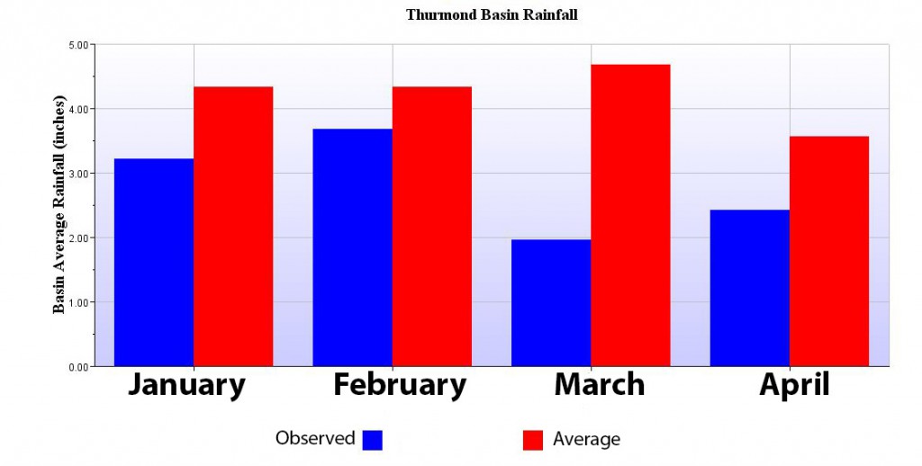
The last three months of 2015 brought with it a surge of precipitation that exceeded normal rainfall by more than 200 percent across the upper Savannah River Basin. At Thurmond in particular December rainfall approached 300 percent of normal, soaking the basin a final time before spring and saturating soil to its capacity.
However, since December the basin has experienced below average rainfall every month (a 7-inch deficit between Hartwell and Thurmond through April).  During this period the reservoir levels remained favorable due to the year-end precipitation. Although rainfall since January has only been 64 percent of normal, inflows have remained near normal due to the saturated soil and higher runoff rates.
Due to rainfall deficits this spring we are beginning to see indicators the soil is no longer saturated, and inflows are beginning to match the reduced level of rainfall we’ve observed over the last four months.
This is easier to comprehend with a visual. The below hydrograph measures inflow on a 28-day average from the Broad River, an unregulated tributary that flows into Thurmond. The colored layers represent a range in percentile of flow volume with the center green layer showing the normal range (25th to 75th percentile). Note that throughout the year the layers have peaks and valleys, reflecting the seasonal wet and dry periods.
The thick black line reveals observed flows for the past 17 months. Notice that near the end of January a sharp decline begins and endures to the present time, creating a cross-hatch with the seasonal wet period. According to the percentile layers (based on 28-day averages) that black line should be ascending from February to about mid-April. But despite ground saturation it shows descent. Present conditions reveal inflow is in the 19th percentile and dropping.
This is important because as the ground becomes dry, inflows (and therefore reservoir levels) will be less responsive to rainfall. The ground and vegetation get the first share of rainfall.
Further, the Drought Monitor is indicating most of the upper basin is currently in moderate drought, despite our reservoirs being nearly full. (NOAA uses a variety of condition indicators to determine drought. The Corps primarily uses reservoir levels as an aid in making operational decisions.)
What does all this mean for reservoirs levels in the near future?
We’re not in the business of forecasting weather, so we’ll leave it to the imagination of the reader to determine what conditions may be like by the end of summer if rainfall trends from the last four months continue throughout the summer.
We welcome your input.
~Russell Wicke
Chief, Corporate Communications


