Pittsburgh District Header Image

PITTSBURGH DISTRICT

Home
Home > Missions > Water Management

Water Management

Roadmap of District with projects
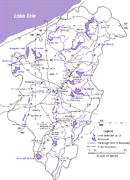
Known as the Headwaters District, the Pittsburgh District is comprised of the Ohio River drainage basin above New Martinsville, West Virginia. The District covers an area of approximately 67,000 square kilometers (26,000 square miles), including portions of Pennsylvania, West Virginia, Ohio, New York and Maryland. Major river systems within the Pittsburgh District include the upper Ohio, the Allegheny, the Monongahela and the Beaver. The District manages 16 flood control and multipurpose reservoirs with a combined capacity of over 3.8 billion cubic meters (3 million acre feet) and 23 navigation locks and dams on 530 kilometers (330 miles) of navigable waterways. In addition, the District operates Lake Milton for the state of Ohio. Pittsburgh District Water Management provides accurate and timely information on conditions at Corps of Engineers reservoirs, as well as levels along rivers and streams within the Pittsburgh District.

(Click here or on map for larger image)

Reservoir Conditions

Daily Reservoir Report and Forecast - Current and expected pool levels and releases for the next three days. Graphical reservoir pool and outflow readings and forecasts are available from the National Weather Service.

The U.S. Geological Survey provides statewide lake and reservoir tables for:

NOTE - Between January 2010 and January 2012, the Pittsburgh District converted all reservoir pool gages from the NGVD29 datum to the NAVD88 datum. The Corps has prepared a brochure explaining the datums. Questions about our Water Management program or conditions at Corps of Engineers reservoirs, as well as levels along rivers and streams within the Pittsburgh District, can be addressed to our Reservoir Control Center at (412)395-7300.

River Conditions

Data are obtained by satellite telemetry from field gaging stations and Hydro Lab units, and are NOT CHECKED OR VERIFIED before being posted.

Water Quantity and Quality Data for the Region

The U.S. Geological Survey provides statewide streamflow tables for:

The National Weather Service AHPS provides current and forecast river data for the Pittsburgh Area.

Weekend Recreation Outlook

Collapse All Expand All

Updated on 13 October 2016

This morning Conemaugh Lake was at 911.3 ft (NAVD88), rising, and releasing about 630 cfs. This morning the Vandergrift stage was at 3.80 ft. and should continue to slowly fall through the weekend.  The latest observed Vandergrift stage is available here.

The weather forecast for Vandergrift is provided by the National Weather Service.

Our primary reference for canoeing information is the Canoeing Guide to Western Pennsylvania and Northern West Virginia. It indicates levels that are recommended limits for safe canoeing on the Conemaugh and Kiski.

Long Term Outlook

As always, we are operating Conemaugh and Loyalhanna Lakes in accordance to their authorized project purpose of flood control. Operations (gate changes) can only be made for project purposes for which storage has been allocated. Any other project purposes (i.e., recreation) are accommodated to the extent feasible.

Updated on 13 October 2016

Today Youghiogheny Dam is at 1397.09 ft (NAVD88), falling, and releasing about 520 cfs. Today the Ohiopyle gage is at 1.8 ft and falling slowly.  During the day on 15 October, there is an Over-the-Falls Festival were we expect to keep Ohiopyle at 1.7’.  On the afternoon of 15 October, we expect to increase releases to 620 cfs, in order to keep Ohiopyle over 1.8 ft through the rest of the weekend.  The current NWS River Forecast for Ohiopyle can be found here.  The NWS river models always include the effects of expected future Corps operations.  Current and projected lake levels and releases are shown here.

The weather forecast for Ohiopyle is provided by the National Weather Service.

Lake recreation users can call (814) 395-3166 for the current recorded information message on daily pool and outflow levels, safety, recreation, special events and fishing.

You can also call Ohiopyle State Park at (724) 329-8591 to hear a recorded message giving the daily stage reading.

Long Term Outlook

As always, we are operating Youghiogheny River Lake in accordance with its authorized project purposes of flood control, water quality control, and water supply. Operations (gate changes) can only be made for project purposes for which storage has been allocated. Other project purposes (i.e., fish and wildlife enhancement and recreation) are accommodated to the extent feasible. We continue to attempt to operate the project considering the needs of recreation users both on the lake and the river.

The outlooks above are generally updated every Thursday during recreation season.

Navigation Reports

Allegheny and Monongahela Rivers - Morning Report
Allegheny and Monongahela Rivers - Latest Report