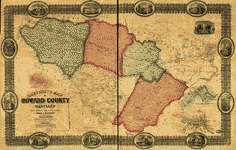
Map
Martenet's Map of Howard County, Maryland : drawn entirely from actual surveys /
| Format |
Map |
|---|---|
| Contributors |
Martenet, Simon J. |
| Dates |
1860 |
| Location |
Howard County Maryland United States |
| Language |
English |
| Subjects |
Howard County Maryland Real Property United States |
- Title
- Martenet's Map of Howard County, Maryland : drawn entirely from actual surveys /
- Description
-
Landowners identified.
-
LC Land ownership maps, 296
-
Includes illus. and 3 insets.
-
Available also through the Library of Congress Web site as a raster image.
-
1 map : hand col. ; 84 x 134 cm.
- Creator
- Martenet, Simon J.
- Created Published
-
Baltimore : John Schofield, c1860.
- Subject Headings
-
-
Real property--Maryland--Howard County
-
-
United States--Maryland--Howard County.
- Notes
-
-
Landowners identified.
-
-
LC Land ownership maps, 296
-
-
Includes illus. and 3 insets.
-
-
Available also through the Library of Congress Web site as a raster image.
- Medium
-
1 map : hand col. ; 84 x 134 cm.
- Call Number
-
G3843.H6 1860 .M3 TIL
- Repository
-
Library of Congress Geography and Map Division Washington, D.C. 20540-4650 USA dcu
- Digital Id
-
g3843h la000296 http://hdl.loc.gov/loc.gmd/g3843h.la000296
- Library of Congress Catalog Number
- 2002624032
Rights & Access
The maps in the Map Collections materials were either published prior to 1922, produced by the United States government, or both (see catalogue records that accompany each map for information regarding date of publication and source). The Library of Congress is providing access to these materials for educational and research purposes and is not aware of any U.S. copyright protection (see Title 17 of the United States Code) or any other restrictions in the Map Collection materials.
Note that the written permission of the copyright owners and/or other rights holders (such as publicity and/or privacy rights) is required for distribution, reproduction, or other use of protected items beyond that allowed by fair use or other statutory exemptions. Responsibility for making an independent legal assessment of an item and securing any necessary permissions ultimately rests with persons desiring to use the item.
More about Copyright and other Restrictions
For guidance about compiling full citations consult Citing Primary Sources.
Part of...
-
Cultural Landscapes
[1623]
-
Geography And Maps Division
[60803]
-
American Memory
[1121009]
More maps like this
-
 Martenet's Map of Carroll County, Maryland : entirely from actual surveys /
Contributor:
Martenet, Simon J.
Site:
American Memory-cultural, Main Catalog
Original Format:
Map
Date:
1862
View catalog record
Martenet's Map of Carroll County, Maryland : entirely from actual surveys /
Contributor:
Martenet, Simon J.
Site:
American Memory-cultural, Main Catalog
Original Format:
Map
Date:
1862
View catalog record
-
 Martenet's Map of Harford County, Maryland : shore lines and tide water from U.S. Coast Survey, the county from actual surveys /
Contributor:
Martenet, Simon J.
Site:
American Memory-cultural, Main Catalog
Original Format:
Map
Date:
1878
View catalog record
Martenet's Map of Harford County, Maryland : shore lines and tide water from U.S. Coast Survey, the county from actual surveys /
Contributor:
Martenet, Simon J.
Site:
American Memory-cultural, Main Catalog
Original Format:
Map
Date:
1878
View catalog record
-
 Martenet's map of Kent County, Maryland ; shore lines and soundings from U.S. Coast Survey, roads and inland from actual surveys by C.H. Baker, county ...
Contributor:
Martenet, Simon J.
Site:
American Memory-cultural, Main Catalog
Original Format:
Map
Date:
1860
View catalog record
Martenet's map of Kent County, Maryland ; shore lines and soundings from U.S. Coast Survey, roads and inland from actual surveys by C.H. Baker, county ...
Contributor:
Martenet, Simon J.
Site:
American Memory-cultural, Main Catalog
Original Format:
Map
Date:
1860
View catalog record
-
 Martenet's Map of Prince George's County, Maryland.
Contributor:
Martenet, Simon J.
Site:
American Memory-cultural, Main Catalog
Original Format:
Map
Date:
1861
View catalog record
Martenet's Map of Prince George's County, Maryland.
Contributor:
Martenet, Simon J.
Site:
American Memory-cultural, Main Catalog
Original Format:
Map
Date:
1861
View catalog record
-
 Martenet's Map of Cecil County, Maryland : from the coast, and original surveys /
Contributor:
Martenet, Simon J.
Site:
American Memory-cultural, Main Catalog
Original Format:
Map
Date:
1858
View catalog record
Martenet's Map of Cecil County, Maryland : from the coast, and original surveys /
Contributor:
Martenet, Simon J.
Site:
American Memory-cultural, Main Catalog
Original Format:
Map
Date:
1858
View catalog record
-
 Scott's map of the city of Baltimore. From latest records and actual surveys by
Contributor:
Martenet, Simon J.
Site:
American Memory-cultural, Main Catalog
Original Format:
Map
Date:
1856
View catalog record
Scott's map of the city of Baltimore. From latest records and actual surveys by
Contributor:
Martenet, Simon J.
Site:
American Memory-cultural, Main Catalog
Original Format:
Map
Date:
1856
View catalog record
-
 Martenet's map of Anne Arundel County, Maryland : shore lines, soundings, &c. &c. from U.S. surveys /
Contributor:
Martenet, Simon J.
Site:
American Memory-cultural, Main Catalog
Original Format:
Map
Date:
1860
View catalog record
Martenet's map of Anne Arundel County, Maryland : shore lines, soundings, &c. &c. from U.S. surveys /
Contributor:
Martenet, Simon J.
Site:
American Memory-cultural, Main Catalog
Original Format:
Map
Date:
1860
View catalog record
-
 Martenet and Bond's map of Montgomery County, Maryland /
Contributor:
Martenet, Simon J.
Site:
American Memory-cultural, Main Catalog
Original Format:
Map
Date:
1865
View catalog record
Martenet and Bond's map of Montgomery County, Maryland /
Contributor:
Martenet, Simon J.
Site:
American Memory-cultural, Main Catalog
Original Format:
Map
Date:
1865
View catalog record
-
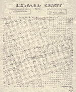 Howard County, Texas /
Contributor:
Stakemann, M.
Site:
American Memory-cultural, Main Catalog
Original Format:
Map
View catalog record
Howard County, Texas /
Contributor:
Stakemann, M.
Site:
American Memory-cultural, Main Catalog
Original Format:
Map
View catalog record
-
 Map of Caroline County, Maryland
Contributor:
Isler, John B.
Site:
American Memory-cultural, Main Catalog
Original Format:
Map
Date:
1875
View catalog record
Map of Caroline County, Maryland
Contributor:
Isler, John B.
Site:
American Memory-cultural, Main Catalog
Original Format:
Map
Date:
1875
View catalog record
-
 Map of Talbot County; with farm limits.
Contributor:
Dilworth, William H.
Site:
American Memory-cultural, Main Catalog
Original Format:
Map
Date:
1858
View catalog record
Map of Talbot County; with farm limits.
Contributor:
Dilworth, William H.
Site:
American Memory-cultural, Main Catalog
Original Format:
Map
Date:
1858
View catalog record
-
 Plan of Charles Town, Maryland.
Site:
American Memory-cultural, Main Catalog
Original Format:
Map
Date:
1770
View catalog record
Plan of Charles Town, Maryland.
Site:
American Memory-cultural, Main Catalog
Original Format:
Map
Date:
1770
View catalog record
-
 S. S. Downin's plat of Joseph Poffenberger /
Contributor:
Downin, S. S.
Site:
American Memory-cultural, Main Catalog
Original Format:
Map
Date:
1851
View catalog record
S. S. Downin's plat of Joseph Poffenberger /
Contributor:
Downin, S. S.
Site:
American Memory-cultural, Main Catalog
Original Format:
Map
Date:
1851
View catalog record
-
 Map of the city and county of Baltimore, Maryland.
Contributor:
Taylor, Robert
Site:
American Memory-cultural, Main Catalog
Original Format:
Map
Date:
1857
View catalog record
Map of the city and county of Baltimore, Maryland.
Contributor:
Taylor, Robert
Site:
American Memory-cultural, Main Catalog
Original Format:
Map
Date:
1857
View catalog record
-
 Section no. 2, Chevy Chase, Maryland /
Contributor:
Thos. J. Fisher and Co
Site:
American Memory-cultural, Main Catalog
Original Format:
Map
Date:
1909
View catalog record
Section no. 2, Chevy Chase, Maryland /
Contributor:
Thos. J. Fisher and Co
Site:
American Memory-cultural, Main Catalog
Original Format:
Map
Date:
1909
View catalog record
-
 [Survey of the property of George Poffenberger and Mrs. Nicodemus in Washington County, Md.] /
Contributor:
Downin, S. S.
Site:
American Memory-cultural, Main Catalog
Original Format:
Map
Date:
1883
View catalog record
[Survey of the property of George Poffenberger and Mrs. Nicodemus in Washington County, Md.] /
Contributor:
Downin, S. S.
Site:
American Memory-cultural, Main Catalog
Original Format:
Map
Date:
1883
View catalog record
You might also like
-
 Doughoregan Manor. View of Doughoregan Manor
Contributor:
Horydczak, Theodor
Site:
Prints & Photographs
Original Format:
Photo, Print, Drawing
Date:
1920
Doughoregan Manor. View of Doughoregan Manor
Contributor:
Horydczak, Theodor
Site:
Prints & Photographs
Original Format:
Photo, Print, Drawing
Date:
1920
-
 Doughoregan Manor. Interior of chapel at Doughoregan Manor I
Contributor:
Horydczak, Theodor
Site:
Prints & Photographs
Original Format:
Photo, Print, Drawing
Date:
1920
Doughoregan Manor. Interior of chapel at Doughoregan Manor I
Contributor:
Horydczak, Theodor
Site:
Prints & Photographs
Original Format:
Photo, Print, Drawing
Date:
1920
-
 Doughoregan Manor. Interior of chapel at Doughoregan Manor II
Contributor:
Horydczak, Theodor
Site:
Prints & Photographs
Original Format:
Photo, Print, Drawing
Date:
1920
Doughoregan Manor. Interior of chapel at Doughoregan Manor II
Contributor:
Horydczak, Theodor
Site:
Prints & Photographs
Original Format:
Photo, Print, Drawing
Date:
1920
-
 Doughoregan Manor. Exterior of chapel at Doughoregan Manor
Contributor:
Horydczak, Theodor
Site:
Prints & Photographs
Original Format:
Photo, Print, Drawing
Date:
1920
Doughoregan Manor. Exterior of chapel at Doughoregan Manor
Contributor:
Horydczak, Theodor
Site:
Prints & Photographs
Original Format:
Photo, Print, Drawing
Date:
1920
-
 Doughoregan Manor. View of Doughoregan Manor and part of the gardens
Contributor:
Horydczak, Theodor
Site:
Prints & Photographs
Original Format:
Photo, Print, Drawing
Date:
1920
Doughoregan Manor. View of Doughoregan Manor and part of the gardens
Contributor:
Horydczak, Theodor
Site:
Prints & Photographs
Original Format:
Photo, Print, Drawing
Date:
1920
-
 Doughoregan Manor. Two children in gardens at Doughoregan Manor
Contributor:
Horydczak, Theodor
Site:
Prints & Photographs
Original Format:
Photo, Print, Drawing
Date:
1920
Doughoregan Manor. Two children in gardens at Doughoregan Manor
Contributor:
Horydczak, Theodor
Site:
Prints & Photographs
Original Format:
Photo, Print, Drawing
Date:
1920