USGS - science for a changing world
Logo and link to The National Map

The National Map: Historical Topographic Map Collection

Skip Links

The National Map Home >> Historical Topographic Map Collection


This is a formatting graphic.
Historical Topo Highlight
  • YUMA, MI 2014 (ORTHOIMAGE OFF)
    7.5 MINUTE SERIES QUADRANGLE (1:24,000–SCALE)
    US TOPO MAP
    click on map to view larger image
    download map (GeoPDF 27.3 MB)
    Thumbnail image of the 2014 Yuma, Michigan 7.5 minute series quadrangle (1:24,000-scale), US Topo map (orthoimage layer off)
  • YUMA, MI 2014 (ORTHOIMAGE ON)
    7.5 MINUTE SERIES QUADRANGLE (1:24,000–SCALE)
    US TOPO MAP
    click on map to view larger image
    download map (GeoPDF 27.3 MB)
    Thumbnail image of the 2014 Yuma, Michigan 7.5 minute series quadrangle (1:24,000-scale), US Topo map (orthoimage layer on)
  • YUMA, MI 2014 (SHADED RELIEF ON)
    7.5 MINUTE SERIES QUADRANGLE (1:24,000–SCALE)
    US TOPO MAP
    click on map to view larger image
    download map (GeoPDF 27.3 MB)
    Thumbnail image of the 2014 Yuma, Michigan 7.5 minute series quadrangle (1:24,000-scale), US Topo map (shaded relief and woodland layers on; contour and orthoimage layers off)
  • YUMA, MI 2012 (ORTHOIMAGE OFF)
    7.5 MINUTE SERIES QUADRANGLE (1:24,000–SCALE)
    HISTORICAL US TOPO MAP
    click on map to view larger image
    download map (GeoPDF 24.4 MB)
    Thumbnail image of the 2012 Yuma, Michigan 7.5 minute series quadrangle (1:24,000-scale), historical US Topo map (orthoimage layer off)
  • YUMA, MI 2012 (ORTHOIMAGE ON)
    7.5 MINUTE SERIES QUADRANGLE (1:24,000–SCALE)
    HISTORICAL US TOPO MAP
    click on map to view larger image
    download map (GeoPDF 24.4 MB)
    Thumbnail image of the 2012 Yuma, Michigan 7.5 minute series quadrangle (1:24,000-scale), historical US Topo map (orthoimage layer on)
  • TRAVERSE CITY, MI 1989
    1 X 2 DEGREE SERIES QUADRANGLE (1:250,000–SCALE)
    HISTORICAL TOPOGRAPHIC MAP
    click on map to view larger image
    download map (GeoPDF 24.1 MB)
    Thumbnail image of the 1989 Traverse City, Michigan 1 X 2 degree series quadrangle (1:250,000-scale), historical topographic map
  • YUMA, MI 1987
    7.5 MINUTE SERIES QUADRANGLE (1:24,000–SCALE)
    HISTORICAL TOPOGRAPHIC MAP
    click on map to view larger image
    download map (GeoPDF 11.7 MB)
    Thumbnail image of the 1987 Yuma, Michigan 7.5 minute series quadrangle (1:24,000-scale), historical topographic map
  • CADILLAC, MI 1983
    30x60 MINUTE SERIES QUADRANGLE (1:100,000–SCALE)
    HISTORICAL TOPOGRAPHIC MAP
    click on map to view larger image
    download map (GeoPDF 24.6 MB)
    Thumbnail image of the 1983 Cadillac, Michigan 30 x 60 minute series quadrangle (1:100,000-scale), historical topographic map.
  • COPEMISH, MI 1957
    15 MINUTE SERIES QUADRANGLE (1:62,500–SCALE)
    HISTORICAL TOPOGRAPHIC MAP
    click on map to view larger image
    download map (GeoPDF 8.3 MB)
    Thumbnail image of the 1957 Copemish, Michigan 15 minute series quadrangle (1:62,500-scale), historical topographic map.
  • TRAVERSE CITY, MI 1954
    1 x 2 DEGREE SERIES QUADRANGLE (1:250,000–SCALE)
    HISTORICAL TOPOGRAPHIC MAP
    click on map to view larger image
    download map (GeoPDF 22.6 MB)
    Thumbnail image of the 1954 Traverse City, Michigan 1 x 2 degreee series quadrangle (1:250,000-scale), historical topographic map.

Historical Topographic Maps - Preserving the Past

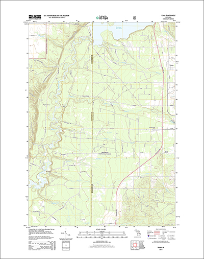
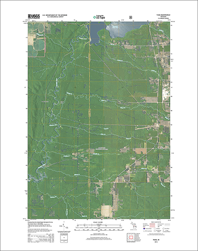
In 2009, USGS began the release of a new generation of topographic maps (US Topo) in electronic form, and is now complementing them with the release of high-resolution scans of more than 178,000 historical topographic maps of the United States. The topographic map remains an indispensable tool for everyday use in government, science, industry, land management planning, and recreation.

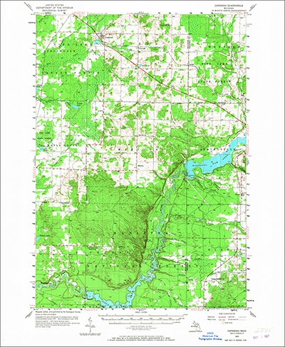
Historic maps are snapshots of the nation's physical and cultural features at a particular time. Maps of the same area can show how an area looked before development and provide a detailed view of changes over time. Historical maps are often useful to scientists, historians, environmentalists, genealogists and others researching a particular geographic location or area.

The goal of The National Map's Historical Topographic Map Collection (HTMC) is to scan all the USGS historic topographic maps published by the USGS since the inception of the topographic mapping program in 1884. The National Geospatial Program (NGP) is accurately cataloging and creating metadata to accompany high-resolution, geo-referenced digital files representing the legacy lithographic maps. These maps are either no longer available for distribution in print or are being replaced by the new generation of US Topo maps

The Historical Topographic Map Collection (HTMC) exists online as a digital collection at http://nationalmap.gov/historical/ and as a physical paper collection of maps in the USGS Clarence King Library in Reston, Virginia.

GeoPDF versions of HTMC maps can be downloaded free of charge from these applications:

The newest generation of USGS topographic maps, US Topo, are also available online for download through these same three applications.

For tutorial information on download and product use, see the US Topo Users Guide.


For more information contact us.


 Free document viewers: Adobe Reader | Microsoft Word | Microsoft Excel | Microsoft Powerpoint
 

Accessibility FOIA Privacy Policies and Notices

Take Pride in America logo USA.gov logo U.S. Department of the Interior | U.S. Geological Survey
URL: http://nationalmap.gov/historical/index.html
Page Contact Information: Historical Topographic Map Collection
Page Last Modified: Tuesday, 26-Aug-2014 11:49:03 EDT