Climate Change
Great Plains Impacts & Adaptation
Great Plains

On This Page
Key Points
- Projected increases in temperature and more frequent droughts will further stress the region's primary water supply, the Ogallala aquifer.
- Changes in water availability are likely to present challenges to agriculture and key wetland habitats, such as prairie potholes.
- As young people move to urban areas, older residents in rural areas and people living on Native American reservations may be particularly susceptible to impacts of climate change.
Related Links
EPA:
- Climate Change and Water: Great Plains
- EPA, A Student's Guide to Global Climate Change: Effects on People and the Environment
- EPA Region 6 (including the Great Plains states of NM, OK, and TX)
- EPA Region 7 (including the Great Plains states of KS, ND, NE, and SD)
- EPA Region 8 (including the Great Plains states of CO, MT, and WY)
Other:
- USGCRP Climate Change Wildlife and Wildlands: Prairie Grassland
- USGCRP Global Climate Change Impacts in the United States: Great Plains
- USDA, Office of the Chief Economist. Global Climate Change: Resources
- USGCRP Synthesis Assessment Product 4.3: The effects of climate change on agriculture, land resources, water resources, and biodiversity in the United States
- USGCRP Synthesis Assessment Product 4.4: Preliminary review of adaptation options for climate-sensitive ecosystems and resources
-
NRC America's Climate Choices: Advancing the Science of Climate Change

-
ITEP, Tribes & Climate Change
 View enlarged image
Projected percentage spring precipitation change in Great Plains region by the 2080s to 2090s.
Source: USGCRP (2009)
Stretching from Canada to Mexico across the midsection of the country, the Great Plains region has a climate that varies greatly from north to south and east to west. While some southern portions of the region typically experience 70 to 100 days each year over 90°F, the northern portions typically see only 10 to 20 days above 90°F. [1] Meanwhile, the western Great Plains is semi-arid, while the eastern portion is considerably wetter.
Although all of the region can experience sweltering summers and cold winters, northern portions are known for their bitterly cold and snowy winters. Nevertheless, during the last 30 years, northern portions of the region have seen average winter temperatures rise to 7°F above historical averages. [1] Average year-round temperatures are also increasing. During this century, temperatures are projected to continue increasing, especially in the southern and central Great Plains during the summers. [1] Projections for future precipitation patterns vary within the region. Northern areas may become wetter while southern areas may become drier, especially during the summer. [1]
 View enlarged image
Prairie grasslands are typical ecosystems in the Great Plains.
Source: USGCRP (2012)
In 2007, the population in the Great Plains was 9.9 million, approximately 3% of the entire United States population. Although the population in most Great Plains counties has declined in the last 50 years, the population of the entire Great Plains region has increased by 102% since 1950. [2] Currently, more than two-thirds of the region's population lives in urban areas. Additionally, about 25% of the country's most rapidly growing cities are located in the Great Plains. [1] Ninety-six percent of this growth has occurred in Texas and Colorado. [2]
This urban migration and rapid growth increase the region's vulnerability to the impacts of climate change. For example, as populations decline in rural areas, health services may become concentrated primarily in cities. Moreover, in some cases, the growing cities are already struggling to manage their water resources, because demand is greater than supply. [1] Climate change may exacerbate these challenges.
Impacts on Water Resources
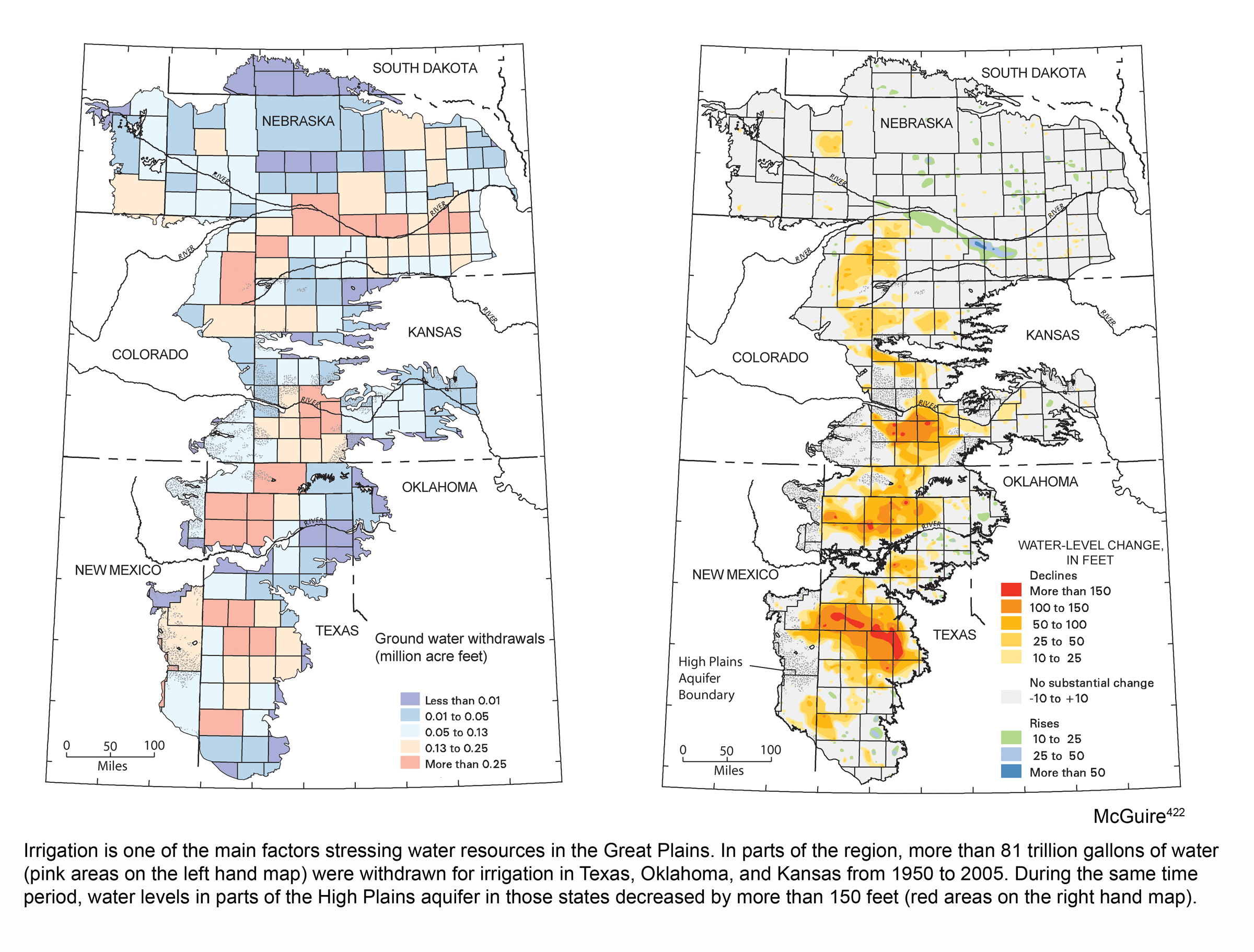
, the majority of the change in water level show a decline of between 25 to 150 feet. A few hotspots towards the south, especially in Texas, show declines that exceed 150 feet.")
Most of the region's water is supplied by the Ogallala aquifer (also known as the High Plains aquifer), which provides drinking water for more than 80% of the population and irrigates 13 million acres of land. [1] This underground reservoir is fed by precipitation and ancient stores of water that have been trapped in layers of sediment dating back to the last ice age.
Population, agricultural, and economic growth have increased the demand for water in the region. Water use now exceeds the recharge rate. As a result, since 1950, the average level of the aquifer has dropped by about 13 feet, approximately a 9% decrease in stored water. [1] In areas with heavy irrigation, the level has dropped by as much as 100 to 250 feet (see map of Ogallala aquifer). [1] Without alternative resources and better water management practices, projected temperature increases, more frequent droughts, and higher rates of evaporation are likely to further stress the water supply. [3]
Flooding is more likely to occur in the wetter, northern portions of the region. [1] Increases in heavy precipitation events may introduce contaminants to the water supply. This is because runoff from agriculture, industry, and roadways can be washed into water sources by heavy rains. [4]
For more information on climate change impacts on water, please visit the Water Resources Impacts page.
Impacts on Agriculture
More than 70% of the Great Plains' land area is used for agriculture. [1] The region's economy is historically heavily dependent on crops, including corn, wheat, barley, hay, and cotton. If extreme heat events and droughts become more frequent and temperatures continue to increase, the suitability of the Great Plains region for growing particular crops may change. Additionally, livestock are likely to face increased risk from heat stress and disease.
The threats to regional agriculture include the following:
- Northward spread of pests that previously could not survive the cooler northern climate (due to warmer winters and earlier springs)
- Potential increases in weed species due to more carbon dioxide in the atmosphere, high temperatures, and changes in precipitation
- Decreases in soil moisture and water availability

The Dust Bowl of 1935 in Stratford, TX.
Source: USGCRP (2009) (PDF)
In addition, periodic droughts have affected the Great Plains. Combined with poor agricultural land management, drought can have catastrophic effects. One prominent example was the Dust Bowl of the 1930s. Farmers in the 1920s routinely removed native grasses, which had been stabilizing the soil and reducing erosion. With the grasses gone, a long-term drought caused an estimated 100 million acres of topsoil to blow away across the country. [1] Although land management practices have improved since the Dust Bowl, stressors associated with climate change will need to be considered in order to prepare for the future. The combination of the projected warming temperatures and continued pressures on water and land resources could have negative impacts on regional agriculture. [1]
For more information on climate change impacts on agriculture, please visit the Agriculture and Food Supply page.
Impacts on Vulnerable Populations
Older people living in rural areas and Native Americans living on reservations may be especially vulnerable to some of the impacts of climate change. Their opportunities to relocate or change their livelihoods may be limited and they may have difficulty coping with impacts on water resources, agriculture, and ecosystems. [1]
There are 65 Native American tribes located in the Great Plains. Native Americans are sensitive to decreased crop reliability, reduced quality of rangelands, and the potential for water shortages. Given the boundaries of the reservations, some tribes may be limited in their ability to adapt. [1]
A significant number of young adults from rural areas are moving to urban areas. As young adults leave, small towns in the Great Plains are increasingly populated by older residents. The very young and the very old are particularly susceptible to the effects of extreme weather events. Approximately 80% of Great Plains counties have a higher percentage of older residents than the U.S. average. [2] In many of these areas, limited access to public health services may make the impacts particularly severe for vulnerable populations.
For more information on climate change impacts on vulnerable populations, please visit the Society page.

Prairie pothole Region Map
Source: FWS (2011)

Playa lakes after heavy rain, West Texas
Source: USGCRP (2009) (PDF)
Impacts on Ecosystems
Ten percent of the land area in the Great Plains is protected for wildlife habitat. [1] This protected area provides a home for many sensitive species of plants and animals. It also provides recreational opportunities for hunters and anglers. A number of birds (including ducks, geese, and quail), mammals (including moose and deer) and fish (including bass) are critical game species in these areas. [1] Many of these animals rely on the availability of prairie potholes and playa lakes, shallow lakes that periodically dry out. These seasonal lakes provide sites for many species to mate and nurture their offspring. Additionally, the lakes recharge the Ogallala aquifer.
Over the next several decades, the projected rise in temperatures, increases in evaporation rates, and more frequent periods of summer drought may cause the prairie potholes to dry out more frequently. Development and agricultural practices are already causing the loss of the prairie potholes. [1] This loss threatens the region's water supply and species, especially waterfowl, which rely on the prairie potholes to breed. [1] In conjunction with other regional pressures, such as population growth and agricultural management, climate change may place these unique and important habitats at increasing risk.
For more information on climate change impacts on ecosystems, please visit the Ecosystems Impacts page.
To learn more about what the Great Plains is doing to adapt to climate change impacts, please visit the adaptation section of the Great Plains Impacts and Adaptation page.
References
[1] USGCRP (2009). Global Climate Change Impacts in the United States . Karl, T.R., J. M. Melillo, and T. C. Peterson (eds.). United States Global Change Research Program. Cambridge University Press, New York, NY, USA.
[3] CCSP (2008). Preliminary Review of Adaptation Options for Climate-Sensitive Ecosystems and Resources . A Report by the U.S. Climate Change Science Program and the Subcommittee on Global Change Research. Julius, S.H., J.M. West (eds.), J.S. Baron, B. Griffith, L.A. Joyce, P. Kareiva, B.D. Keller, M.A. Palmer, C.H. Peterson, and J.M. Scott (authors). U.S. Environmental Protection Agency, Washington, DC, USA.
[4] CCSP (2008). The Effects of Climate Change on Agriculture, Land Resources, Water Resources, and Biodiversity in the United States . A Report by the U.S. Climate Change Science Program and the Subcommittee on Global Change Research. Backlund, P., A. Janetos, D. Schimel, J. Hatfield, K. Boote, P. Fay, L. Hahn, C. Izaurralde, B.A. Kimball, T. Mader, J. Morgan, D. Ort, W. Polley, A. Thomson, D. Wolfe, M. Ryan, S. Archer, R. Birdsey, C. Dahm, L. Heath, J. Hicke, D. Hollinger, T. Huxman, G. Okin, R. Oren, J. Randerson, W. Schlesinger, D. Lettenmaier, D. Major, L. Poff, S. Running, L. Hansen, D. Inouye, B.P. Kelly, L Meyerson, B. Peterson, and R. Shaw. U.S. Environmental Protection Agency, Washington, DC, USA.
