

Tweets
- Tweets
- Tweets & replies
- Media
@USGS_WA is blocked
Are you sure you want to view these Tweets? Viewing Tweets won't unblock @USGS_WA.
-
USGS was part of a team that collected samples from ice cave lakes in the crater atop Mt Rainier, Pierce Co, WA credit:
@DeRuydtsPhotopic.twitter.com/7cbEj1zFlP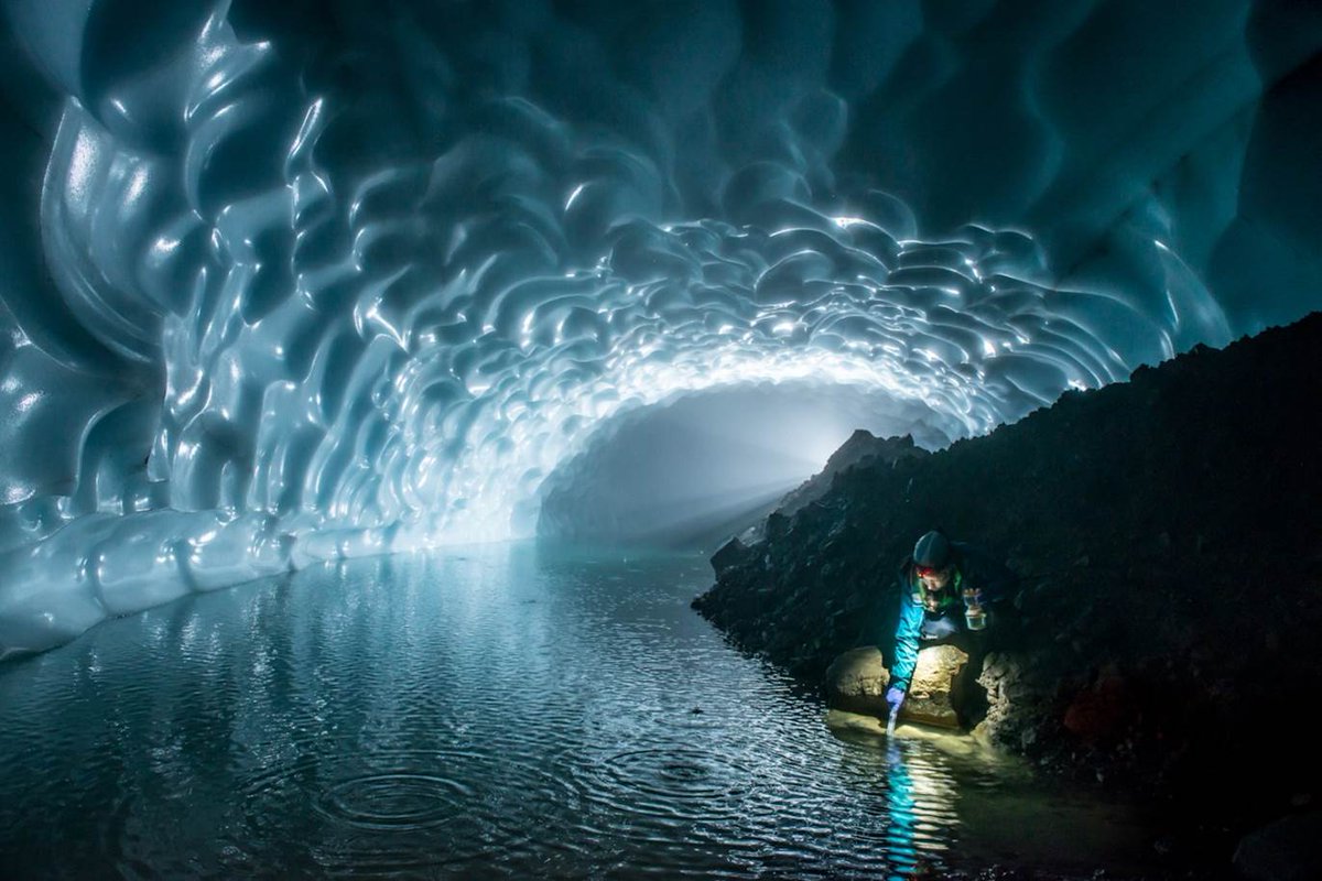
-
As most of you may know, our usual USGS Benchmark is round, much smaller, and in the middle of nowhere.https://twitter.com/rollakb/status/818545348595617792 …


-
New interactive water use maps by use and decade 1950-2010: https://owi.usgs.gov/vizlab/water-use/ …pic.twitter.com/d9O9413h3f

-
With October rain as much as 400% of normal so far, the rivers are much higher than normal for today as well... http://waterwatch.usgs.gov/?m=real&r=wa&w=real%2Cmap …pic.twitter.com/bAm71E5EOB

-
The Deschutes River is absolutely rippin right now with all of the Fall rains. Gettin misted at Lower Tumwater Falls.
#PNW#riverspic.twitter.com/cUVTXVvyq9 -
Take Winter By Storm's website has preparedness checklists in 11 languages. Spread the word.https://twitter.com/WinterByStorm/status/786425112065040384 …
-
This photo was taken at the Columbia River gage in Stevenson, Washington on Jan. 15 by one of our Pathways intern students, Ann McGowan.pic.twitter.com/1KMcad2c7c

-
In Washington, water continues to shape the land created by volcanoes, earthquakes, and ice ages. Fluvial geomorphology in action.https://twitter.com/kenlacovara/status/780870611027447808 …
 0:25
0:25 -
NEW: Mag:2.6 30.4 km SSE from Othello, WA Depth:2km 2016/09/01 19:22:UTC V0 https://is.gd/qB4sM8 pic.twitter.com/R2OrsImVSH

-
A second bat w/the fungus that causes White-Nose Syndrome was found in Washington according to
@USGS_WA and@USFWSpic.twitter.com/agJg2Am8Rw

-
We may not be ready for some rain, but our rivers are: 7-day average flows vs the historical average for August 30.pic.twitter.com/3jfVTPo3CR

-
-
This nice weather results in low streamflows.pic.twitter.com/YHVeJVWiTJ

-
There are numerous blue-green algae blooms currently in the Pacific Northwest as well.https://twitter.com/kswateroffice/status/768463658599022592 …

-
Flow tracker Qm, Bacon Creek near Marblemount, WApic.twitter.com/uGDbejsdus

-
Above-normal temps rest of week! Heightened fire Danger Thursday AM through Friday evening for wind & low humidity.pic.twitter.com/IxlpkMi2dd

-
Lookout Northeast WA Colville, Deer Park, north Spokane and neighboring cities. Thunder, heavy rain coming.pic.twitter.com/vW2yKGBzLv

-
68% of WA river flows are normal-and-above. 45-day avg. still below normal.
#wawx http://bit.ly/WAriverstoday pic.twitter.com/04pvsFt9Xc


-
MT: Hot Water Report for Columbia & Snake Rivers: http://www.wildsalmon.org/projects/climate-change/columbia-and-snake-rivers-hot-water-report-2017.html …
-
Heading to the river? Know the flow before you go: http://bit.ly/WAriverstoday pic.twitter.com/hUE5Ka3Yqq

 USGS in Washington
 Jacob McCann
 PNSN
PNSN
 Forest Service NW
 National Forest Fdn.
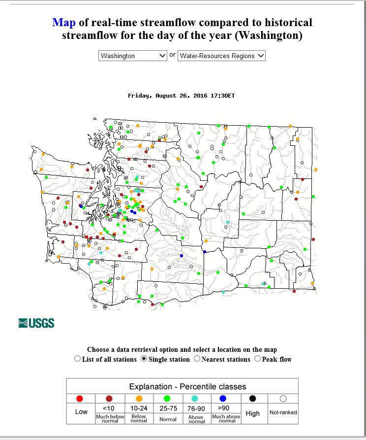
 Keisha Burns
 NWS Spokane
Loading seems to be taking a while.
Twitter may be over capacity or experiencing a momentary hiccup. Try again or visit Twitter Status for more information.