Land Survey Program

Corner Master Index - Online Searching and Ordering Available
Users can now search for and order certified land corner documents held in the department’s Corner Master Index. Certified land corner documents are also known as corner documents, tie sheets and corner records. This new system allows users to search the index by county name, township and range, document number and other search criteria. Online ordering is available and payment may be made online.
Cadastral Mapping Standards
Digital cadastral mapping data standards are presently being developed. A new draft reflecting the changes decided upon during the April 12, 2012 Stakeholder's Meeting has been updated. Interested individuals are encouraged to participate. Learn more.
Center of Population 2010
Plato gets survey marker and Missouri red granite monument designating it as center of U.S. population -- DNR Director Sara Parker Pauley reads and presents Gov. Jay Nixon’s proclamation. Learn more.
Supporting Science by Sharing Science

The mission of the Land Survey Program is to develop and provide information required for the accurate and economical location of property boundaries in Missouri. The program is comprised of four sections and are responsible for the following duties.
The Field Surveys Section is responsible for Cadastral and Geodetic Surveys in Missouri. Cadastral Surveys restore existing and obliterated corners of the United States Public Land Survey System. Hundreds of corners are restored, thousands perpetuated and documented through in-house projects, contracting and participation in the filing of Certified Land Corner Documents.
Missouri Height Modernization Survey

Let the surveying begin ...learn more
Geodetic Surveys define and manage a consistent coordinate system based on latitude, longitude and heights throughout Missouri. The Field Surveys Section is responsible for preservation and augmentation of the horizontal and vertical-control network within the State of Missouri. Baselines throughout the state validate and verify electronic distance measuring equipment.
The Document Preservation and Distribution Section is responsible for maintaining current documents in the Land Records Repository through contact with all county recorders and county surveyors throughout the State of Missouri. Requests for documents from land surveyors, other professionals and the public can be distributed in a number of formats from paper to digital.
History
What is the Public Land Survey System?
The United States Public Land Survey System (USPLSS) in Missouri is an extension of the system adopted by the United States Congress in 1785. Between 1816 and 1855, Missouri was surveyed into one mile squares called sections. Thirty-six sections in a block of land measuring six miles on each side is called a township. This created the basis for the transfer of the land from the United States Government to private owners and is the basis for all land transfers and ownership in the state today.
Why are these corners important?
The land corners are the basis for the location of all property in Missouri. Properly monumented, they are a dependable, consistent, accurate source of information for settling property boundary disputes and other boundary related questions. ...more
Sites of Interest
- Land Survey Index -- Search for land records
- Horizontal and Vertical Control Maps
- Geographic Reference System Monument Recovery Form
- Land Survey Advisory Committee
- Missouri Minimum Standards Presentation
- Land survey corners are the basis for the location of all property in Missouri
- You can order land records from our repository containing approximately 2 million documents
Articles
American Surveyor Magazine article, A Day at the Fair -- Educating the public at the Missouri State Fair about the work of professional land surveyors.
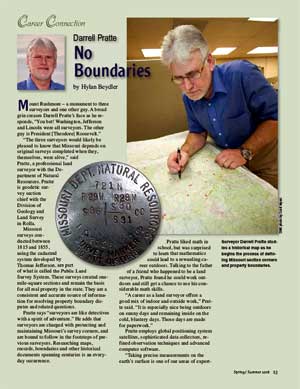
 Darrell Pratte Meet the State Land Surveyor and Land Survey Program Director
![]() Attention GPS Users -- Read the article, "Getting More from
Your Handheld GPS Unit," by
department land surveyor,
Steven Weible. The article appeared in The American Surveyor magazine.
Attention GPS Users -- Read the article, "Getting More from
Your Handheld GPS Unit," by
department land surveyor,
Steven Weible. The article appeared in The American Surveyor magazine.
Missouri Resources Magazine -- Read about a rewarding career with the department as a Professional Land Surveyor.
