- Current Hazards
- Forecasts
- Current Weather
- Radar Imagery
- Climate
- Weather Safety
- Additional Info
- Contact Us
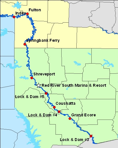
You're all prepared for a fishing or water skiing trip on your favorite area lake that you’ve had marked on the calendar for weeks in advance. You’ve probably even checked the weather forecast and it calls for a sunny day with south winds near 10 mph. Are these really the kind of winds you can expect on the open area of a lake or reservoir? Being an avid fisherman, I cannot tell you how many times I have checked the wind forecast before venturing out on my favorite lake and found the winds to be stronger than what was forecast. Any lake recreationalist will probably tell you the same thing. Too often, this results in treacherous boating conditions on our local waterways which can turn that enjoyable planned outing into a dangerously unpredictable one. During 2007, hourly wind observations were taken on various waterways across our region and were then compared to the closest airport wind observation for the same time. The results obtained from this study determined that there is an approximately 4 to 5 mph increase in sustained wind speeds on open bodies of water compared to the nearest airport. Keep in mind that this difference is over an open waterway and is not necessarily what one would find if they were boating in a protected pocket of the waterway or near wind protected structure such as a tree line, an island or point. The National Weather Service in Shreveport now issues a Recreational Forecast for different area waterways across Southeast Oklahoma, Southwest Arkansas, Northeast Texas as well as Northwest Louisiana. Below is a clickable map of the different waterways across the four-state region. Simply click on waterway of interest to see the Recreation Forecast and a hydrograph of the waterway if one is available. As this is a new forecast product, we greatly value your input into ways to make this website more usuful. Please contact Mike Berry with any suggestions, comments or questions. |
|
Place your cursor over the lake or river to see its name. |
|
|
|
|
 |
|
|
|
|
 |
- National Weather Service
- Shreveport, LA Weather Forecast Office
- 5655 Hollywood Ave.
- Shreveport, LA 71109
- 318-631-3669
- Page Author: SHV Webmaster
- Web Master's E-mail: sr-shv.webmaster@noaa.gov
- Page last modified: January 10th 2011 7:10 PM