Follow this link to skip to the main content NASA Jet Propulsion Laboratory California Institute of Technology JPL HOME EARTH SOLAR SYSTEM STARS & GALAXIES SCIENCE & TECHNOLOGY BRING THE UNIVERSE TO YOU JPL Email News RSS Mobile Video
JPL Banner
Mars Reconnaissance Orbiter
Home Participate
MULTIMEDIA
1   |  2   |  3   |  4   |  5   |  6   |  7   |  8   |  9   |  10   |  11   |  12   |  13   |  Next >     Last Page >>
This illustration schematically shows where the Shallow Radar instrument on NASA's Mars Reconnaissance Orbiter detected flood channels that had been buried by lava flows in the Elysium Planitia region of Mars.
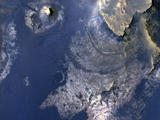
Visualization of Buried Marte Vallis Channels
The High Resolution Imaging Science Experiment (HiRISE) camera on NASA's Mars Reconnaissance Orbiter snapped this series of false-color pictures of sand dunes in the north polar region of Mars
Seasonal Changes on Far-Northern Mars
This view of layered rocks on the floor of McLaughlin Crater shows sedimentary rocks that contain spectroscopic evidence for minerals formed through interaction with water.
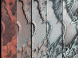
Layers with Carbonate Content Inside McLaughlin Crater on Mars (Annotated Figure 1)
This view of layered rocks on the floor of McLaughlin Crater shows sedimentary rocks that contain spectroscopic evidence for minerals formed through interaction with water.
Layers with Carbonate Content Inside McLaughlin Crater on Mars
This image maps the traverse of NASA's Mars rover Curiosity from "Bradbury Landing" to "Yellowknife Bay," with an inset documenting a change in the ground's thermal properties with arrival at a different type of terrain.
Curiosity's Traverse into Different Terrain
This map traces where NASA's Mars rover Curiosity drove between landing at a site subsequently named "Bradbury Landing," and the position reached during the mission's 123rd Martian day, or sol, (Dec. 10, 2012).
Curiosity Traverse Map, Sol 123
This image from the NASA Mars Reconnaissance Orbiter shows an impact scar on Mars made by pieces of the NASA Mars Science Laboratory spacecraft that the spacecraft shed just before entering the Martian atmosphere.
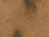
Impact Scars from MSL Cruise Stage and Two Balance Weights (Figure 2)
These images from the NASA Mars Reconnaissance Orbiter show several impact scars on Mars made by pieces of the NASA Mars Science Laboratory spacecraft that the spacecraft shed just before entering the Martian atmosphere.
Impact Scars from MSL Cruise Stage and Two Balance Weights (Figure 3)
These images from the NASA Mars Reconnaissance Orbiter show several impact scars on Mars made by pieces of the NASA Mars Science Laboratory spacecraft that the spacecraft shed just before entering the Martian atmosphere.
Impact Scars from MSL Cruise Stage and Two Balance Weights
This image from the NASA Mars Reconnaissance Orbiter shows an impact scar on Mars made by pieces of the NASA Mars Science Laboratory spacecraft that the spacecraft shed just before entering the Martian atmosphere.
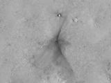
Impact Scars from MSL Cruise Stage and Two Balance Weights (Figure 1)
This map shows where NASA's Mars rover Curiosity has driven since landing at a site subsequently named "Bradbury Landing," and traveling to an overlook position near beside "Point Lake," in drives totaling 1,703 feet (519 meters).
Curiosity Rover's Traverse, August through November 2012
A regional dust storm visible in the southern hemisphere of Mars in this nearly global mosaic of observations made by the Mars Color Imager on NASA's Mars Reconnaissance Orbiter on Nov. 25, 2012.
Regional Dust Storm Weakening, Nov. 25, 2012
This nearly global mosaic of observations made by the Mars Color Imager on NASA's Mars Reconnaissance Orbiter on Nov. 18, 2012, shows a dust storm in Mars' southern hemisphere.
Martian Dust Storm, Nov. 18, 2012
This 3D, or stereo anaglyph, view shows NASA's Mars rover Curiosity where it landed on Mars within Gale Crater, at a site now called Bradbury Landing.
Curiosity at Bradbury Landing Site in 3D
This 3D, or stereo anaglyph, view shows the parachute and back shell that helped guide NASA's Curiosity to the surface of Mars.
Parachute and Back Shell in 3D
This 3D, or stereo anaglyph, view shows the upcoming science destination for NASA's Mars rover Curiosity, a region dubbed "Glenelg," where three different types of material seen from orbit come together (middle of picture).
'Glenelg' in 3D
This map shows the route driven by NASA's Mars rover Curiosity through the 56th Martian day, or sol, of the rover's mission on Mars (Oct. 2, 2012).
Curiosity's Travels Through Sol 56
This image shows the topography, with shading added, around the area where NASA's Curiosity rover landed on Aug. 5 PDT (Aug. 6 EDT).
Where Water Flowed Downslope
This map shows the path on Mars of NASA's Curiosity rover toward Glenelg, an area where three terrains of scientific interest converge.
Curiosity's Roadside Discoveries
This map shows the route driven by NASA's Mars rover Curiosity through the 43rd Martian day, or sol, of the rover's mission on Mars (Sept. 19, 2012).
Curiosity Traverse Map Through Sol 43
Observations by NASA's Mars Reconnaissance Orbiter have detected carbon-dioxide snow clouds on Mars and evidence of carbon-dioxide snow falling to the surface.
Carbon-Dioxide Snowfall on Mars
This map shows the route driven by NASA's Mars rover Curiosity through the 29th Martian day, or sol, of the rover's mission on Mars (Sept. 4, 2012).
Curiosity Traverse Map Through Sol 29
This color view of the parachute and back shell that helped deliver NASA's Curiosity rover to the surface of the Red Planet was taken by the High-Resolution Imaging Science Experiment (HiRISE) camera on NASA's Mars Reconnaissance Orbiter.
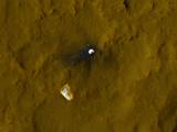
Relics of Rover's Landing
Tracks from the first drives of NASA's Curiosity rover are visible in this image captured by the High-Resolution Imaging Science Experiment (HiRISE) camera on NASA's Mars Reconnaissance Orbiter.
A Rover's Journey Begins
Details such as the shadow of the mast on NASA's Mars rover Curiosity appear in an image taken Aug. 17, 2012, by the High Resolution Imaging Science Experiment (HiRISE) camera on NASA's Mars Reconnaissance Orbiter, from more directly overhead than previous HiRISE images of Curiosity.
Orbiter View of Curiosity From Nearly Straight Overhead
1   |  2   |  3   |  4   |  5   |  6   |  7   |  8   |  9   |  10   |  11   |  12   |  13   |  Next >     Last Page >>

USA.gov
PRIVACY     FAQ     SITEMAP     FEEDBACK     IMAGE POLICY