Syndicate content

Blog Category: National Hurricane Center

NOAA Provides Easy Access to Historical Hurricane Tracks

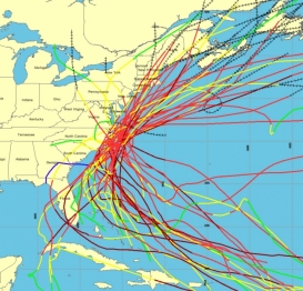
Map of U.S. with storm and hurricane trackings

Understanding historical hurricane landfalls is important in preparing for current storms

Seeing where hurricanes have hit and how often is one of the best ways to bring home a powerful hurricane preparedness message. A NOAA website, Historical Hurricane Tracks, lets users insert their zip code and see a map that contains more than 150 years of Atlantic hurricane tracking data. The site also contains global hurricane data from as far back as 1842.

“Knowing more about local hurricane history can help communities better understand their vulnerabilities so they can take steps to be more resilient if a future hurricane strikes.” says David Eslinger, Ph.D., an oceanographer with the NOAA Coastal Services Center and one of the site’s developers.

The Historical Hurricane Tracks website, http://www.csc.noaa.gov/hurricanes, includes tropical cyclone data and information on coastal county hurricane strike data through 2011 while also providing links to detailed reports on the life history and effects of U.S. tropical cyclones since 1958.

In addition to the tracks of storms, the site provides insight to the increasing numbers of the U.S. citizens and infrastructure at risk for hurricanes, detailing population changes for U.S. coastal counties from 1900 to 2000. As the population continues to grow, so too has the number of storms with multi-billion dollars in damages to coastal infrastructure and property. Seven of the top 10 costliest hurricanes in U.S. history have occurred in the past eight years, including seventh-ranked Irene last August with $15.8 billion in damages.

The site’s popularity with the public was evident as Hurricane Irene bore down on the U.S. East Coast. Tens of thousands of people used Historical Hurricane Tracks to compare the National Hurricane Center’s projected path of Irene with past storms. User traffic peaked at over 19,000 visits on August 26, the same day Irene swirled off the North Carolina coast heading towards New York City while saturating the East Coast and New England and leaving millions without power.

Acting Secretary of Commerce Rebecca Blank Urges Hurricane Preparedness

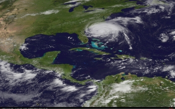
NOAA satellite image of Hurricane Irene (NOAA photo, Aug. 26)

As you know, Hurricane Irene is making its way up the East Coast of the United States. Make no mistake: This is a large and destructive storm and needs to be taken seriously, especially by the millions of people who live, work or travel in Irene’s projected path. 

Time is quickly running out for people to make emergency preparations and move out of harm’s way.

According to our meteorologists at Commerce/NOAA’s National Hurricane Center, Irene will approach the coast of North Carolina tonight, then move north and affect the mid-Atlantic and Northeast. Irene is a large storm and its high winds and heavy rain will affect a large area. Hurricanes like Irene are capable of causing other serious and life-threatening hazards, such as coastal surges, inland flooding and tornadoes. 

We strongly urge all affected Commerce employees and their families to finalize their preparations, so that they can meet their basic needs for a minimum of 72 hours. Visit FEMA’s preparedness sites www.ready.gov or www.listo.gov for tips on how you can make an emergency kit and put an emergency plan in place.

To follow the latest on Hurricane Irene, please visit NOAA’s National Hurricane Center on the Web at www.nhc.noaa.gov/#IRENE and on Twitter at www.twitter.com/NHC_Atlantic. Monitor local media or listen to NOAA Weather Radio for the latest developments and check your local National Weather Service forecast at www.weather.gov.  We also encourage you to consult our Tropical Cyclone Preparedness Guide.

Moreover, please heed the direction of your local officials, and be sure to know your evacuation route in case evacuation orders are given. 

Should you need to seek higher ground or take cover, shelters in North Carolina and other states are being prepared along the East Coast. You can find more information about open Red Cross shelters at www.redcross.org

We’re ready. Please be ready, too.

Commerce and NOAA have been actively mobilizing: Our National Hurricane Center meteorologists have been issuing forecasts, watches and warnings to the media, emergency managers and the public. At the same time, we’re also preparing to respond if necessary to Irene’s aftermath when National Weather Service local forecast offices will issue a variety of severe weather alerts for inland high winds, flooding and severe weather, including tornadoes. 

The larger federal government family is aggressively preparing for two phases of this operation–response and recovery–and has teams and assets moving into all of the states/regions across the East Coast that will be impacted by Hurricane Irene. We are continuing to do everything we can to support the governors and their teams.

On a final note, I want to thank all the NOAA staff who have been working hard this week to ensure that Americans have the most accurate and timely storm updates, watches and warnings—as well as those who will be working through the weekend and coming days to see this storm through and assist in the response phase. Your service to Commerce and the nation is deeply appreciated.

NHC'S Bill Read: A Hurricane by Any Other Name. . . .

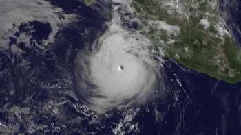
Satellite photo of Hurricane Dora, July21,  2011

Guest blog by Bill Read, Director of NOAA's National Hurricane Center

One of the customs of my job as Director that has been most interesting is the practice of naming of tropical cyclones. For several hundred years, many hurricanes in the West Indies were named after the particular saint's day on which the hurricane occurred. Ivan R. Tannehill describes in his book, Hurricanes the major tropical storms of recorded history and mentions many hurricanes named after saints. For example, there was Hurricane "Santa Ana," which struck Puerto Rico with exceptional violence on July 26, 1825, and "San Felipe" (the first) and "San Felipe" (the second) which hit Puerto Rico on September 13 in both 1876 and 1928.

Prior to the current naming scheme, storms were identified mostly by the current position (latitude and longitude). Not all of us are geographically oriented, and experience shows that the use of short, distinctive given names in written as well as spoken communications is quicker and less subject to error than the older more cumbersome latitude-longitude identification methods. In the pre-Internet, 24/7 news cycle era, these advantages were important in exchanging detailed storm information between hundreds of widely scattered stations, coastal bases and ships at sea.

While not officially adopted until after 1950, the use of common people names dates back to the last century. An early example of the use of a woman's name for a storm (a winter storm called “Maria”) was in the novel Storm, by George R. Stewart, published by Random House in 1941, also filmed by Walt Disney. During World War II, this informal naming practice became widespread in weather map discussions among forecasters, especially Air Force and Navy meteorologists who plotted the movements of storms over the wide expanses of the Pacific Ocean.

NOAA's Atlantic Hurricane Season Update Calls for Increase in Named Storms

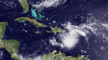
Satellite photo of Emily as of 8-3-11

Forecasters have a higher confidence for an active season

The Department of Commerce's National Oceanic and Atmospheric Administration (NOAA) issued its updated 2011 Atlantic hurricane season outlook today raising the number of expected named storms from its pre-season outlook issued in May. Forecasters also increased their confidence that 2011 will be an active Atlantic hurricane season. NOAA’s Climate Prediction Center, a division of the National Weather Service, updates its Atlantic hurricane season outlook every August.

“The atmosphere and Atlantic Ocean are primed for high hurricane activity during August through October,” said Gerry Bell, Ph.D., lead seasonal hurricane forecaster at the Climate Prediction Center.  “Storms through October will form more frequently and become more intense than we’ve seen so far this season.”

Key climate factors predicted in May continue to support an active season. These include: the tropical multi-decadal signal, which since 1995 has brought favorable ocean and atmospheric conditions, leading to more active seasons; exceptionally warm Atlantic Ocean temperatures (the third warmest on record); and the possible redevelopment of La Niña.  Reduced vertical wind shear and lower air pressure across the tropical Atlantic also favor an active season.

Based on these conditions and on climate model forecasts, the confidence for an above-normal season has increased from 65 percent in May to 85 percent. Also, the expected number of named storms has increased from 12-18 in May to 14-19, and the expected number of hurricanes has increased from 6-10 in May to 7-10. Read NOAA's full release

NOAA Hurricane Outlook Indicates an Above-Normal Season

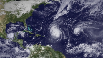
Hurricanes Karl, Igor and Julia

Urges residents in hurricane-prone areas to be prepared

The Atlantic basin is expected to see an above-normal hurricane season this year, according to the seasonal outlook issued by NOAA’s Climate Prediction Center – a division of the National Weather Service.

Across the entire Atlantic Basin for the six-month season, which begins June 1, NOAA is predicting the following ranges this year:

  • 12 to 18 named storms (winds of 39 mph or higher), of which:
  • 6 to 10 could become hurricanes (winds of 74 mph or higher), including:
  • 3 to 6 major hurricanes (Category 3, 4 or 5; winds of 111 mph or higher)

Each of these ranges has a 70 percent likelihood, and indicate that activity will exceed the seasonal average of 11 named storms, six hurricanes and two major hurricanes.

Now is the time to get your plan together for what you and your family would do if disaster strikes. Visit ready.gov to learn more and if you’re a small business owner, visit www.ready.gov/business to ensure that your business is prepared for a disaster.

Hurricane impacts are not limited to the coastline; strong winds and flooding rainfall often pose a threat across inland areas along with the risk for tornadoes.

Next week, May 22-28, is national Hurricane Preparedness Week. To help prepare residents of hurricane-prone areas, NOAA is unveiling a new set of video and audio public service announcements featuring NOAA hurricane experts and the FEMA administrator that are available in both English and Spanish. These are available at http://www.hurricanes.gov/prepareRelease 

NOAA Provides Easy Access to Historical Atlantic Hurricane Tracks

Website provides storm paths by ZIP code; includes population trends, storm history

Graphic from NOAA's Historical Hurricane Tracks tool shows all hurricanes passing within 65 nautical miles of Cape Hatteras, N.C., since 1900.An updated NOAA website lets everyone from reporters to city planners track local historical storm activity, review specific storm tracks and obtain information about a particular storm’s landfall. NOAA’s Historical Hurricane Tracks website and mapping application generates customized, downloadable maps based on more than 150 years of Atlantic hurricane data.

The Historical Hurricane Tracks tool, developed by NOAA’s Coastal Services Center in partnership with the National Hurricane Center, allows users to search by U.S. ZIP code, state or county, storm name or year, or latitude and longitude points. With the search results, users can generate a map showing the storm track accompanied by a table of related information.  Read more  |  Larger graphic