 Move mouse over image above to view 75Ma to 1 Ma animation
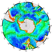
Bathymetry at Present
|
Construction of Circum-Antarctic Paleobathymetry to 30° South - Present to 75my
Electronic supplement to:
Hayes, D.E., C. Zhang and R.A. Weissel (2009),
Modeling Paleobathymetry in the Southern Ocean. Eos, Vol. 90, No. 19, 12 May 2009, p. 165-166.
Please cite the reference above when using these data.
Contact the authors for questions or electronic copies of the paper.
SUMMARY A software package has been developed to model the paleobathymetry of the circum-Antarctic oceans back to the Late Cretaceous. The package is based on a revised tectonic model of the circum-Antarctic region and incorporates a number of features such as spatially variable subsidence rates, refined rotation poles and a detailed treatment of selected areas. The output consists of color-coded maps at user-specified Cenozoic ages and the associated gridded paleobathymetry for all oceans lying south of 30°S.
METHODOLOGY We approximate the composite effects of sedimentation through loading and burial while assuming a constant sedimentation rate at each grid point. Our model differs from that of Brown, et al., 2006, in that we do not assume uniform cooling-induced subsidence throughout the entire region being modelled.
TECHNIQUE There are numerous steps involved in reconstructing paleobathymetry for any specified time. First, plates are rotated back to their position at the target time and oceanic crust younger than the target age is removed. Next, the residual present-day bathymetry must be adjusted to account for the effects of crustal subsidence, sedimentation and eustatic sea level changes. In some places, crust that existed at the target age has since been subducted and must be resurrected.
The user may accept our default parameters or enter new values at runtime for parameters such as subsidence. The user may also alter basic input data such as bathymetry, crustal age, sediment thickness and stage poles by creating new files. See Appendix A for the required file formats.
DATA SOURCES The Antarctic Paleobathymetry project draws heavily on the Marine Geophysical Atlas of the Circum-Antarctic to 30° S (Hayes, 1991) and NGDC digital databases: Bathymetry data - global databases ETOPO2 and ETOPO5 (NGDC); Crustal age data - Mueller (1998, v 1.3); Sediment Isopachs: Circum-Antarctic to 30°S (Hayes and LaBrecque 1991); Tectonics and Age of the Oceanic Crust: Circum-Antarctic to 30°S (Hayes, 1991).
Appendix A (PDF): Table I describes each Region, using the Region Number shown on the Tectonic Regions image on this page. The Stage Pole files are listed in Table II and are available as digital files accessed through this web page.
Appendix B (PDF), parts 1 & 2: Includes a description of input and output file formats and Table III, a comprehensive reference to plates, regions, program modues and reconstruction data files.
Appendix C (PDF): A processing overview and schematic diagram explaining modifications available to the user.
Additional files:
- Images of Calculated Paleobathymetry :
Image files are available for ages 1-10Ma in 1 my increments, and 10 - 75Ma in 5my increments.
- Image Files of Input Data used: Bathymetry, crustal ages, sediment thickness, and plates and regions are shown in polar stereographic projection.
- Stage Pole files:
files containing the stage poles required to rotate each plate through time. (text)
- Basefiles: These contain the bathymetry, crustal age and sediment thickness data at zero-age (Present) needed to process each geographic region. (text or binary)
- Subsidence Rate (Cooling) and Sealevel files : Easily modified text files specify the subsidence and sealevel history to be applied to each region.
|
|


