|
NWS Burlington Winter Weather Page
|
Current Radar & Satellite Images |
Montague Radar
![Current Montague Radar - Click to Enlarge](https://webarchive.library.unt.edu/web/20130309184240im_/http://www.erh.noaa.gov/radar/images/DS.p19r0/SI.ktyx/latest.gif)
|
Burlington Radar
![Current Burlington Radar - Click to Enlarge](https://webarchive.library.unt.edu/web/20130309184240im_/http://www.erh.noaa.gov/radar/images/DS.p19r0/SI.kcxx/latest.gif)
|
Visible Satellite
![Current Visible Satellite](https://webarchive.library.unt.edu/web/20130309184240im_/http://www.ssd.noaa.gov/goes/east/nwatl/vis-l.jpg)
Loop It
|
Infrared Satellite
![Current Infrared Satellite - Click to Enlarge](https://webarchive.library.unt.edu/web/20130309184240im_/http://www.ssd.noaa.gov/goes/east/nwatl/rb-l.jpg)
Loop It
|
Current Weather
|
Today's Weather
|
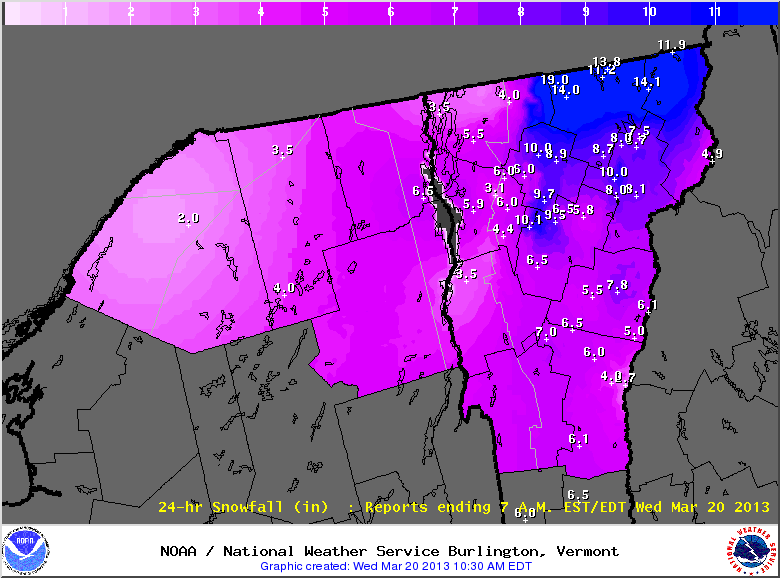
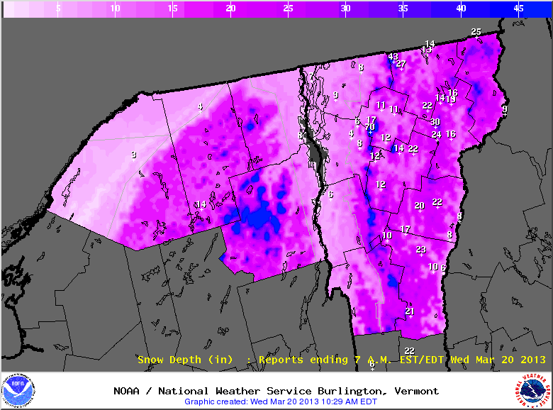
Storm Total Snowfall Graphics |
Storm Total Snowfall graphics are only updated during active watches, warnings, and advisories for snowfall events
|
0 - 36 Hour Snowfall Graphics |
0 - 6 Hour
![0-6 Hour Snowfall Graphic](https://webarchive.library.unt.edu/web/20130309184240im_/http://www.erh.noaa.gov/ndfd/graphical/images/btv/SnowAmt1_btv.png)
|
6 - 12 Hour
![6-12 Hour Snowfall Graphic](https://webarchive.library.unt.edu/web/20130309184240im_/http://www.erh.noaa.gov/ndfd/graphical/images/btv/SnowAmt2_btv.png)
|
12 - 18 Hour
![12-18 Hour Snowfall Graphic](https://webarchive.library.unt.edu/web/20130309184240im_/http://www.erh.noaa.gov/ndfd/graphical/images/btv/SnowAmt3_btv.png)
|
18 - 24 Hour
![18-24 Hour Snowfall Graphic](https://webarchive.library.unt.edu/web/20130309184240im_/http://www.erh.noaa.gov/ndfd/graphical/images/btv/SnowAmt4_btv.png)
|
24 - 30 Hour
![24-30 Hour Snowfall Graphic](https://webarchive.library.unt.edu/web/20130309184240im_/http://www.erh.noaa.gov/ndfd/graphical/images/btv/SnowAmt5_btv.png)
|
30 - 36 Hour
![30-36 Hour Snowfall Graphic](https://webarchive.library.unt.edu/web/20130309184240im_/http://www.erh.noaa.gov/ndfd/graphical/images/btv/SnowAmt6_btv.png)
|
|
|