New England Water Science Center - Connecticut Office
 Installing a Storm Surge-Sensor for Hurricane Sandy DATA CENTER
CONNECTICUT PROJECTS
INFORMATION CENTER
ABOUT THE Connecticut OfficeUSGS IN YOUR STATEUSGS Water Science Centers are located in each state. 
|
Water Resources of ConnecticutUSGS to Discontinue Streamgages Due to Sequestration: The U.S.Geological Survey (USGS) will discontinue operation of up to 375 streamgages nationwide due to budget cuts as a result of sequestration. Additional streamgages may be affected if partners reduce their funding to support USGS streamgages. The USGS is working to identify which streamgages will be impacted and when, and will post this information as it becomes available. Streamgages are used nationwide to predict and address drought and flood conditions by monitoring water availability. The USGS and over 850 Federal, State, and local agencies cooperatively fund the USGS streamgaging network, which consists of over 8,000 streamgages. When budget fluctuations occur, the network is impacted. For more information contact Virginia de Lima at 860-291-6741 or vdelima@usgs.gov. Welcome to the USGS New England Water Science Center, Connecticut Office. These pages are your source for water-resource information collected and interpreted by the U.S. Geological Survey in Connecticut. Current Streamflow Conditions Maps USGS sends email response with real-time stream stage and flow data for the USGS station (site) number in subject line of your email request. iNWS provides text messaging alerts from the National Weather Service for weather and hydrology. In the SpotlightUSGS work in the Connecticut River Basinhttp://ct.water.usgs.gov/Blueways-USGS.pdf Connecticut StreamStats.
WiM Hurricane Irene mapper tracks storm surge and flooding
Hurricane Sandy Links
NWIS Mapper
SPARROW Decision Support Tool
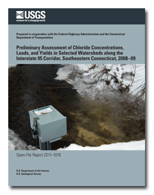
Featured ProjectsEvaluation of the Effects of Sewering on Nitrogen Loads to the Niantic River, Connecticut Areal view of Pine Grove, Connecticut The Niantic River Basin is a developed coastal basin (28 mi2) in Connecticut underlain by glacial stratified deposits in the valley bottom, and glacial till over bedrock in upland areas. Currently, the Niantic River is the first embayment where eelgrass is present in Long Island Sound, when moving from west (New York City Area) to east. Therefore, the Niantic River is currently thought to have marginal water quality with respect to eelgrass habitat Assessment of Chloride in Watersheds along I-95, Southeastern Connecticut Taking samples back for analysis The USGS is conducting a 3-yr monitoring program in cooperation with the Federal Highway Association (FHWA) and the Connecticut Department of Transportation (ConnDOT) to determine chloride concentrations and loads from streams that intersect I-95. Chloride, temperature, and specific conductance are measured upstream and downstream of I-95 at four watersheds in southeastern Connecticut -- Four Mile River, Oil Mill Brook, Stony Brook, and Jordan Brook. Highlighted PublicationsThe Connecticut Water Science Center produces publications about water resources.
|

![]() U.S. Department of the Interior |
U.S. Geological Survey
U.S. Department of the Interior |
U.S. Geological Survey
URL: http://ct.water.usgs.gov/index.htm
Page Contact Information: CT Webmaster
Page Last Modified: Wednesday, 20-Mar-2013 15:51:50 EDT