Florida Water Science Center
ABOUT FLORIDA SCIENCE
DATA CENTER
SCIENCE WEBSITESOFFICESOrlando - 407-803-5500 |
United States Geological Survey (USGS): Water Resources of FloridaThe mission of the Water Discipline, which supports the overall mission of the U.S. Department of the Interior and the U.S. Geological Survey, is to provide the hydrologic information and understanding needed for the best use and management of the Nation's water resources for the benefit of the people of the United States. The USGS provides current ("real-time") stream stage and streamflow, water-quality, and groundwater levels for sites in Florida. The NWIS Mapper is available to display active and historical station locations with links to their available data. USGS Florida Science HighlightsCarbonate Aquifer Characterization Laboratory
Gages Remain UnfundedNotice: (March 8, 2013)-- USGS to Discontinue Streamgages Due to Sequestration The U.S. Geological Survey (USGS) will discontinue operation of up to 375 streamgages nationwide due to budget cuts as a result of sequestration. Additional streamgages may be affected if partners reduce their funding to support USGS streamgages. The USGS is working to identify which streamgages will be impacted and will post this information as it becomes available. Streamgages are used nationwide to predict and address drought and flood conditions by monitoring water availability. The USGS and over 850 Federal, State, and local agencies cooperatively fund the USGS streamgaging network, which consists of over 8,000 streamgages. When budgets fluctuations occur, the network is impacted. Budget shortfalls at all levels of government have caused reductions in the amount of hydrologic data collected in Florida. As of October 1, 2011, 313 USGS stream, lake, rainfall, water quality, and groundwater monitoring sites have been discontinued, and there are 18 sites scheduled to be discontinued between March 31 and September 30, 2013 unless alternate sources of funding are identified. For a map of discontinued sites, go to Florida discontinued stations. Although historic data for these sites will remain accessible through this web site, no new data will be collected by the USGS. For some sites, data collection has been taken over by other agencies and new data may be available through them. If you have questions about any of these stations, please contact Richard Kane of the USGS Florida Water Science Center (813-498-5057, rkane@usgs.gov). Florida WeatherRecent Publications
USGS WaterAlert
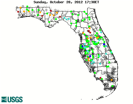
Florida WaterWatchMaps Deliver Current Streamflow Conditions
The maps utilize zoom and pan to allow you to focus in on the water-monitoring sites that interest you. Maps and data about current and past streamflow, floods, and drought are available. |

![]() U.S. Department of the Interior |
U.S. Geological Survey
U.S. Department of the Interior |
U.S. Geological Survey
URL: http://fl.water.usgs.gov/
Page Contact Information: Webmaster
Page Last Modified: 07:27:05 Fri 08 Mar 2013