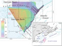
U.S. and Canadian Geologists Collaborate in Mapping the Georges Bank Seabed
Nov. / Dec. 2012
Sea-Level Rise Accelerating on U.S. Atlantic Coast
Sept. / Oct. 2012
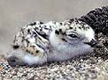
Hawaiian Seabirds on Low-Lying Atoll Vulnerable to Sea-Level Rise
Sept. / Oct. 2012
Corals Damaged in the Deep Gulf of Mexico by Deepwater Horizon Oil Spill
Sept. / Oct. 2012
Gulf Coast Vulnerable to Extreme Erosion During Category 1 Hurricanes—New Model to Help Community Planners, Emergency Managers
Sept. / Oct. 2012
Gas Hydrates and Climate Warming—Why a Methane Catastrophe Is Unlikely
May / June 2012
Real-Time Mapping of Seawater and Atmospheric Methane Concentrations Offshore of Alaska's North Slope
May / June 2012
Coastal and Marine Geoscience Data System—Single Point of Access for Digital Geophysical and Lidar Data of the USGS Coastal and Marine Geology Program
May / June 2012
Exploring USGS Coastal and Marine Geophysical Data Using GeoMapApp and Virtual Ocean: Tools for Integrating Earth-Science Data
May / June 2012
Maps Based on Satellite Telemetry Help Russian Tanker Avoid Threatened Sea Ducks During First Maritime Fuel Delivery to Western Alaska Through Sea Ice
Mar. / Apr. 2012
Severe Declines in Everglades Mammals Linked to Pythons
Mar. / Apr. 2012
How Often Do Sediments on the Seafloor Move?
Mar. / Apr. 2012
Coral Reef Disease Hits Kane'ohe Bay, Hawai'i
Jan. / Feb. 2012
Flash Forward 100 Years: Climate Change Scenarios in California's Bay-Delta
Jan. / Feb. 2012
Science in Support of Everglades Restoration—Some Contributions from the USGS in Florida
Nov. / Dec. 2011
International Team Studies Impacts of Oil and Gas Drilling on Cold-Water Corals in Norway
Sept. / Oct. 2011
Significant Natural Gas Resources Remain to Be Discovered in Cook Inlet, Alaska
Sept. / Oct. 2011
U.S. West Coast Erosion Spiked In Winter 2009-10, Previewing Likely Future As Climate Changes
August 2011
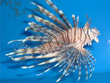
Extent and Speed of Lionfish Spread Unprecedented—Invasive Marine Fish May Stress Reefs
June 2011
Life in San Francisco Bay Influenced by Factors Far Out at Sea
June 2011
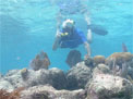
Coral Reef Health and Environmental Changes in the Florida Keys and the Caribbean Sea - Video Podcasts Highlight USGS Research
April / May 2011
Palmyra Atoll: An Island Paradise In Recovery
April / May 2011
Japan Lashed by Powerful Earthquake, Devastating Tsunami
March 2011
Long-Lived, Slow-Growing Corals in Deep Waters of the Gulf of Mexico
March 2011
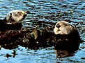
USGS Analyzing Sea Otter Death Data
March 2011
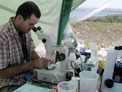
CO2calc - a User-Friendly Seawater-Carbon Calculator for Windows, Mac OS X, and iOS (iPhone) - Will Assist Studies of Ocean Chemistry
March 2011
Projected Losses of Arctic Sea Ice and Polar Bear Habitat May Be Reduced if Greenhouse-Gas Emissions are Stabilized
Jan. / Feb. 2011
ARkStorm: California's Other "Big One"
Jan. / Feb. 2011
Many Coastal Wetlands Likely to Disappear This Century
Jan. / Feb. 2011
Unlocking Oceans of Model Data via Web Services
December 2010
Whale Falls
Oct. / Nov. 2010
A New Understanding of 31 Years of Chesapeake Bay Nutrient Trends
Oct. / Nov. 2010
Manatee Subspecies Genetically Confirmed, But Diversity Challenge Looms
Oct. / Nov. 2010
Dry Tortugas National Park: a Unique Setting for USGS Marine Research
Aug. / Sept. 2010
Coral Records of Sediment Input to the Fringing Reef of Moloka'i Hawai'i
Aug. / Sept. 2010
Nile Delta Natural-Gas Potential is Significant
July 2010
Past Decade of Extreme Storms Leaves Coasts Vulnerable
May / June 2010
Climate-Change Impacts on Wildlife Will Be Studied: Fish and Wildlife Face Significant Risks as the Climate Changes
May / June 2010
Natural-Gas Potential Assessed in Eastern Mediterranean
May / June 2010
Discovering the Secret Gardens in the Mangroves of St. John, U.S. Virgin Islands
April 2010
The 2010 Chilean Tsunami and Uncertainty in Tsunami Modeling
April 2010
Ice Shelves Disappearing on the Antarctic Peninsula—Glacier Retreat and Sea-Level Rise Are Possible Consequences
April 2010
USGS Launches Multidisciplinary Investigation of Northeast Pacific Sea Otter Populations and Nearshore Ecosystems
March 2010
USGS Sediment-Transport Investigators Calibrate Tripod-Mounted Underwater Sonars in a Large Tank at the University of New Hampshire
March 2010
Peace River in Florida Loses as Much as 11 Million Gallons a Day to Sinkholes and is Vulnerable to Running Dry
Jan. / Feb. 2010
New Discoveries About the Deep Ocean Could Improve Climate Projections
Jan. / Feb. 2010
Arctic Could Face Warmer and Ice-Free Conditions
Jan. / Feb. 2010
Samoa Disaster Highlights Danger of Tsunamis Generated from Outer-Rise Earthquakes
December 2009
Saving Sand: South Carolina Beaches Become a Model for Preservation
December 2009
Remote-Sensing Technologies Provide Unique Maps and Datasets to Support Coastal Scientists, Managers, and Decision Makers
October 2009
What Science Says About Beach Sand and Stomach Aches
September 2009
Landmark Study Demonstrates How Methylmercury, Known to Contaminate Seafood, Forms in the Ocean
August 2009
Spring 2009 Nutrient Delivery to the Gulf of Mexico Above 30-Year Average
August 2009
Assessing Offshore Marine Sand Deposits with Probabilistic Models
June / July 2009
Elevated Atmospheric CO2 May Help Coastal Wetlands Keep Pace with Sea-Level Rise
May 2009
Erosion Doubles Along Part of Alaska's Arctic Coast—Cultural and Historical Sites Lost
May 2009
The Shrinking Beaufort Sea Coastline
May 2009
New USGS Study Documents Rapid Disappearance of Antarctica's Ice Shelves
May 2009
Ecologists Question Effects of Climate Change on Infectious Diseases
May 2009
Recovery of Shorebird May Require Further Restrictions on Bait Use of Horseshoe Crabs
April 2009
Food Choices and Location Influence California Sea Otter Exposure to Disease
March 2009
Getting Warmer? Prehistoric Climate Can Help Forecast Future Changes
Jan. / Feb. 2009
Silent Streams? Escalating Endangerment for North American Freshwater and Diadromous Fish: Nearly 40 Percent Now At Risk
Jan. / Feb. 2009
Most Alaskan Glaciers Retreating, Thinning, and Stagnating, Says Major USGS Report
December 2008
Genetics Provides Evidence for the Movement of Avian Influenza Viruses from Asia to North America via Migratory Birds
December 2008
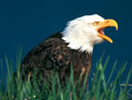
Alaska's Sea-Otter Decline Affects Health of Kelp Forests and Diet of Eagles
November 2008
Slowing of Coastal Subsidence Is Good News for Restoration of Louisiana's Wetlands
October 2008
Study Shows Parasites Outweigh Predators
October 2008
Research on Whitings (Floating Patches of Calcium Carbonate Mud) Leads to Possible Explanation of Immense Middle East Oil Deposits
July 2008
Passing the Torch_Water-Quality Monitoring by the USGS and the Yukon River Inter-Tribal Watershed Council
June 2008
New Method to Estimate Sea-Ice Thickness
June 2008
Sea-Otter Study Reveals Striking Variability in Diets and Feeding Strategies
May 2008
Coral-Reef Builders Vulnerable to Ocean Acidification
March 2008
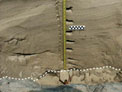
Distinguishing Tsunami from Storm Deposits in the Geologic Record
November 2007
Mercury Contamination in Waterbirds Breeding in San Francisco Bay
October 2007
Newly Dis0ed Fossil Sponges Share Scientific Secrets About Miami's Ancient Marine Environment
July 2007
Real-Time Water Data via Satellite Telemetry in Florida
June 2007
Beam Time at the Stanford Linear Accelerator Awarded to USGS Scientist
May 2007
Tar Balls Washed Onto Central California Beaches by Storms
May 2007
Deadly Tsunami Hits Solomon Islands
April 2007
Tsunami-Forecasting System Tested by Recent Subduction-Zone Earthquakes
April 2007
Sub-Sea-Floor Methane in the Bering Sea—USGS Emeritus Describes Possible Gas-Hydrate Accumulations to the Geophysical Society of Alaska
April 2007
Discovering the Effects of CO2 Levels on Marine Life and Global Climate
Jan. / Feb. 2007
Portable Underwater Photographic Tripod for Coral-Reef Studies
Jan. / Feb. 2007
Giant Underwater Sand Waves Seaward of the Golden Gate Bridge
September 2006
Manatee Traveler in Northeastern Waters Not Chessie
September 2006
Cat Parasite May Affect Cultural Traits in Human Populations
September 2006
Lake Whitefish Returning to the Detroit River to Spawn; Federal Scientists Document First Reproducing Population of Whitefish in the River Since 1916
August 2006
Parasites, the Thread of Food Webs?
August 2006
Scientists Go Deep to Track Algae-Feeding Nitrogen in Wahington State's Hood Canal
July 2006
Biologists Count Parasites to Assess Health of Marsh
July 2006
Researcher Follows Trail of Dust to Investigate Its Effects on Human and Coral Health
July 2006
Water Temperature Appears to Restrict Distribution of Juvenile Coho Salmon in Redwood Creek, California
July 2006
Limited Reproductive Success for California Clapper Rail in San Francisco Bay
June 2006
USGS Study of Nearshore Habitats to Aid Puget Sound Re0y Attracts Media Attention
June 2006
Release of usSEABED Offshore Sediment Data for the Atlantic Coast Region—a Tool for GIS Mapping and Research
May 2006
Scientists Recreate Ground Shaking from the 1906 San Francisco Earthquake
April 2006
USGS Report of Methane Hydrate Off Southern California Sparks Media Interest
March 2006
Abalones May Owe Their Huge Size to Sea Otters
February 2006
Study Shows That Urbanization Leads to Amphibian Declines in Southern California Coastal Watersheds
January 2006
Using Genetic Modeling to Assess the Health and Status of Manatee Populations
September 2005
Brief Tsunami Warning Startles U.S. West Coast, Reveals Strengths and Weaknesses in Tsunami Preparedness
July 2005
U.S. Geological Survey and the American Geological Institute Receive Valuable Seismic Data from Chevron Corp.
June 2005
Introduced Foxes Transformed Vegetation
May 2005
Making Waves and Ripples in a Giant Flume in Japan
April 2005
Recovery from Wildfire Is Slow for Point Reyes Mountain Beaver
April 2005
Dam Removal on the Elwha River in Washington—Nearshore Impacts of Released Sediment
February 2005
Coral Reef Off Florida Determined to be Deepest Known on U.S. Continental Shelf
February 2005
Raising Crane at Patuxent Wildlife Research Center
February 2005
USGS Scientist Studies Causes of Anomalous U.S. Hurricane Landfall Count in 2004
February 2005
Four Submarine Canyons on U.S. East Coast Named for Marine Geologists
January 2005
Seabirds off Southern California—Surveys Reveal Patterns in Abundance and Distribution
November 2004
How Suspended Organic Sediment Affects Turbidity and Fish Feeding Behavior
November 2004
USGS Monterey Bay Science: A Knowledge Bank Prototype
November 2004
Florida's Geology Makes Wastewater Disposal a Potential Threat to Ecosystem Health in the Florida Keys
October 2004
USGS Maps and Data Show Why the Gulf of Mexico's Eroding Shoreline is Vulnerable to Hurricanes
October 2004
Manatee Population Rising in Some Regions, Likely Stalled or Declining in Others
September 2004
Online Mapping Service for the Gulf of Maine
September 2004
West-Central Florida Coastal Studies Project Celebrates Successful Conclusion
July 2004
Coral Mucus Goes Mainstream—New Discoveries in Mucus-Hosted Microbial Communities
June 2004
Strategic Plan for Gulf of Maine Mapping Initiative
June 2004
Geologist Analyzes Soil Samples to Assist the Search for a Missing Person
June 2004
Submarine Ground-Water Discharge and Its Influence on Coastal Processes and Ecosystems
June 2004
Cooperative Study Notes Increased Occurrences of Infectious Disease in Our Oceans
May 2004
USGS Sedimentologist David Rubin Serves as External Expert During NASA Announcement of Evidence for Flowing Water on Mars
April 2004
Patent Awarded to USGS Scientists for Underwater Microscope System
March 2004
USGS and Academia in Partnership—Exploring the Use of Joint Fact Finding in Science-Intensive Disputes
February 2004
Threatened Snowy Plovers Make a Comeback on a Santa Barbara Beach, Thanks to a Public-Friendly, Award-Winning Program
January 2004
Ecological Repercussions of Ditching Wetlands for Mosquito Control in Tampa Bay, Florida, or "Fishes in Ditches"
January 2004
The 2003 Hokkaido Earthquake and Tsunami_Collaborative Research
November 2003
Collapsing Populations of Marine Mammals—the North Pacific's Whaling Legacy?
October 2003
Delivery of Sediment-Associated Contaminants to the Gulf of Mexico
June 2003
Nutrient Enrichment in Florida Springs
June 2003
Mapping Ecologically Sensitive Islands in the Bering Sea
May 2003
The "Poking Eyeball"—a Prototype Underwater Camera System
April 2003
Invaders Have Fewer Parasites, Giving Them a Competitive Edge Over Native Animals and Plants
Feb. / Mar. 2003
Lake Mead Work Continues, with Presentations and Sampling
Feb. / Mar. 2003
Diamondback Terrapin Still Vulnerable to Human Activities
January 2003
USGS Research Contributes to Assateague Island Restoration—Mitigating 70 Years of Coastal Erosion Due to Ocean City Inlet Jetties
November 2002
Group Aims to Distinguish Tsunami Deposits from Large-Storm Deposits in the Geologic Record
October 2002
Proposal for Drilling in the Broad, Shallow Seas of Southeast Asia and Australia
September 2002
African Dust Microbiology in the Caribbean
September 2002
Studies of Contaminated Ground Water Yield New Insights into Degradation of Diesel Fuel
August 2002
Parasites as Indicators of Coastal-Ecosystem Health
August 2002
Progress in Delineating Submarine Ground-Water Discharge in Delmarva Coastal Bays
June 2002
USGS Work Is Leading to New Operations for Glen Canyon Dam
June 2002
Teamwork Sheds Light on Shorebird-Migration Mysteries
May 2002
Carbon Dioxide Sequestration in Saline Aquifers
May 2002
Where Disease May Mean Good Health—The Role of Parasites in Natural Ecosystems
April 2002
What's Wrong with the California Sea Otter?
February 2002
USGS Assists in Training U.S. Fish and Wildlife Service Technical Staff on Geologic Processes in Coastal Ecosystems
September 2001
MRIB to Host Digital Library of Gulf of Maine
September 2001
USGS Patent Pending for a New Underwater Microscope System
June 2001
Hurricane Display at Department of Interior Headquarters in Washington, D.C.
June 2001
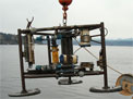
Oceanographic Instrumentation Recovery
May 2001
LaserMap—A Software Package Designed to Enable the Wide Application of Coastal Topographic Lidar Data
May 2001
New Publication Depicts Seafloor Rocks and Sediments of the Continental Shelf, Monterey Bay Area
February 2001
Gas-Hydrate Inventory on New Web Site
February 2001
Marine Realms Information Bank, A Web-Distributed Geo-Library for the Ocean
January 2001
Turning Point in Boston Harbor Clean-Up
October 2000
Seafloor Mapping Group Publishes First DVD-ROM
October 2000
Joint USGS/BRD/WRD Studies in the St. Petersburg Office
July 2000
Canadian SeaMap Program to Map Canadian Sea Floor and Lake Beds
July 2000
Barataria Barrier-Shoreline Feasibility Study
June 2000
Two New CMG Web Sites: A Wealth of Information on Tsunamis, and Virtual Flights Through Multibeam Mapping Data
March 2000
CMG/WRD Cooperative Research and Talks
January 2000
Sediment Database Design Nears Completion; Interest Invited
September 1999
New Mamala Bay Web Site Targets Both Researchers and the Public
September 1999
Collaboration Between USGS and University Benefits Both
August 1999
Rio Grande Delta in Texas—Sea-Level, Climate, Neotectonic and Anthropogenic Effects
May 1999
Venture Capital Award
May 1999