What is El Niño?
El Niño is defined as warmer than normal sea-surface temperatures (SSTs)
in the tropical Pacific ocean that impact global weather patterns. This deviation from normal
SSTs can have large scale impacts, not only on ocean processes, but also
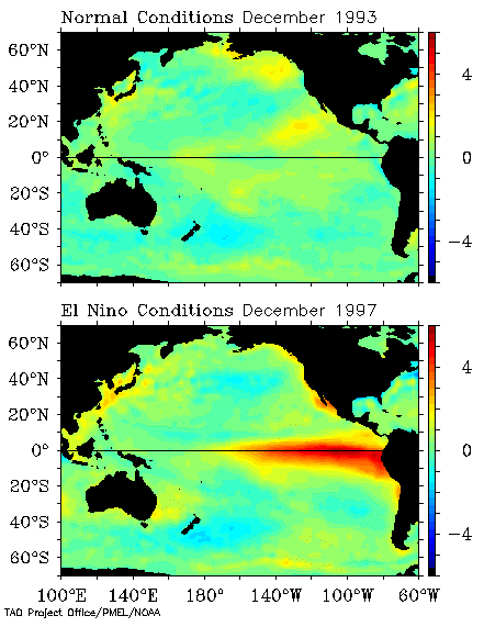
on the atmosphere. The graphic shown at the upper-left shows a normal SST pattern from December 1993, indicating
no large scale deviations in the SST pattern.
The bottom graphic shows the SST pattern from December 1997 which happened to be during
one of the largest El Niño events recorded during the 20th century. It is easy to see a large
broad area of red, centered on the equator over the eastern Pacific Ocean. This area of red denotes SSTs which are 2-6
degrees warmer than normal values at that time of year. This is the signal that scientists look for
when diagnosing El Niño events. As can be seen, the size of this warm pool of ocean water can be larger than the
entire United States!
So how does this large pool of warm water impact the atmosphere?
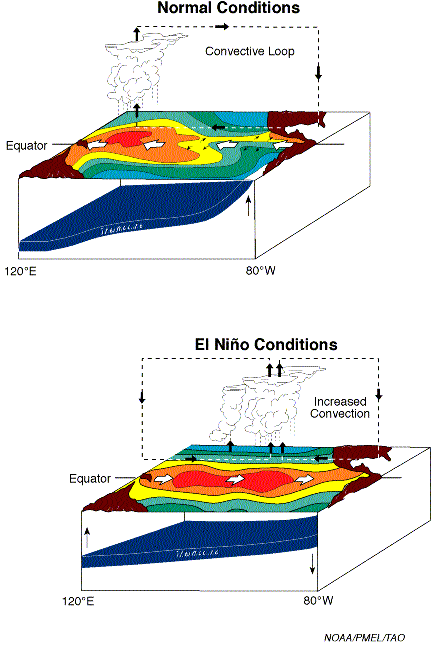
In normal, non-El Niño conditions (top panel of diagram to the left, land masses represented in brown),
the trade winds blow toward the west across the tropical Pacific Ocean. These winds pile up warm surface water in the
west Pacific, so that the sea surface is about 1/2 meter higher at Indonesia than at Ecuador.
The sea surface temperature is about 8 degrees C higher in the west, with cool temperatures off South America, due to
an upwelling of cold water from deeper layers. This cold water is nutrient-rich, supporting a diverse marine ecosystem and
major fisheries. Rainfall is found in rising air over the warmest water in the western Pacific, and the east Pacific is
relatively dry. The diagram shows the typical convective loop with rising air over the western Pacific and sinking
air over the eastern Pacific.
During El Niño (bottom panel of diagram to the left), the trade winds relax in the central and western Pacific
leading to a movement to the east of the warm pool of water. This warm pool of water moves eastward until it spreads across
the entire Pacific Ocean. The normally cool water located off the South American coast is replaced by much warmer
waters, and without the trade winds, the upwelling which supplies the cooler sub-surface ocean water is weakened. This leads to
the warm SSTs that were shown at the figure at the top of this webpage, with the strongest deviations from normal just off the
South American coastline. Rainfall follows the warm water eastward, with associated flooding in Peru and drought in the
normally wet regions of Indonesia and Australia. This eastward displacement of the atmospheric heat source overlaying
the warmest water results in large changes in the global atmospheric circulation pattern as can be seen in the diagram. This
large change in the circulation pattern in turn forces changes in weather in regions far removed from the tropical Pacific,
such as Arizona.
How did it get the name El Niño?
El Niño means The
Little Boy, or Christ Child in Spanish. This name was chosen based on the time of year in which the warm waters developed
off the South American coast. El Niño was originally recognized by fishermen off the coast of South America in the
1600s, with the appearance of unusually warm water in the Pacific Ocean. This phenomenon typically occurred near the
beginning of the year and meant that fishing would be more difficult due to the lack of nutrients brought up to the ocean
surface by upwelling. Since fishing villages depended on the fish that were caught by the fishermen, these episodes were
documented as harsh times for the villages due to lack of food and the prevalence of flooding rains.

What are the global impacts of El Niño?
As mentioned, El Niño has impacts that are felt not only near the equator, but far removed from the equator as
can be seen in the figure to the left. A large area of dry and warm conditions are found in normally wet regions of the world
such as Indonesia and Australia. Places that are normally dry, like western South America and the southwest United
States tend to be much wetter than normal. Western Canada and Alaska along with portions of the Midwestern United
States tend to enjoy a much warmer than normal winter as well. The southeast United States tends to experience
wet and cool conditions throughout much of an El Niño winter.
What about the impact of El Niño on northern Arizona?
The general effects of El Niño on northern Arizona tend to be felt most during the winter months. This
is due to the stronger jet stream that typically occurs during the winter, when the effects of the warmer pool
of water on the atmosphere are strongest. Across northern Arizona, El Niño winters tend to have more
prolonged story periods with fewer and shorter dry breaks than normal. The storm track tends to have fewer
storm systems originating from colder regions, and more originating from warmer regions with more moisture
associated with them. Because of this, El Niño winters tend to be warmer and wetter than a normal winter across
northern Arizona. For more information, please check out the Science Corner webpage called
How can El Niño and La Niña affect Arizona?
How often do El Niño events occur?
El Niño events tend to occur on average about every 3 to 5 years and typically last for a year. However, El
Niño events can last for two years on occasion. For a list of El Niño (warm) events, please go to the
Climate Prediction
Center List of Cold and Warm Episodes by Season.
How can I find out more about El Niño ?
Numerous webpages can be found on the internet with information regarding El Niño. Those links provided below
are only a few of the locations on the web where you can find more information regarding this ocean-atmospheric
phenomenon.
|


