Reducing Ship Strikes to North Atlantic Right Whales
|
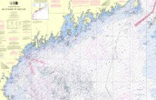
Active Mandatory 10-knot Speed Zones (SMAs)
|
|
|
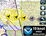
Voluntary 10-knot Speed Zones (DMAs)*  Southern New Jersey, in effect Feb 7-22, 2013 *Mariners are requested, but not required, to either avoid DMAs or travel through them at 10 knots or less. |
|
Maps
|
|
|


Background
With only about 400 in existence, North Atlantic right whales are among the most endangered whales in the world. Their slow movements, time spent at the surface, and time spent near the coast make them highly vulnerable human activities, especially being struck by ships.
- To report a ship strike, contact the NMFS Regional Stranding Coordinator in that area.
- Recent right whale sightings
Speed Restrictions
All vessels 65 ft (19.8 m) or longer must travel at 10 knots or less in certain locations (SMAs) [pdf] along the east coast of the U.S. Atlantic seaboard at certain times of the year to reduce the threat of ship collisions with critically endangered North Atlantic right whales.
- How Do I Comply? [pdf]
- Final Rule Federal Register Notice [pdf]
(Published 10/10/2008, 73 FR 60173) - Maps of Seasonal Management Areas [pdf]
- Free Interactive Guide for Commercial Mariners
- » More Information on Speed Restrictions
Vessel Routing
- Great South Channel Area to be Avoided (ATBA)
On June 1, 2009, a voluntary seasonal ATBA [pdf] was established for ships weighing 300 gross tons or more. The ATBA will be in effect each year from April 1 to July 31, when right whales face their highest risk of ship strikes in this area.
» More information on the ATBA
- Boston, MA: Traffic Separation Scheme (TSS)
On June 1, 2009, the North-South lanes of the TSS servicing Boston were modified to reduce the threat of vessel collisions with right whales and other whale species.
(1) This change narrows each of the lanes from 2 miles to 1.5 miles;
(2) The width of these lanes are now consistent with the East-West Boston TSS lanes; and
(3) The western boundary of the TSS remains unchanged. This modification moves ships away from the greatest density of right whales and thus minimizes the overlap between whales and ships.
(The TSS servicing Boston was first modified on July 1, 2007.)
» More information on the TSS
- Recommended Routes in Key Right Whale Habitats in FL, GA, and MA
In November 2006, NOAA established a set of recommended vessel routes in 4 locations to reduce the likelihood of ship collisions in key right whale habitats.
Report of Workshop on Technologies to Reduce Ship Strikes
In July 2008, NOAA Fisheries convened a Workshop to Identify and Assess Technologies to Reduce Ship Strikes of Large Whales [pdf]. The goals of the workshop were to:
- identify existing or emerging technologies that might be useful in reducing ship strikes
- assess the feasibility of each in reducing ship strikes
- identify research and development timelines needed to make a given technology useful in reducing the threat
More Information
- An Assessment of the Final Rule to Implement Vessel Speed Restrictions to Reduce the Threat of Vessel Collisions with North Atlantic Right Whales [pdf] (NMFS-OPR-48)
- North Atlantic Right Whales species information
- Mandatory Ship Reporting
- Right Whale Ship Strike Reduction in NOAA's Northeast Region
- Right Whale Conservation in NOAA's Southeast Region
- Serious/ Non-Serious Injury of Marine Mammals
- » Other Supporting/Background Information
Updated: February 7, 2013