Landsat Missions
Landsat Missions
 Pingo Wildfire, Alaska, USA Sensor: L7 ETM+ Path/Row: 70/13 Lat/Long: 67.202/-146.387 Category: Natural Disasters Download High Resolution |  Fire at Big Mountain, Alaska Sensor: L5 TM Path/Row: 64/13 Lat/Long: 66.900/-137.600 Category: Natural Disasters Download High Resolution Date Posted: 06/16/2010 |  Siberian Fires Sensor: L5 TM, L7 ETM+ Path/Row: 98/16 Lat/Long: 62.900/166.100 Category: Natural Disasters Download High Resolution Date Posted: 08/25/2010 |  Mt. Redoubt, Alaska, USA Sensor: L5 TM Path/Row: 70/18 Lat/Long: 60.483/-152.750 Category: Natural Disasters Download High Resolution Date Posted: 03/30/2009 |
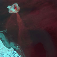 Augustine Volcano, Alaska, USA Sensor: L7 ETM+ Path/Row: 70/19 Lat/Long: 59.363/-153.431 Category: Natural Disasters Download High Resolution |  Wildfires in Alberta, Canada Sensor: L7 ETM+ Path/Row: 42/19, 20 Lat/Long: 58.700/-110.200 Category: Natural Disasters Download High Resolution Date Posted: 06/20/2011 |  Western Russia Sensor: L7 ETM+, L 5 TM Path/Row: 173/21 Lat/Long: 55.900/45.800 Category: Natural Disasters Download High Resolution Date Posted: 10/18/2010 |  The Selenge River Delta Sensor: L5 TM Path/Row: 132/24 Lat/Long: 51.700/107.000 Category: Natural Disasters Download High Resolution Date Posted: 07/05/2011 |
 Mount St. Helens Sensor: L1 MSS, L2 MSS, L5 TM Path/Row: 46/28 Lat/Long: 46.000/-122.400 Category: Natural Disasters Download High Resolution Date Posted: 08/06/2012 |  The Lakes of Eastern Day County, South Dakota Sensor: L5 TM Path/Row: 30/28 Lat/Long: 46.000/-97.700 Category: Natural Disasters Download High Resolution Date Posted: 09/20/2012 |  Mustang Complex Fire Sensor: L7 ETM+ Path/Row: 41/28 Lat/Long: 46.000/-114.700 Category: Natural Disasters Download High Resolution Date Posted: 10/16/2012 | 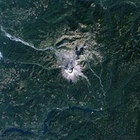 Mount St. Helens, Washington, USA Sensor: L5 TM Path/Row: 46/28 Lat/Long: 46.199/-122.188 Category: Natural Disasters Download High Resolution |
 Northern Wisconsin Tornados, USA Sensor: L7 ETM+ Path/Row: 24/29 Lat/Long: 45.083/-88.844 Category: Natural Disasters Download High Resolution |  Ricco Fire, Black Hills, SD, USA Sensor: L7 ETM+ Path/Row: 33/29 Lat/Long: 44.217/-103.387 Category: Natural Disasters Download High Resolution |  Yellowstone National Park Sensor: L5 TM Path/Row: 38/29 Lat/Long: 44.459/-110.833 Category: Natural Disasters Download High Resolution Date Posted: 5/15/2008 |  Karmadon Gorge Avalanche, Russia Sensor: L7 ETM+ Path/Row: 170/30 Lat/Long: 42.858/44.522 Category: Natural Disasters Download High Resolution |
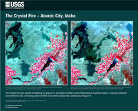 Crystal Fire, Atomic City, Idaho, USA Sensor: L7 ETM+ Path/Row: 39/30 Lat/Long: 42.998/-112.636 Category: Natural Disasters Download High Resolution |  Black Hills, South Dakota, USA Sensor: L7 ETM+ Path/Row: 33/30 Lat/Long: 43.957/-103.328 Category: Natural Disasters Download High Resolution |  Long Butte, Idaho fire Sensor: L5 TM Path/Row: 41/30 Lat/Long: 43.200/-115.700 Category: Natural Disasters Download High Resolution Date Posted: 10/07/2010 | 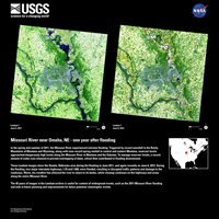 Missouri River near Omaha, NE - one year after flooding Sensor: L7 ETM+ Path/Row: 28/31 Lat/Long: 41.800/-96.100 Category: Natural Disasters Download High Resolution Date Posted: 07/02/2012 |
 Western Fires Sensor: L7 ETM+ Path/Row: 42/31 Lat/Long: 41.800/-117.700 Category: Natural Disasters Download High Resolution Date Posted: 08/24/2012 |  Rural New York Flooding from Hurricane Irene Sensor: L5 TM Path/Row: 14/31 Lat/Long: 41.800/-74.400 Category: Natural Disasters Download High Resolution Date Posted: 09/01/2011 |  High Park Fire, Colorado - June 2012 Sensor: L5 TM, L7 ETM+ Path/Row: 34/32 Lat/Long: 40.300/-105.800 Category: Natural Disasters Download High Resolution Date Posted: 06/21/2012 |  Picnic Rock Fire, Colorado, USA Sensor: L5 TM Path/Row: 34/32 Lat/Long: 40.727/-105.215 Category: Natural Disasters Download High Resolution |
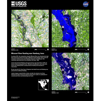 Missouri River flooding near Hamburg, Iowa Sensor: L5 TM, L7 ETM+, L5 TM Path/Row: 27/32 Lat/Long: 40.300/-95.000 Category: Natural Disasters Download High Resolution Date Posted: 09/20/2011 | 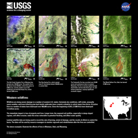 Western Wildfires Sensor: L7 ETM+ Path/Row: 38/33 Lat/Long: 38.900/-112.400 Category: Natural Disasters Download High Resolution Date Posted: 07/13/2012 |  Hayman Springs Fires, Colorado, USA Sensor: L7 ETM+ Path/Row: 33/33 Lat/Long: 39.185/-105.021 Category: Natural Disasters Download High Resolution | 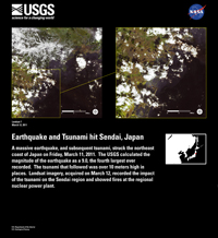 Earthquake and Tsunami hit Sendai, Japan Sensor: L7 ETM+ Path/Row: 107/33 Lat/Long: 38.900/141.000 Category: Natural Disasters Download High Resolution Date Posted: 03/18/2011 |
 Joplin, Missouri � One Year Later Sensor: L7 ETM+ Path/Row: 26/34 Lat/Long: 37.500/-94.300 Category: Natural Disasters Download High Resolution Date Posted: 05/16/2012 |  Southern Nevada Wildfires, USA Sensor: L7 ETM+ Path/Row: 39/34 Lat/Long: 37.182/-114.639 Category: Natural Disasters Download High Resolution |  Greece Fires - 2007 Sensor: L7 ETM+ Path/Row: 183/34 Lat/Long: 37.074/22.424 Category: Natural Disasters Download High Resolution |  Indiana Flooding Sensor: L5 TM Path/Row: 22/32-34 Lat/Long: 38.9/-87.7 Category: Natural Disasters Download High Resolution Date Posted: 5/20/2008 |
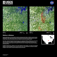 Wildfires in Oklahoma Sensor: L7 ETM+ Path/Row: 27/35 Lat/Long: 36.000/-96.300 Category: Natural Disasters Download High Resolution Date Posted: 08/07/2012 |  Creek County, Oklahoma fire Sensor: L7 ETM+ Path/Row: 27/35 Lat/Long: 36.000/-96.300 Category: Natural Disasters Download High Resolution Date Posted: 09/28/2012 |  Tennessee Flooding Sensor: L5 TM Path/Row: 23/35 Lat/Long: 36.000/-90.100 Category: Natural Disasters Download High Resolution Date Posted: 06/03/2010 |  Arizona Fire Sensor: L5 TM Path/Row: 37/35 Lat/Long: 36.000/-111.700 Category: Natural Disasters Download High Resolution Date Posted: 07/09/2010 |
 Flooding Along the Mississippi Sensor: L5 TM Path/Row: 23/35 Lat/Long: 36.000/-90.100 Category: Natural Disasters Download High Resolution Date Posted: 05/11/2011 |  Las Conchas, New Mexico, fires Sensor: L5 TM, L7 ETM+ Path/Row: 34/35 Lat/Long: 36.000/-107.100 Category: Natural Disasters Download High Resolution Date Posted: 07/14/2011 | 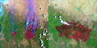 Rodeo Chediski Fires, Arizona, USA Sensor: L7 ETM+ Path/Row: 36/36 Lat/Long: 34.095/-110.323 Category: Natural Disasters Download High Resolution |  Sawtooth and Millard Fires, CA, USA Sensor: L7 ETM+ Path/Row: 40/36 Lat/Long: 34.054/-116.637 Category: Natural Disasters Download High Resolution |
 Station Fire California - 2009 Sensor: L7 ETM+ Path/Row: 41/36 Lat/Long: 34.600/-118.300 Category: Natural Disasters Download High Resolution Date Posted: 09/01/2009 | 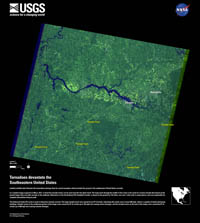 Tornadoes devastate the Southeastern United States Sensor: L7 ETM+ Path/Row: 21/36 Lat/Long: 34.600/-87.400 Category: Natural Disasters Download High Resolution Date Posted: 05/09/2011 |  Mississippi River Flooding Sensor: L5 TM Path/Row: 23/36 Lat/Long: 34.600/-90.500 Category: Natural Disasters Download High Resolution Date Posted: 05/12/2011 |  Tornadoes devastate the Southeastern United States Sensor: L7 ETM+ Path/Row: 21/36 and 37 Lat/Long: 34.600/-87.400 Category: Natural Disasters Download High Resolution Date Posted: 05/13/2011 |
 Wallow Fire, Arizona Sensor: L7 Path/Row: 35/36 and 37 Lat/Long: 33.820/-109.330 Category: Natural Disasters Download High Resolution Date Posted: 06/08/2011 |  Juniper Road Fire Sensor: L5 TM Path/Row: 15/36 Lat/Long: 34.600/-78.200 Category: Natural Disasters Download High Resolution Date Posted: 08/25/2011 |  Whitewater Baldy Complex Fire, New Mexico Sensor: L7 ETM+ Path/Row: 35/37 Lat/Long: 32.200/-109.500 Category: Natural Disasters Download High Resolution Date Posted: 06/13/2012 |  Southern California Wildfires, USA - 2003 Sensor: L7 ETM+ Path/Row: 40/37 Lat/Long: 33.490/-116.033 Category: Natural Disasters Download High Resolution |
 Southern California Wildfires, USA - 2006 Sensor: L5 TM Path/Row: 40/37 Lat/Long: 33.837/-117.665 Category: Natural Disasters Download High Resolution |  Esperanza Fire, California, USA Sensor: L5 TM Path/Row: 40/37 Lat/Long: 33.837/-116.836 Category: Natural Disasters Download High Resolution |  Sakura-jima Volcano, Japan Sensor: L7 ETM+ Path/Row: 112/38 Lat/Long: 31.589/130.658 Category: Natural Disasters Download High Resolution |  Texas Wildfires, USA Sensor: L7 ETM+ Path/Row: 29/38 Lat/Long: 31.368/-100.537 Category: Natural Disasters Download High Resolution |
 Georgia Fires, USA Sensor: L5 TM Path/Row: 17/38 Lat/Long: 31.121/-82.423 Category: Natural Disasters Download High Resolution | 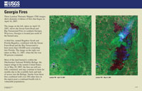 Georgia Fires, USA Sensor: L5 TM Path/Row: 17/38 Lat/Long: 31.150/-82.441 Category: Natural Disasters Download High Resolution |  Honey Prairie Fires Sensor: L5 TM Path/Row: 17/38,39 Lat/Long: 30.900/-82.200 Category: Natural Disasters Download High Resolution Date Posted: 07/15/2011 |  Hurricane Isaac Flooding Sensor: L7 ETM+ Path/Row: 22/39 Lat/Long: 30.300/-90.100 Category: Natural Disasters Download High Resolution Date Posted: 09/06/2012 |
 New Orleans, LA, USA after Hurricane Katrina Sensor: L7 ETM+ Path/Row: 22/39 Lat/Long: 30.010/-90.095 Category: Natural Disasters Download High Resolution |  Hurricane Katrina � Before and After in New Orleans Sensor: L7 ETM+ Path/Row: 22/39 Lat/Long: 30.307/-90.148 Category: Natural Disasters Download High Resolution |  Biloxi, Mississippi � Hurricane Katrina Aftermath Sensor: L5 TM, L7 ETM+ Path/Row: 21/39 Lat/Long: 30.392/-88.932 Category: Natural Disasters Download High Resolution |  Mississippi Coastline - Hurricane Katrina Aftermath Sensor: L7 ETM+ Path/Row: 21/39 Lat/Long: 30.342/-88.586 Category: Natural Disasters Download High Resolution |
 April Fires in Western Texas Sensor: L5 TM Path/Row: 31/39 Lat/Long: 30.300/-104.100 Category: Natural Disasters Download High Resolution Date Posted: 04/21/2011 |  Lee Soaks Gulf Coast area Sensor: L7 ETM+, L5 TM Path/Row: 24/39 Lat/Long: 30.300/-93.200 Category: Natural Disasters Download High Resolution Date Posted: 09/09/2011 |  Bastrop County Complex Fire Sensor: L5 TM Path/Row: 27/39 Lat/Long: 30.300/-97.900 Category: Natural Disasters Download High Resolution Date Posted: 09/11/2011 |  Fires Burn Northern Mexico Sensor: L5 TM Path/Row: 30/40 Lat/Long: 28.900/-102.900 Category: Natural Disasters Download High Resolution Date Posted: 05/06/2011 |
 Rio Grande Flooding Sensor: L5 TM Path/Row: 28/41 Lat/Long: 27.400/-100.200 Category: Natural Disasters Download High Resolution Date Posted: 10/18/2010 |  La Cordillera Regrowth Sensor: L7 ETM+, L5 TM Path/Row: 8/47 Lat/Long: 18.800/-71.300 Category: Natural Disasters Download High Resolution Date Posted: 01/12/2012 |  Cyclone Nargis Hits Burma Sensor: L7 ETM+ Path/Row: 132/48 & 49 Lat/Long: 16.55/96.55 Category: Natural Disasters Download High Resolution Date Posted: 08/21/2008 |  Tsunami and Devi Point, India Sensor: L7 ETM+ Path/Row: 142/49 Lat/Long: 15.977/81.141 Category: Natural Disasters Download High Resolution |
 Banda Aceh � Tsunami Before and After Sensor: L7 ETM+ Path/Row: 131/56 Lat/Long: 5.605/95.348 Category: Natural Disasters Download High Resolution |  Savanna fires Sensor: L7 ETM+ Path/Row: 223/67 Lat/Long: -10.100/-49.800 Category: Natural Disasters Download High Resolution Date Posted: 01/28/2013 |  Gulf of Carpentaria, Australia Sensor: L5 TM Path/Row: 99/72 Lat/Long: -17.300/140.200 Category: Natural Disasters Download High Resolution Date Posted: 02/08/2011 |  Fires Scorch Northern Australia Sensor: L5 TM Path/Row: 104/72 Lat/Long: -17.300/132.500 Category: Natural Disasters Download High Resolution Date Posted: 10/06/2011 |
 Central Queensland Flooding, Australia Sensor: L5 TM Path/Row: 96/78 Lat/Long: -26.000/142.800 Category: Natural Disasters Download High Resolution Date Posted: 02/08/2011 |  Flooding in Southern Australia Sensor: L7 ETM+ Path/Row: 92/81 Lat/Long: -30.300/147.900 Category: Natural Disasters Download High Resolution Date Posted: 01/24/2011 | 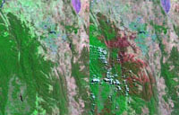 Fires Near Canberra, Australia Sensor: L7 ETM+ Path/Row: 90/84 Lat/Long: -35.397/148.873 Category: Natural Disasters Download High Resolution |  Regrowth in Australia after Massive Bushfires Sensor: L5 TM Path/Row: 92/86 Lat/Long: -37.500/145.900 Category: Natural Disasters Download High Resolution Date Posted: 05/26/2011 |
 Puyehue Volcano Sensor: L5 TM Path/Row: 233/88 Lat/Long: -40.300/-72.800 Category: Natural Disasters Download High Resolution Date Posted: 07/06/2011 |  Brush Fires in Tasmania Sensor: L7 ETM+ Path/Row: 90/90 Lat/Long: -43.200/147.200 Category: Natural Disasters Download High Resolution Date Posted: 01/16/2013 |  Sawtooth and Millard Fires, CA, USA at night Sensor: L7 ETM+ Path/Row: 138/208 Lat/Long: 34.054/-116.640 Category: Natural Disasters Download High Resolution |