Alaska Pacific Ocean Radiofacsimile Schedule
Products listed on this page are provided by the Ocean Prediction Center and the
National Weather Service Forecast Office in Anchorage, Alaska. The forecast area includes the North Pacific
Alaska offshore and high seas waters. The products listed on this page are transmitted via high frequency
(HF) through transmitters of the United States Coast Guard from Kodiak, Alaska. The shortwave HF signal
is decoded by Weather FAX receivers onboard ships in the forecast area. The broadcast frequencies are listed below.
NOTE: If you are interested in printing the marine weather charts listed on this page a
TIFF viewer is required to have a white
background. Also, the black & white GIF images are available for printing, but they are not ideally sized for printing the
complete chart. The GIF marine weather charts are colored and have a black background.
Time delay of analysis products: Graphic analysis/forecast charts broadcast by radiofacsimile are available by
broadcast time and are usually available 30 minutes prior to broadcast.
Click for information on key terms & symbols used on charts and for information on the
coding used on the surface preliminary analysis.
NOAA National Weather Service Washington, D.C.
Your browser isn't running a script for displaying the current greenwich mean time which displays on the web page and on the toolbar.
Standard Time
Atlantic Time Eastern Time Central Time Mountain Time Pacific Time Alaska Time Hawaii Time
Z difference
-4 -5 -6 -7 -8 -9 -10
problems or comments?
NOTE: The terms Coordinated
Universal Time (UTC) and Zulu (Z) are equivalent.
Print Latest Schedule valid as of June 15, 2005Latest Radiofacsimile Schedule Change effective June
15, 2005. Worldwide Radiofacsimile Broadcast Schedule PDF
Note: The FTPmail
or WMO ID can be used to send e-mail of text messages/charts
created by
the Ocean Prediction Center.
0400Z
Test Pattern
PZZZ93
0403Z
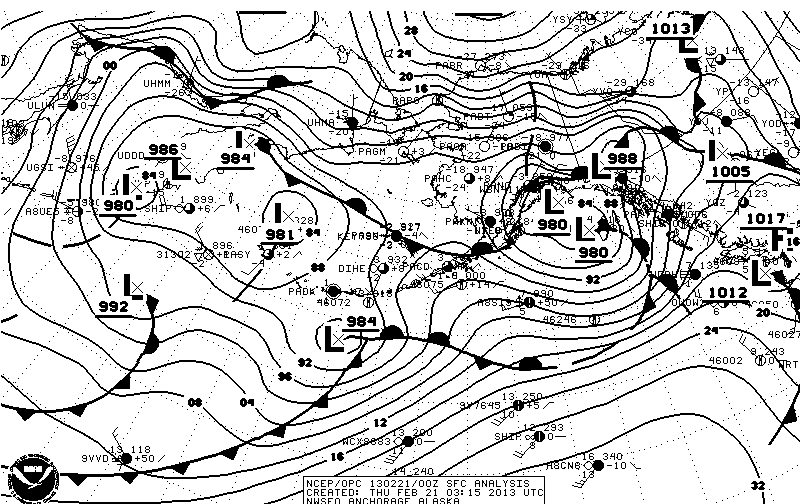
00Z Surface Analysis (40N-70N, 125W-150E)
PYCA00
TIF|GIF|B/W GIF
0427Z
Rebroadcast 24Hr Surface VT 12Z (40N-70N, 115W-170E)
PYBE01
TIF |GIF |B/W GIF 18:08Z, 15 February 2013
0437Z
Rebroadcast 48Hr Surface VT 12Z (20N-70N, 115W-135E)
PWBI99
TIF |GIF |B/W GIF 17:46Z, 15 February 2013
0447Z
Coastal Marine Forecast Tables (Alaska)
0456Z
00Z Sea State Analysis (20N-70N, 115W-135E)
PJBA99
TIF |GIF |B/W GIF 01:39Z, 16 February 2013
0506Z
Satellite Picture (05N-60N, 110W-160W)
0517Z
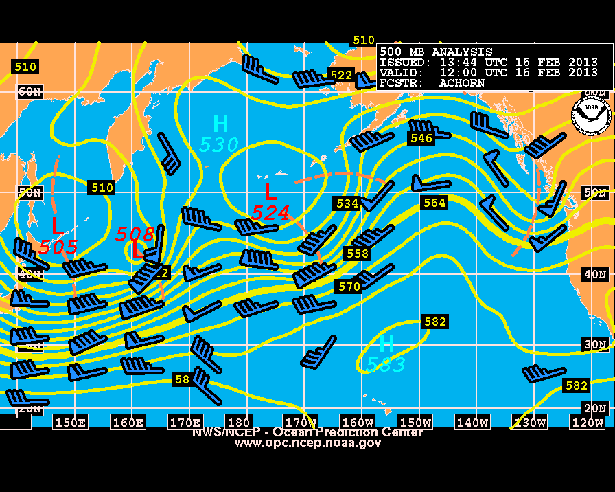
00Z 500mb Analysis (20N-70N, 115W-135E)
PPBA50
TIF |GIF |B/W GIF 00:54Z, 16 February 2013
0527Z
Symbols and Contractions/Schedule
0548Z
Request For Comments/Product Notice
0558Z
24Hr 500mb VT 00Z (20N-70N, 115W-135E)
PPBE50
TIF |GIF |B/W GIF 04:45Z, 15 February 2013
0950Z
Test Pattern
0953Z
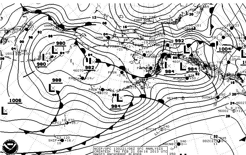
06Z Surface Analysis (40N-70N, 125W-150E)
PYCA01
TIF|GIF |B/W GIF
1017Z
24Hr Wind&Wave VT 00Z (40N-70N, 115W-170E)
PJBE88
TIF |GIF |B/W GIF 06:27Z, 15 February 2013
1027Z
24Hr Surface VT 00Z (40N-70N, 115W-170E)
PYBE00
TIF |GIF |B/W GIF 05:49Z, 15 February 2013
1037Z
48Hr Surface VT 00Z (20N-70N, 115W-135E)
PWBI98
TIF |GIF |B/W GIF 06:25Z, 15 February 2013
1047Z
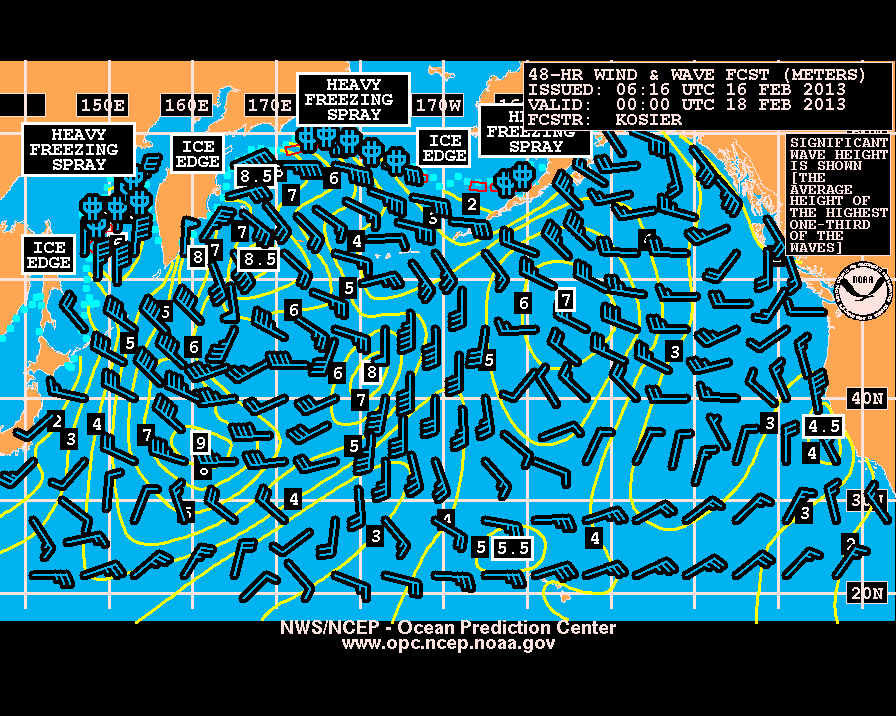
48Hr Wind&Wave VT 00Z (20N-70N, 115W-135E)
PJBI98
TIF |GIF |B/W GIF
1057Z
5-Day Sea Ice Forecast/Sea Ice Analysis
1117Z
Satellite Picture (05N-60N, 110W-160W)
1128Z
48Hr Peak Wave Period&Direction/Ice Accretion VT 00Z (20N-70N, 115W-135E)
PJBI88
TIF |GIF |B/W GIF 04:20Z, 15 February 2013
1138Z
48Hr 500mb VT 00Z (20N-70N, 115W-135E)
PPBI50
TIF |GIF |B/W GIF 04:39Z, 15 February 2013
1148Z
Sea Surface Temperature Analysis (40N-60N, 125W-160E)
1159Z
Cook Inlet Sea Ice Forecast (Cook Inlet)
1600Z
Test Pattern
1603Z
12Z Surface Analysis (40N-70N, 125W-150E)
PYCA02
TIF|GIF|B/W GIF
1627Z
Rebroadcast 24Hr Surface VT 00Z (40N-70N, 115W-170E)
PYBE00
TIF |GIF |B/W GIF 05:49Z, 15 February 2013
1637Z
Rebroadcast 48Hr Surface VT 00Z (20N-70N, 115W-135E)
PWBI98
TIF |GIF |B/W GIF 06:25Z, 15 February 2013
1647Z
Coastal Marine Forecast Tables (Alaska)
1656Z
Rebroadcast 00Z Sea State Analysis (20N-70N, 115W-135E)
PJBA99
TIF |GIF |B/W GIF 01:39Z, 16 February 2013
1706Z
Satellite Picture (05N-60N, 110W-160W)
1717Z
12Z 500mb Analysis (20N-70N, 115W-135E)
PBBA51
TIF |GIF |B/W GIF 12:16Z, 15 February 2013
1727Z
Symbols and Contractions/Schedule
1748Z
Request For Comments/Product Notice
1758Z
24Hr 500mb VT 12Z (20N-70N, 115W-135E)
PPBE51
TIF |GIF |B/W GIF 16:02Z, 15 February 2013
2150Z
Test Pattern
2153Z
18Z Surface Analysis (40N-70N, 125W-150E)
PYCA03
TIF|GIF|B/W GIF
2217Z
24Hr Wind&Wave VT 12Z (40N-70N, 115W-170E)
PJBE89
TIF |GIF |B/W GIF 19:37Z, 15 February 2013
2227Z
24Hr Surface VT 12Z (40N-70N, 115W-170E)
PYBE01
TIF |GIF |B/W GIF 18:08Z, 15 February 2013
2237Z
48Hr Surface VT 12Z (20N-70N, 115W-135E)
PWBI99
TIF |GIF |B/W GIF 17:46Z, 15 February 2013
2247Z
48Hr Wind&Wave VT 12Z (20N-70N, 115W-135E)
PJBI99
TIF |GIF |B/W GIF 17:33Z, 15 February 2013
2257Z
5-Day Sea Ice Forecast/Sea Ice Analysis
2317Z
Satellite Picture (05N-60N, 110W-160W)
2328Z
48Hr Peak Wave Period&Direction/Ice Accretion VT 00Z (20N-70N, 115W-135E)
PJBI89
TIF |GIF |B/W GIF 16:21Z, 15 February 2013
2338Z
48Hr 500mb VT 12Z (20N-70N, 115W-135E)
PPBI51
TIF |GIF |B/W GIF 15:56Z, 15 February 2013
2348Z
96Hr Surface Forecast VT 12Z (20N-70N, 115W-135E)
PWBM99
TIF |GIF |B/W GIF 18:42Z, 15 February 2013
2358Z
96Hr Wind&Wave VT 12Z (20N-70N, 115W-135E)
PJBM98
TIF |GIF |B/W GIF 19:36Z, 15 February 2013
0008Z
96Hr Peak Wave Period&Direction/Ice Accretion VT 12Z (20N-70N, 115W-135E)
PJBM88
TIF |GIF |B/W GIF 16:21Z, 15 February 2013
0018Z
96Hr 500mb Forecast VT 12Z (20N-70N, 115W-135E)
PPBM50
TIF |GIF |B/W GIF 14:53Z, 15 February 2013
Contractions: VT=VALID TIME, WV=Wave, Bul=Bulletin, Hr=Hour, Prelim=Preliminary
Assigned Frequencies(KHZ): Day = 2054, 4298, 8459, 12412.5 kHz
Many of these charts are also broadcast from Point Reyes, CA.


