
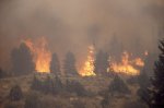
| Fire and Smoke | Operational Products Automated Biomass Burning Algorithm (ABBA) - from CIMSS Fire Id, Mapping and Monitoring Algorithm (FIMMA) Fire Product Archive GOES Aerosol Smoke Products (GASP): Hazard Mapping System (HMS) Fire and Smoke Analysis Developmental Products Fire Risk Smoke Text Product Web Based GIS Fire Analysis Satellite Imagery Fire/Smoke/Hot Spot Imagery Fire/Hot Spot Sectors: Florida | Northern California | Southern California GOES-East Sectors: Regional | WFO Sectors GOES-West Sectors: Regional | WFO Sectors Operational Significant Event Imagery - Fire Events (Archive) |
|
| Precipitation | Operational Products Ensemble Tropical Rainfall Potential (eTRaP) Microwave Rain Rate: MSPPS | SSM/I | SSM/IS Precipitable Water Index Rainfall Hydro Estimator Satellite Precipitation Estimate Messages (SPENES) Total Precipitable Water ATOVS | MSPPS | SSM/I | |
|
|
||
| Snow and Ice | Operational Products Snow Cover - MSPPS Snow Depth - SSM/I (Mapped) Snow and Ice Cover Analysis (IMS) - Daily NH 4-km | Daily SH 4-km Snow Water Equivalent Developmental Products Automated Snow Mapping System |
|
|
|
||
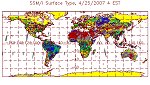
| Surface & Hydrology | Operational Products Land Surface Emissivity (MSPPS) Soil Moisture (SSM/I) Surface & Insolation Products (GSIP-fd) Surface Temperature (DPI ) (Image | Loop) Surface Temperature MSPPS | SSM/I Surface Type (SSM/I) | |
|
|
||


