Provides access to a comprehensive list of GIS resources of Mississippi
Contains ocean observations from a comprehensive network of observing systems and data servers
Lists many other national, state, regional, and local data resources
Displaying 8 Results
National Oceanic and Atmospheric Administration
Orthoimagery to support national security and emergency response requirements
National Oceanic and Atmospheric Administration and partners
Imagery data sets with variable specifications and geographic extents, acquired to support projects with state and local partners
National Oceanic and Atmospheric Administration
Aerial photography collected to support the regular updating and delineation of the nation's shoreline
U.S. Army Corps of Engineers
Seafloor reflectance collected by the Compact Hydrographic Airborne Rapid Total Survey (CHARTS) system
U.S. Army Corps of Engineers
Mosaics created from individual images collected by the Compact Hydrographic Airborne Rapid Total Survey (CHARTS) system
National Aeronautics and Space Administration, U.S. Geological Survey
Continuous time series of consistent satellite image spectral data
National Oceanic and Atmospheric Administration
Information on seafloor composition, texture, and physical characteristics throughout U.S. waters
National Oceanic and Atmospheric Administration
Information on the composition, structure, and layering of soft sediments below the seafloor

 Emergency Response Imagery
 High-Resolution Orthoimagery
 Historical Aerial Photography
  JALBTCX Bottom Reflectance
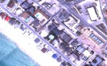 JALBTCX Orthomosaics
 Landsat Satellite Imagery
 Side-Scan Sonar Backscatter
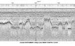 Sub-Bottom Profile