NASA header National Aeronautics and Space Administration Global Climate Change: Vital Signs of the Planet National Aeronautics and Space Administration
Blog banner
Dr. Amber Jenkins

Amber Jenkins is Editor of NASA's Climate Change website and project manager of the Center for Climate Sciences at NASA's Jet Propulsion Laboratory. She's passionate about climate change, science and science communication.

More ›

Climate change chronicles from NASA


Dare to dream ...
The X factor
September 29, 2010
posted by Dr. Amber Jenkins
17:00 PDT
Dare to dream ...
On June 20, 2008, the Jason-2 satellite was launched aboard a Delta II rocket from Space Launch Complex 2 at Vandenberg Air Force Base, Calif. Jason-2 has been very successfully tracking sea level rise from space. Photo credit: United Launch Alliance.

Tony Freeman

By Dr. Tony Freeman, NASA Jet Propulsion Laboratory

How does a new space mission get off the ground? I was thinking about this the other day, watching our Team X* design a mission to look at greenhouse gases in Earth’s atmosphere from orbit.

This particular mission had its genesis in an idea from a couple of scientists who suggested that looking at greenhouse gases in the tropics — where there are few ground stations that can measure carbon dioxide or methane, for example — would really add to the state of our knowledge of the mechanisms that produce these gases.

Starting from this simple idea, the scientists then talk to engineers who can help make their dream a practical proposition. The first question is: Can we design an instrument to measure greenhouse gases in the atmosphere with the right accuracy to make a difference? (Yes.) And the second question is: Can we fly the instrument on a satellite in an orbit that looks just at the tropics? (Also yes.)

This conversation between engineers and scientists continues for some time — the scientists push to exploit the measurements the engineers can make, sometimes the engineers push back and say, “We can’t do that, but we can do this.” At other times the engineers ask: “If we could make this measurement, would that be useful?”

How long does this process take? From the original idea to the launch of a space mission that realizes the concept can take as little as 10 years, or as long as 25. That may seem like a long time, but along the way you have to persuade a whole segment of the science community that this mission is exactly the thing they have been missing, and then identify anywhere between $300M and upwards of $1B of (usually government) funding to execute the mission. Not a decision to take lightly.

The rewards though are great — to see an idea that was just a gleam in someone’s eye standing on the launch pad, representing the hopes and dreams of a portion of the science community, while the mission controller starts the countdown, is an incredible experience.

*Team X is an Advanced Projects Design Team made up of roughly 25 engineers and scientists who work together to design space missions at JPL.

Tony is an Earth Science manager at JPL in Pasadena, Calif.

comments ( )

Sentinels of climate change
Chip off the old (ice) block
September 29, 2010
posted by Dr. Amber Jenkins
17:00 PDT
Sentinels of climate change

Pictures say a thousand words, right? Sometimes images say more about climate change than any story can. So In that vein, we've just launched a new interactive "Global Ice Viewer" that lets you explore what's been happening to Earth's ice cover lately.

We feature stunning time-lapse movies and dramatic before and after images of glaciers, sea ice and continental ice sheets around the globe. Take a look for yourself here.

comments ( )

Frigid beauty
Where art meets science
September 29, 2010
posted by Dr. Amber Jenkins
17:00 PDT

Here's an interesting video I stumbled across from UCLA professor Rebeca Méndez. She shot these images with a Bolex 16mm film camera in Iceland and Los Angeles between 2006 and 2009. Méndez is heading to the Arctic Circle soon along with a group of artists, scientists, architects and educators on board an ice-class sailing vessel to photograph and video the ice there.

comments ( )

Bolt from the blue
Lightning never strikes twice, but ...
September 27, 2010
posted by Dr. Amber Jenkins
17:00 PDT
Bolt from the blue
Image courtesy of Earth Science Picture of the Day. Photo by Robert Arn.

From Gretchen Cook-Anderson, NASA Earth Science News Team

Though the old adage that lightning never strikes twice generally rings true, apparently lightning can strike in very short order in more than a dozen points alongside one another as it did near Keota, Colorado on August 6, 2010. Photographer Robert Arn captured this bedazzling time-lapsed display of lightning over less than 30 seconds across Pawnee National Grasslands while awaiting darkness to fall at a stargazing party.

Speaking of flashes of brilliance, far from the prairies and big skies of the Plains, NASA's Lightning Instrument Package, or LIP, flew aboard an unmanned, storm-chasing Global Hawk aircraft earlier this month over the Gulf of Mexico and the Atlantic Ocean detecting and documenting lightning during intensifying hurricanes. LIP and 14 other instruments were part of the Genesis and Rapid Intensification Process mission, commonly called GRIP, which drew to a close this week. Scientists expect the GRIP field experiments will eventually yield the most comprehensive data about hurricanes to date once scientists analyze 40 flight days' worth of new information.

NASA's Earth Science Picture of the Day website featured the white lightning strikes above on September 7, 2010. To see more images recorded by amateur and professional photographers and to learn more about Earth Science Picture of the Day, click here.

Cross-posted from What on Earth. Gretchen is based in Chicago.

comments ( )

September 27, 2010
posted by Dr. Amber Jenkins
17:00 PDT

How do we know which storms will intensify into monsters and which ones will fizzle out rapidly? NASA takes an unprecedented look into the mechanics of storms.

comments ( )

A clearer picture
AIRS data a valuable asset
September 27, 2010
posted by Dr. Amber Jenkins
17:00 PDT

AIRS, the Atmospheric Infrared Sounder onboard NASA's Aqua Satellite, is helping produce a clearer picture of how Earth's weather and climate has evolved over time. Information about our atmosphere collected by AIRS, and by other satellite systems, has been used to build a new, high-quality climate data record that has just been released by the National Centers for Environmental Protection (NCEP) and the National Center for Atmospheric Research (NCAR). The data span from 1979 to the present and are of higher precision.

Duane Waliser, Chief Scientist of the Earth Science and Technology Directorate at NASA's Jet Propulsion Laboratory commented on the news: "It is a credit to the AIRS mission to create products that contribute to weather forecast quality and to resources heavily used for climate analysis and climate model validation."

For more information, visit the AIRS website.

comments ( )

Pick of the pics
Mother Ganges
September 27, 2010
posted by Dr. Amber Jenkins
17:00 PDT
Pick of the pics
Caption: Credit: NASA/GSFC/METI/ERSDAC/JAROS and the U.S./Japan ASTER Science Team.

Today’s pick of the pics shows the western-most part of the Ganges Delta, as seen by NASA’s ASTER (Advanced Spaceborne Thermal Emission and Reflection Radiometer) instrument on 6 January, 2005. The Hugli River branches off from the Ganges River 300 kilometers (186 miles) to the north, and flows past the city of Calcutta before emptying into the Bay of Bengal. The light tan colors in the water reveal high levels of sediment load, particularly downstream from offshore islands. The deep green colors of some of these islands are mangrove swamps. The size of the image is 55 by 60 kilometers (34 by 37 miles).

Caption and image courtesy of ASTER’s image gallery.

comments ( )

Quote of the week
The canary in the coal mine
September 23, 2010
posted by Dr. Amber Jenkins
17:00 PDT

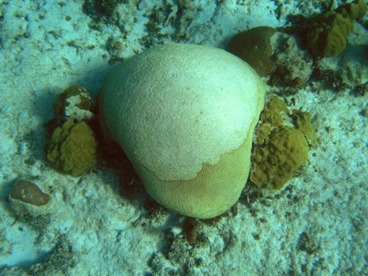
Bleached brain coral. Photo credit: Liane Guild, NASA Ames Research Center. Bleached brain coral. Photo credit: Liane Guild, NASA Ames Research Center.


" “I am significantly depressed by the whole situation.”

Clive Wilkinson, director of the Global Coral Reef Monitoring Network "


What’s Wilkinson talking about? His quote comes from a story in the New York Times earlier this week, reporting that coral reefs are in serious trouble. This year we’re witnessing the second known worldwide bleaching of coral reefs.

Bleaching happens when reefs go into survival mode. The corals cast out the tiny algae that help them thrive and give them their color. Why? Because they’re extremely sensitive to temperature changes, and the oceans are heating up as a result of global warming.

A study published in Nature earlier this year by an international team including NASA oceanographer Josh Willis found that between 1993 and 2008, the upper 700 meters of the oceans absorbed 0.64 Watts per square meter (calculated for the Earth’s entire surface area). Lead author John Lyman, an oceanographer at the University of Hawaii's Joint Institute for Marine and Atmospheric Research, put this into layperson-speak: this is roughly equivalent to the power of two billion copies of the atomic bomb the United States dropped on Hiroshima, Japan, during World War II.

Simply put, the global warming of the oceans is stressing out the reefs. And those that care about them. Coral reefs not only make up one of the richest ecosystems in our oceans, but they are home to a great many fish species and are the backbone of fisheries that feed millions of people.

As NASA oceanographer Gene Carl Feldman has said: “Like the canary in the coal mine, coral can provide an early warning of potentially dangerous things to come."

comments ( )

Eyeing the eye
Risky business?
September 20, 2010
posted by Dr. Amber Jenkins
17:00 PDT
Eyeing the eye

From Patrick Lynch, NASA Langley Research Center

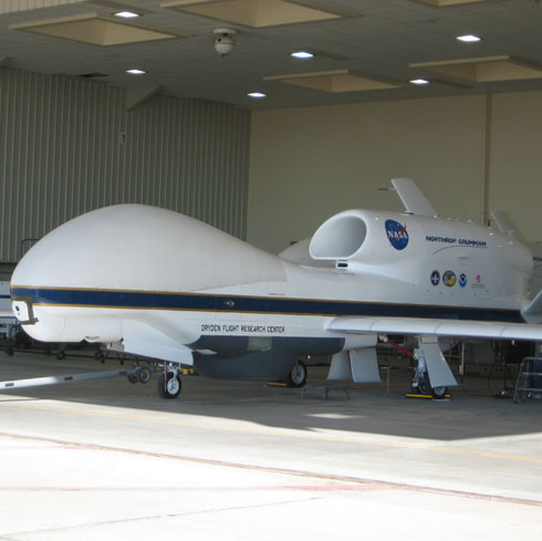
You can learn a lot about a hurricane by flying through it. So NASA does just that — using both unmanned aircraft (the Global Hawk) and manned ones, with pilots in the cockpit the old-fashioned way (the DC-8 and WB-57). But just what is it like to fly through a hurricane?

Dryden Flight Research Center DC-8 pilot Dick Ewers flew through Hurricane Earl recently as part of NASA’s hurricane research campaign known as GRIP (Genesis and Rapid Intensification Processes). He gave the media some insights as he prepared for his final journey through Earl.
1. What’s it like flying through a hurricane?

It’s pretty bumpy at times, but most of the time it’s a lot of clouds. Then, as we get closer, we’ll go into some bumps and turbulence. As we break out into the eye, hopefully we’ll be able to see the sky above and all the way down to the water below. That’s very nice. All of a sudden you’re out of the car wash and you’re looking down and can see what’s happening below. Normally it’s about 10 to 15 minutes of excitement per hour.

2. How strong did Hurricane Earl get when you flew through it?

At our [altitude] it was about 100 mph, but the worst part is down below. We’re above [the area] where it’s very intense. And when you’re flying in an airplane and through an airmass, and the airmass is moving at 100 mph, you don’t really notice that. But what you do notice is when you come out, the winds drops off and the aircraft rises and falls based on what’s happening around it. So the plane isn’t able to be very level at times.

3. How risky is it?

My job is to take the risk out of it. My job is to make sure what I do is safe and doesn’t put the scientists or the instruments at risk. My whole mission is to make sure that plane is back here tonight. Where the risk and danger is, I will take precautions and go around it and do something to avoid something where danger is involved.

4. How many flights did you make through Earl?

This will be the fourth and final flight. We thought it was declining yesterday, but it's stronger this morning, so we're going back out.

5. How was the view of the eye?

Rarely are storms very crystal clear. This one had a lot of strataform in there, so there were clouds around and above us, and it wasn’t a pristine, clear blue eye. But you were able to see daylight above us and the water below us. I want to say [the eye] was 20 to 25 miles [32 to 40 kilometers] wide inside. You wouldn’t want to be in a boat down there.

Adapted and cross-posted from NASA’s What on Earth blog. Patrick is based near Washington, D.C.

comments ( )

Burn baby, burn
Six ways to burn a hole in the ozone layer
September 17, 2010
posted by Dr. Amber Jenkins
17:00 PDT
Burn baby, burn
The ozone hole over the South Pole as of 14 September, 2010. Credit: Ozone Hole Watch.

This year's annual depletion of stratospheric ozone over Antarctica – more commonly referred to as the “ozone hole” – started in early August 2010 and is now expanding toward its yearly maximum. Today we cross-post a blog entry from the Environmental Science Degrees blog about how not to treat your ozone layer.

Ozone depletion is a very real and very frightening reality on planet Earth. The ozone layer is a protective shield in the stratosphere that protects us from the sun’s harmful ultraviolet rays. During the 1980s, scientists noticed that the ozone was decreasing in Earth’s polar regions. It was later discovered that chlorofluorocarbons (CFCs), a popular compound that was used in various products like refrigerants, air-conditioning and cleaning agents, was a major cause in ozone depletion. With every spray of aerosol hairspray and flow of air conditioning, CFCs were emitted into the atmosphere, carried by winds up to the stratosphere and broken down by UV radiation, releasing chlorine atoms that destroyed the ozone layer. Since this discovery, the U.S. and other countries agreed to the Montreal Protocol treaty that has regulated the manufacturing, sale and use of CFCs and it’s alternative, HCFCs. Through collective efforts of developed countries, there has been a significant reduction in ozone depletion, but CFCs and HCFCs are still being used commercially and by developing countries. Here are six ways to burn a hole in the ozone:

  • Use Inhalers
  • A metered dose inhaler (MDI) is a hand-held, pressurized tool used to deliver small doses of medication to the lungs for patients with asthma and chronic obstructive pulmonary disease (COPD). For every puff of an inhaler, the more CFCs are being emitted into the atmosphere and depleting the ozone layer because MDIs are still made with these compounds. Research is underway to implement alternatives for CFCs in inhalers, but is not available yet.

  • Use Document Preservation Sprays
  • Document preservation sprays will certainly burn a hole in the ozone layer because they still contain CFCs or HCFCs as propellants. In order to regulate the emissions, document preservation sprays may only be used on thick books, books with coated or dense paper and tightly bound documents.

  • Use a Fire Extinguisher
  • If there’s a fire in your office kitchen, school laboratory or local restaurant, a portable fire extinguisher is most often used to put out the fire. What you may not know is that non-residential fire extinguishing equipment, like a portable fire extinguisher, still contains HCFCs that burn a hole in the ozone. However, these extinguishers may be used in non-residential applications only.

  • Use Aerosol Hairsprays
  • While the use of CFCs in aerosol hairsprays has been phased out in developed countries, it is still used in developing countries that have not implemented an alternative compound for aerosols. Today’s aerosol hairsprays contain HFCs, which are thought to be more ozone-friendly, but certainly contribute to global warming.

  • Use Wasp and Hornet Sprays
  • Using wasp and hornet killer sprays is a guaranteed way to burn a hole in the ozone because these aerosol products contain HCFCs to replace CFCs. According to the EPA, wasp and hornet sprays can only be used near high-tension power lines, and the seller must notify customers about these restrictions.

  • Use Foam Insulation Products
  • Foam insulation products are used for appliance, residential and commercial insulation applications, such as refrigerated storage and transport or pipe insulation. Foam insulation products are still made with HCFC blowing agents because its HFC alternative has not been implemented across all nations.

Thanks to Ron Delfs of environmentalsciencedegrees.net.

comments ( )

Pick of the pics
Out of Africa
September 14, 2010
posted by Dr. Amber Jenkins
17:00 PDT
Pick of the pics
Credit: JSC Digital Image Collection. Photo taken from the Space Shuttle in 1992, during mission STS-052.

The images above and below show Afar from afar — that is, the Afar Triangle in Ethiopia, a fascinating place. The tectonic plates underneath the region are very active, moving in three different directions, which has caused the Afar region to be stretched thin and torn. These “tears” can be seen in the image above as a number of faults that look like long parallel valleys, along which lava flows. This picture was taken from the Space Shuttle.

The more artsy image below is a thermal-infrared composite picture taken from NASA’s spaceborne ASTER instrument. It shows color variations that are mainly due to rock and soil composition differences. Areas shown in the red hues on the left and right sides are probably underlain by rocks with high silicon-dioxide content, whereas those areas appearing white and lavender in the central part are primarily made up of basaltic lava flows and cinder cone deposits.

Afar is a hotbed not just for geology, but also for evolution. Our evolution. Back in 1974, the first skeleton of the hominid species Australopithecus Afarensis was discovered in the Middle Awash of the Afar Triangle. She was named Lucy and her age was put at between 3 and 3.9 million years. In 1998, a one-million-year-old Homo skull, (a mixture of Homo erectus and our species, Homo sapiens) was discovered in Afar. As were some of the oldest human remains, dating from around 160,000 years ago. The astonishing finds made in the Afar rift valley have given weight to the idea that modern humans evolved out of Africa.

Credit: ASTER Instrument Team, MITI, ERSDAC, JAROS, NASA JPL. Image date: 3 March, 2000. Size of image: 60km x 60km approx. Credit: ASTER Instrument Team, MITI, ERSDAC, JAROS, NASA JPL. Image date: 3 March, 2000. Size of image: 60km x 60km approx.

comments ( )

Flight of fancy
It's a bird. It's a plane. It's a hurricane.
September 9, 2010
posted by Dr. Amber Jenkins
17:00 PDT

From Dr. Bjorn Lambrigtsen, Group Supervisor, Jet Propulsion Laboratory.

Bjorn

Last week NASA’s unmanned Global Hawk plane successfully flew over a fully-formed hurricane for the first time. It took off from NASA's Dryden facility at Edwards Air Force Base near Mojave, Calif., at 9 p.m. the previous evening. After climbing above 50,000 feet (15 kilometers) to get out of airline traffic lanes, it flew across the southern U.S. to the Gulf and across Florida, and found the storm eight hours later, flying over the hurricane for another eight hours. By that time it had climbed to 60,000 feet (18 kilometers).

NASA's unmanned plane, the Global Hawk. NASA's unmanned plane, the Global Hawk.

This was all as part of NASA’s 2010 “GRIP” (Genesis and Rapid Intensification Processes) field experiment — a mission designed to study how tropical storms form and develop into major hurricanes.

Although the Global Hawk flies itself per a flight plan stored in its computer, there are experienced pilots monitoring it from a control center at Dryden, and from time to time they intervene by uploading a revised flight plan. There is no joystick — everything is done with a keyboard and mouse via a graphical user interface (GUI). One of the things the ‘pilots’ look for is cloud tops near or above the flight altitude, which might be associated with dangerous turbulence that could possibly endanger the plane. The plane hosts a forward-looking video camera as well as a downward-looking fish-eye lens camera, and they are used in daylight. There is also an accelerometer on board (think the device inside your Wii controller).

One of the payloads on the Global Hawk is the High Altitude MMIC Sounding Radiometer (HAMSR), an instrument that can measure air temperature, precipitation, ice content in clouds, and convection in the atmosphere. We had three shifts covering this 24-hour flight. Yours truly hit the freeway at 3 a.m. to catch the flight portion over Hurricane Earl. We got some really good measurements while flying straight across the eye of the storm several times, since it turned out that the cloud tops were well below flight altitude. With the data we collected, we will now be able to study the process of "hurricane eyewall replacement", a process by which the eyewall — a ring of thunderstorms that surrounds the eye of the storm — reorganizes itself and enables the storm to re-strengthen.

Ominous or what? The view from the underside of the plane as it approaches the eye of the storm. Ominous or what? The view from the underside of the plane as it approaches the eye of the storm.

The photo above shows the view from the plane’s belly camera while approaching the eye of the storm (the top of the photo looks forwards and the bottom of the photo looks straight down). The image below is a sample quick-look image from HAMSR taken as the Global Hawk passes over the eye. The eye can be seen as the blue-green area (ocean surface plus light clouds) surrounded by an orange-red ring (clouds). The blue patch just north of the cloud ring indicates a convective burst, probably a thunderstorm. That is confirmed by the pink crosses, which indicate lightning.

More images can be found at the HAMSR browse page and at the JPL hurricane portal.

Data collected as the plane flew over Hurricane Earl. Data collected as the plane flew over Hurricane Earl.

Bjorn specializes in studying the Earth's atmosphere using microwaves. His research activities range from developing new technology such as HAMSR to studying hurricanes. He is the Microwave Instrument Scientist for the Atmospheric Infrared Sounder (AIRS instrument) carried on NASA's Aqua satellite.

comments ( )

Missing link
Wildfire and pine beetles
September 8, 2010
posted by Dr. Amber Jenkins
17:00 PDT

What do fires and mountain pine beetles have in common? More than you might think. In recent years, pine beetle numbers have skyrocketed. So has the risk of wildfires. University of Wisconsin forest ecologist Phil Townsend uses Landsat satellite data to suggest that climate change might be the missing link.

comments ( )

Nothing gold can stay
So long, farewell, Auf Wiedersehen, good night
September 8, 2010
posted by Dr. Amber Jenkins
17:00 PDT
Nothing gold can stay

The final dispatch from Holly Shaftel, an undergrad student who has been working with our climate change team this summer.

“Nothing gold can stay,” and so my term at the NASA Jet Propulsion Laboratory must come to an end. It seemed like just yesterday that I was beginning to adapt to the ways, norms and quirks of the lab — early arrivers scurrying their way to the office like a turbo V8 engine; foreign nationals (dressed like tourists about to journey their way through a South American rainforest) immersed in conversation over who-knows-what in line at the coffee cart; a heavily populated cafeteria for socializing after an industrious morning; a small herd of deer migrating to the very delectable lawns in the late afternoon (although, of course I wouldn’t know this for sure, having never tried a piece of turf myself); a lone scientist sitting at a bench clearly in mid-thought over some elaborate calculation that would send my head into a wild whirlpool … you see a lot of those.

And with the personality of JPL comes bragging rights, which have frequently been employed to impress people at parties … and create a boatload of confidence as a result. But even with those, I would say they don’t compare to a personal truth: the vital role of communicating science, particularly global climate change, to the public.

Our planet is full of jaw-dropping phenomena, but it is also imperfect as described by Robert Frost — “nothing gold can stay” — which is why I became a part of NASA’s Climate Change Website team in the first place: to help educate the public that our planet is not made of steel (well, technically its core is composed of iron and nickel, so maybe a better phrase would be “not invincible”), and care and consideration for it is immensely imperative.

So I’m leaving JPL after having acquired necessary knowledge and experience for a future career aimed at guiding my generation toward a cured planet. I’ve worked with talented, highly esteemed folk who are just as passionate as I am (if not more) about communicating comprehensible scientific material about our planet to the rest of society. And on top of that, I’ve never been so uncomfortably close to a wild buck. And with that said, “ … dawn goes down to day,” and I move on to the next stepping stone.

Editor’s note: We’ll miss you Holly! It’s been great having you around.

comments ( )

Pick of the pics
And the waters came
September 1, 2010
posted by Dr. Amber Jenkins
17:00 PDT
Pick of the pics
Credit: NASA/GSFC/METI/ERSDAC/JAROS and the U.S./Japan ASTER Science Team.

In this image taken over the city of Sukkur on August 18, 2010, we can see some of the flooding in Pakistan caused by recent devastating monsoon rains. According to reports, 20 percent of the country is still underwater. Six million Pakistanis are now homeless and about 17 million people have been affected in some way.

The image was taken by NASA’s Advanced Spaceborne Thermal Emission and Reflection Radiometer (ASTER) instrument onboard the Terra spacecraft. It covers an area of 62 by 78 kilometers (39 by 49 miles). For the original image, click here.

comments ( )