 |
|
|
 |

Research Programs
 |
|
ACOUSTIC
RECORDING TAGS
Reducing mortality caused by entanglement in commercial
fishing gear and ship strike requires an understanding
of how whales use the water column relative to human
activities.
|
Ongoing
research at SBNMS uses state-of-the-art multi-sensor,
synchronous motion, acoustic recording tags (DTAGs) and
newly designed data visualization software (GeoZUI4D and
TrackPlot) to provide fine scaled data on the underwater
behavior of whales to aid in the mitigation of these issues.
The results allow virtual visualization of the underwater
activities of a tagged animal, concurrent with the sounds
the animal makes and is exposed to, shipping tracks or
other measured aspects of the environment. The project
is a collaboration among researchers from the SBNMS, NOAA
Fisheries (Northeast Regional Office), Woods Hole Oceanographic
Institution, University of New Hampshire, Duke University,
the University of Hawaii, the Provincetown Center for
Coastal Studies, the International Fund for Animal Welfare and the Whale Center of New England.
|
|
 |
The human-induced sources of underwater noise and their potential impacts on marine animals are topics of substantial interest and concern among scientists and the public. Although these concerns have mainly focused on injury and/or behavioral disturbance of whales exposed to short-duration sounds, such as sonars, possible impacts to marine animals exposed to continuous sources, such as commercial shipping, have recently begun to garner more attention. For more information click Background.
Preliminary assessments of background underwater noise levels within the Stellwagen Bank National Marine Sanctuary (SBNMS) were conducted in the summers of 1996 through 1999. In addition, preliminary passive acoustic surveys for sound-producing fish were conducted in the sanctuary in 2001 and continued through collaboration with fishermen between 2002 and 2005. For more information on this research click Ambient Noise, Soniferous Fish.
Following a pilot project in 2004, in 2006, a year-long passive acoustic monitoring project was conducted to characterize the sanctuary’s low frequency “noise budget”. Integration of acoustic data with ship tracking data provided initial estimates of noise contributions from large commercial vessels within the frequencies used by vocally-active marine animals in the sanctuary. For more information on this research click Noise Budgets.
Building on these results, a three-year research project was initiated in 2007 to better understand the acoustic environment experienced by, as well as created by, vocally-active animals in the sanctuary. By combining information on the distributions and behaviors of vocalizing marine animals and the distributions, operational conditions and acoustic signatures of vessels and other human and natural sources of underwater sound, researchers are examining the potential for impacts to sanctuary species, including possible changes in communication capabilities due to background noise levels. For more information on this research click Noise Mapping.
|
|
 |
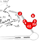
As a result, the sanctuary and surrounding waters
are a hot spot for collisions between commercial
ships and whales. During 2004-2006, scientists from
the SBNMS and NOAA Fisheries (Northeast Science
Center) investigated ways to reduce the risk of
collisions between endangered whales and commercial
ships within the sanctuary. This analysis revealed
that the current Traffic Separation Scheme (TSS)
through the sanctuary routed shipping over high
density whale areas. Analysis further revealed that
a small northward shift could move the TSS into
low density areas and reduce the risk of vessel
collision to North Atlantic right whales by as much
as 58% and to all baleen whales by as much as 81%.
|
|
|
 |
|
SURVEY
OF HUMAN ACTIVITIES AND MARINE MAMMALS
One of the first steps in determining how
to best manage national marine sanctuaries
and their resources is monitoring, assessing
and understanding changes in and threats to
these areas.
|
In
July, 2001, the SBNMS undertook a year-long study
to quantify and map the spatial and temporal densities
of fixed and mobile gear fishing effort and baleen
whale sightings. These data were used to depict
the "user geography" of the SBNMS and
alert managers to areas where intense co-occurrence
might signal potential harm to sanctuary resources.
Identifying such areas of concern are a vital first
step for initiating mitigation measures, as well
as facilitating dialogues and information exchange
between interest groups seeking solutions to the
problem.
|
|
|
 |
|
WHALE
WATCHING GUIDELINES
Voluntary operational guidelines have been
established by the whale watching industry
in the northeast region of the United States,
in cooperation with government agencies and
non-profit conservation organizations.
|
To measure compliance with the speed aspect of the
guidelines, the SBNMS places inconspicuous observers
onboard thirty-five commercial whale watching trips
that occurred in and around the SBNMS. Observations
were made from August to October 2003. Compliance
was evaluated by creating guideline specified speed
zone buffers around the sighted whales and overlaying
the with the vessel track and speed data. Results
indicated that whale watching vessels often ignored
speed zone guidelines and that the degree of non-compliance
increased as distance from the whale(s) increased.
|
|
|
 |
|
COMMERCIAL
SHIPPING AND RIGHT WHALE ADVISORY ZONES
Ship collision is a major mortality threat
to the endangered North Atlantic right whale.
To mitigate this threat, NOAA Fisheries initiated
the Right Whale Sighting Advisory System (RWSAS)
that designates advisory zones around right
whale sightings.
|
Researchers at the SBNMS collaborated with managers
at NOAA Fisheries (Northeast Science Center) to
analyze data from the US Coast Guard's Universal
Shipborne Automatic Identification System (AIS),
to quantify and assess the behavior of commercial
vessels relative to advisory zones, and to make
recommendations as to how the RWSAS can better meet
its conservation goals.
|
|
|
 |
|
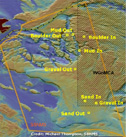
MOVEMENT
OF ATLANTIC COD
Atlantic cod populations in the Gulf of Maine
have been exploited commercially for several
hundred years, and continue to be heavily
exploited today.
|
The successful conservation and management of cod
in the Gulf of Maine, and at the scale of the Stellwagen
Bank National Marine Sanctuary (SBNMS) in particular,
is highly dependent on this information. Scientists
from NOAA, Pfleger Institute of Environmental Research
(PIER) and the National Undersea Research Center
at the University of Connecticut (NURC-UCONN) are
collaborating on a research project that is using
acoustic telemetry technology to quantify cod movement
over different features of the landscape to inform
management of the SBNMS and the greater Gulf of
Maine region. The high site fidelity of many cod
to individual piled boulder reefs suggests that
habitat-specific management measures, such as marine
reserves, may offer significant protection to cod
within the sanctuary.
|
|
|
 |
|
SEAFLOOR
HABITAT RECOVERY MONITORING PROGRAM
The southwest corner of the Western Gulf of
Maine Closed Area (WGoMCA), which overlaps
the SBNMS for a total of 132 square nautical
miles, or 22% of the Sanctuary, presented
the opportunity to study seafloor habitat
recovery following anthropogenic disturbance
by bottom-contact mobile fishing gear (such
as trawls and dredges).
|
The
Seafloor Habitat Recovery Monitoring Project (SHRMP)
was initiated in April 1998, one week prior to the
closure of the WGoMCA, to investigate the recovery
rates in the SBNMS following impacts from fishing.
In August 2001, several sites along the route of
a new fiber optic cable and in adjacent areas were
added to the existing SHRMP stations to investigate
the recovery of seafloor habitats following the
laying of the cable by plow. The SHRMP is a collaborative
effort between the SBNMS and scientists at the Pfleger
Institute of Environmental Research (PIER), the
National Undersea Research Center at the University
of Connecticut (NURC-UCONN), the US Geological Survey
in Woods Hole, Massachusetts, the University of
Maine, and Brown University (Brown participated
from 2001-2003), with database management provided
by Perot Systems.
|
|
|
 |
|
LARGE
MARINE MAMMAL DATABASE
In 2001, NOAA contracted Perot Systems to
support the SBNMS in the development of a
relational database collecting and integrating
data on the distribution of marine mammals
in the sanctuary.
|
To
complete this task, Perot partnered with the Provincetown
Center for Coastal Studies and the Whale Center
of New England, as these organizations have access
to over twenty years of marine mammal observations
in the Gulf of Maine.The five year contract resulted
in a database describing the temporal and spatial
distribution of multiple species of marine mammals
in the sanctuary, representing over 350,000 individual
sightings recorded over a twenty five year period
(1979-2004).
|
|
|
Monitoring
negative anthropogenic effects on the endangered
whales and evaluating current regulations and management
strategies is essential in order to reduce potential
contributing factors to the survival of populations
and species. Since 2002, a systematic research effort
involving SBNMS and NOAA Fisheries (Northeast Region)
in collaboration with Fuji Film U.S.A. Inc. and
the Advanced Imaging and Visualization Laboratory
at the Woods Hole Oceanographic Institution has
employed high performance digital imaging capabilities
with the use of the Fuji Airship as an aerial monitoring
platform. This opportunity has allowed for ongoing
aerial data collection off coastal waters of the
northeastern and southern United States, analysis
of whale distribution in and around shipping lanes,
and compliance with whale watching guidelines.
|
|
|

|
|


 ) - please view our