Maps and Data
Find maps and charts showing transportation data and trends related to alternative fuels and vehicles.
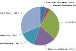
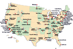
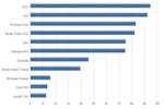
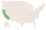
Liquefied Natural Gas Fueling Stations by State
| State | # Public Stations |
| Nevada | 1 |
| Texas | 5 |
| Louisiana | 1 |
| Ohio | 1 |
| Alabama | 1 |
| California | 13 |
| Utah | 3 |
| Wisconsin | 1 |
| Connecticut | 1 |
| Arizona | 1 |
| Alaska | 0 |
| Arkansas | 0 |
| Colorado | 0 |
| Delaware | 0 |
| Florida | 0 |
| Georgia | 0 |
| Hawaii | 0 |
| Idaho | 0 |
| Illinois | 0 |
| Indiana | 0 |
| Iowa | 0 |
| Kansas | 0 |
| Kentucky | 0 |
| Maine | 0 |
| Maryland | 0 |
| Massachusetts | 0 |
| Michigan | 0 |
| Minnesota | 0 |
| Mississippi | 0 |
| Missouri | 0 |
| Montana | 0 |
| Nebraska | 0 |
| New Hampshire | 0 |
| New Jersey | 0 |
| New Mexico | 0 |
| New York | 0 |
| North Carolina | 0 |
| North Dakota | 0 |
| Oklahoma | 0 |
| Oregon | 0 |
| Pennsylvania | 0 |
| Rhode Island | 0 |
| South Carolina | 0 |
| South Dakota | 0 |
| Tennessee | 0 |
| Vermont | 0 |
| Virginia | 0 |
| Washington | 0 |
| West Virginia | 0 |
| Wyoming | 0 |
Several regions in the United States have fueling stations that provide liquefied natural gas (LNG). Roll over a state on the map for count of LNG stations. To map LNG stations near a specific address or city, use the Alternative Fueling Station Locator. Total station counts for all alternative fuels are updated monthly.