
Volcano Hazards Program Webcams
Below is a list of webcams of U.S. volcanoes. All webcams are operated by the USGS, unless otherwise noted.The images below are not the webcams but links to the webcams. The images were taken in the past by cameras and are meant to show the approximate area, not necessarily the view from the webcam.
-
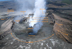
Pu`u `O`o vent, Kilauea Volcano (HVO)
-

Halema`uma`u from HVO,
Kilauea Volcano (HVO) -

Halema`uma`u from
overlook, Kilauea
Volcano (HVO) -
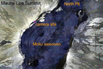
Moku`aweoweo, Mauna
Loa Summit Caldera (HVO) -

Thanksgiving Eve Breakout
From Pu`u `O`o vent, Kilauea
Volcano (HVO) -

USDA Forest Service - Mount St.
Helens Crater -

Redoubt, Alaska (AVO), approximately
7.5 mi (12 km) from Redoubt's summit
crater. This camera provides a view of
the north flank of Redoubt. -

Redoubt, Alaska (AVO), approximately
38 miles SE of Mt. Spurr -

Akutan, Alaska (AVO)
-

Augustine from Homer, Alaska (AVO)
-

Augustine Island, Alaska (AVO)
-

University of Alaska Geophysical
Institute Augustine camp on the
west side of the island, Alaska (AVO) -

Near Infrared (NIR) Augustine, Alaska
- best during low light (AVO) -

Mount Cleveland, Alaska (AVO)
-

Fourpeaked Volcano, Alaska (AVO)
-

Katmai, Alaska (AVO)
-

Pavlof Volcano, Alaska (AVO)
-

Peulik, Alaska (AVO)
-

Mount Spurr, Alaska (AVO)
-

Mount Spurr, Alaska from station
CKT (AVO) -

Veniaminof Volcano, Alaska (AVO)
-

Anatahan Volcano, Northern Mariana Islands (AVO)
