Posts Tagged ‘Earth’

My Big Fat Planet: In Essence: Science Boiled Down

Thursday, January 10th, 2013

By Amber Jenkins

Map of the Arctic Sea and environs

An interesting recent paper from Dr. Son Nghiem at NASA’s Jet Propulsion Laboratory and colleagues finds that the bottom of the Arctic Ocean controls the pattern of sea ice thousands of feet above on the water’s surface. The seafloor topography exerts its control not only locally, in the Bering, Chukchi, Beaufort, Barents and Greenland Seas, but also spanning hundreds to thousands of miles across the Arctic Ocean.

How? The seafloor influences the distribution of cold and warm waters in the Arctic Ocean where sea ice can preferentially grow or melt. Geological features on the ocean bottom also guide how the sea ice moves, along with influence from surface winds.

Interestingly, the study also links the bottom of the Arctic Ocean with cloud patterns up in the sky. The ocean bottom affects sea ice cover, which affects the amount of vapor coming from the surface of the ocean out into the air, which in turn influences cloud cover.

The researchers, who also come from NASA’s Goddard Space Flight Center, the Applied Physics Laboratory and the National/Naval Ice Center in the U.S., use sea ice maps taken from space with NASA’s QuickSCAT satellite, as well as measurements from drifting buoys in the Arctic Ocean. They compare the sea ice and seafloor topography patterns to identify the connection between the two.

Bottom line:

Since the seafloor does not change significantly over many years, sea ice patterns can form repeatedly and persist around certain underwater geological features. So computer models need to incorporate these features in order to improve their forecasts of how ice cover will change over the short- and long-term. This ‘memory’ of the underwater topography could help refine our predictions of what will happen to ice in the Arctic as the climate changes.

Source:

Seafloor Control on Sea Ice,” S. V. Nghiem, P. Clemente-Colon, I.G. Rigor, D.K. Hall & G. Neumann, Deep Sea Research Part II: Topical Studies in Oceanography, Volumes 77-80, pp 52-61 (2012).

This post was written for “My Big Fat Planet,” a blog hosted by Amber Jenkins on NASA’s Global Climate Change site.


My Big Fat Planet: Pick of the Pics

Thursday, January 10th, 2013

By Amber Jenkins

View of Earth at Night    Earth at night, as seen by the Suomi National Polar-orbiting Partnership (NPP) satellite, a joint effort by NASA and the National Oceanic and Atmospheric Administration (NOAA). Courtesy of NASA Earth Observatory and NOAA National Geophysical Data Center.

This is a new image of our planet at night, as taken by a new NASA and National Oceanic and Atmospheric Administration (NOAA) satellite orbiting above us. Scientists recently unveiled this global composite image (and the one below), constructed using cloud-free nighttime images. They show the glow of natural and man-made phenomena across the planet in greater detail than ever seen before. City lights can tell us about how humans have spread across the globe.

View of Earth at Night

Many satellites are equipped to look at Earth during the day, when they can observe our planet fully illuminated by the sun. But with a new sensor onboard the NASA-NOAA Suomi National Polar-orbiting Partnership (NPP) satellite launched last year, scientists now can observe Earth’s atmosphere and surface during nighttime hours.

For more Earth at night images, see this article.

This post was written for “My Big Fat Planet,” a blog hosted by Amber Jenkins on NASA’s Global Climate Change site.


In a State of Flux

Thursday, September 1st, 2011

By Amber Jenkins

This post was written for My Big Fat Planet, a blog hosted by Amber Jenkins on NASA’s Global Climate Change site.

Latest Image of Vesta captured by Dawn on July 17, 2011
COLD SNAP: Petermann Glacier, Greenland. Left: June 26, 2010. Right: August 13, 2010. An iceberg more than four times the size of Manhattan broke off the Petermann Glacier (the curved, nearly vertical stripe stretching up from the bottom right of the images) along the northwestern coast of Greenland. Warmer water below the floating ice and at the sea’s surface were probably responsible for the break.
› See more images of our changing Earth from State of Flux

They say a picture says a thousand words. This week we published our 100th image in State of Flux, our gallery showing images of change around our planet. So hopefully by now you’re in awe of our home planet and the ways in which it is constantly changing, and aware of the impact us humans can have.

Each week for the past couple of years, we’ve published new images of different locations on planet Earth, showing change over time periods ranging from centuries to days. The pictures have been taken from space, by NASA’s Eyes on the Earth (its fleet of satellites whizzing above our heads), and from the ground, by real-life people. Some of the changes seen are related to, or exacerbated by, climate change, and some are not. Some document the effects of urbanization and man’s impact on the land, while others the ravage of disasters such as fires and floods.

Seeing our planet from space gives us a global view that we can’t get elsewhere. Through those eyes, we’ve witnessed damage caused by the recent tsunami in Japan, glacier melt in the Himalayas, the greening of China, the growth of Las Vegas and a century of global warming. We’ve looked at the march of deforestation in Bolivia, the rumblings of the (unpronounceable) Icelandic volcano Eyjafjallajökull, and the damming of the River Nile. Take a look below at some of our favorites. Sign up to our monthly newsletter or subscribe to our Facebook page if you want to keep up to date with our latest images. We’ll be launching a brand spanking new version of the gallery soon!

See more of some of the most stunning images from State of Flux on My Big Fat Planet.


Unchained Goddess: Frank Capra Knew

Monday, December 6th, 2010

By Amber Jenkins

a screen grab from The Unchained Goddess

You might think from the amount of “climate science debate” that is given airtime in the U.S. media that it’s undiscovered territory. But it’s not. The science is very well established and goes back a long way. Global warming is not a new concept.

The Victorians knew about it. John Tyndall (born 1820) knew about it. So did Svante August Arrhenius. In April 1896, Arrhenius published a paper in the London, Edinburgh and Dublin Philosophical Magazine and Journal of Science entitled “On the influence of carbonic acid in the air upon the temperature of the ground.” (Arrhenius referred to carbon dioxide as “carbonic acid” in accordance with the convention of the time.)

Arrhenius’ paper was the first to quantify how carbon dioxide contributed to the greenhouse effect — carbon dioxide warms up the Earth by trapping heat near the surface, a bit like swaddling the planet in an extra blanket. Arrhenius was also the first to speculate about whether changes in the amount of carbon dioxide in the atmosphere have contributed to long-term variations in Earth’s climate. He later made the link between burning fossil fuels and global warming.

Another person who “knew” some time ago was Frank Capra. Graduating from Caltech in 1918, he went on to become a famous filmmaker responsible for “It’s a Wonderful Life” and other movies. But one that stands out, at least for nerds like me or people with an interest in climate change is “Meteora: The Unchained Goddess”, released in 1958:

Made for Bell Labs, this most awesome educational film speaks of “extremely dangerous questions”:

Dr. Frank C. Baxter: “Because with our present knowledge we have no idea what would happen. Even now, man may be unwittingly changing the world’s climate through the waste products of his civilization. Due to our release through factories and automobiles every year of more than six billion tons of carbon dioxide, which helps air absorb heat from the sun, our atmosphere seems to be getting warmer.”

Richard Carlson: “This is bad?”

Dr. Frank C. Baxter: “Well, it’s been calculated a few degrees rise in the Earth’s temperature would melt the polar ice caps. And if this happens, an inland sea would fill a good portion of the Mississippi valley. Tourists in glass bottom boats would be viewing the drowned towers of Miami through 150 feet of tropical water. For in weather, we’re not only dealing with forces of a far greater variety than even the atomic physicist encounters, but with life itself.”

In 1958, they knew about the effects of heating up the planet. In the 1800s they knew about it. Today, the biggest challenge facing climate scientists lies in predicting how much our climate will change in the future. It’s not a trivial task, given how complicated the climate system is — we can barely predict in detail more than a week’s worth of weather. We’re not viewing Miami through bottomed-glass boats yet, but we’re already beginning to see some of the predictions of global warming — melting sea and land ice, sea level rise, more extreme weather events, changes in rainfall and effects on plants and animals — be borne out.

Thanks to OSS and Discovery News for the tip.

This post was written for “My Big Fat Planet,” a blog hosted by Amber Jenkins on NASA’s Global Climate Change site.


Taking On Water Resource Issues

Friday, October 15th, 2010

By Stephanie Granger

water resources

Worldwide today, it is estimated that nearly 1.1 billion people live without access to adequate water supplies and about 2.6 billion people lack adequate water sanitation. Improved understanding of water processes at global and regional scales is essential for sustainability.

Researchers at JPL recently launched the Western Water Resource Solutions website to highlight activities that apply NASA expertise and data to water resource issues in the western United States.

One focus area for this new site is the hydrologic cycle and using global satellite observations of the Earth to improve our understanding of water processes on a regional and local level. The western United States is expected to bear the brunt of impacts to water resource availability because of changing precipitation patterns, increasing temperatures, and a growing population. California is already starting to feel the impacts and is taking action to develop new adaptive management practices to ensure a safe and reliable water supply, while maintaining healthy ecosystems throughout the state.

NASA researchers at Ames Research Center, the Jet Propulsion Laboratory, and Marshall Space Flight Center are currently working with water managers to apply NASA expertise and data to water resource issues in California. The project partners with universities, agencies and other stakeholders, to utilize information from a number of sources, including existing ground observations and models.

This project is only one of several NASA initiatives aimed at providing actionable scientific information on water quality and the water balance worldwide. These other projects include development of better estimates of snow pack, groundwater monitoring, soil moisture and evapotranspiration, water quality, and monitoring fragile levee systems.

In addition to raising awareness about current water resource challenges, the new website highlights NASA’s capability to use satellite and airborne data to help solve some of these challenges.

Learn more about the Western Water Resource Solution Group at: http://water.jpl.nasa.gov/


Written as part of Blog Action Day 2010


Comets and Life On Earth

Monday, August 17th, 2009
Donald Yeomans
Donald Yeomans

With the recent discovery of the amino acid glycine in the comet dust samples returned to Earth by the Stardust spacecraft, it is becoming a bit more clear how life may have originated on Earth. Water is a well-known ingredient in both comets and living organisms, and now it appears that amino acids are also common to comets and living organisms. Amino acids are used to make proteins, which are chains of amino acids, and proteins are vital in maintaining the cell structures of plants and animals.

Amino acids had previously been identified in meteorite samples, and these samples are thought to be the surviving fragments from asteroid collisions with the Earth. So now it appears that both comets and asteroids in the Earth’s neighborhood, the so-called near-Earth objects, delivered some of the building blocks of life to the early Earth.

Asteroid Eros - Mosaic of Northern Hemisphere
Asteroid Eros - Mosaic of Northern Hemisphere. Image Credit: NASA/JPL/JHUAPL
› Full image and caption

Impacts of comets and asteroids with the early Earth likely laid down the veneer of carbon-based molecules and water that allowed life to form. Once life did form, subsequent collisions of these near-Earth objects frustrated the evolution of all but the most adaptable species. The dinosaurs checked out some 65 million years ago because of an impact by a six mile-wide comet or asteroid off the coast of the Yucatan peninsula. Fortunately, the small, furry mammalian creatures at the time were far more adaptable and survived this impact event. Thus, present day mammals like us may owe our origin and current position atop Earth’s food chain to these near-Earth objects, one of which took out our dinosaur competitors some 65 million years ago.

Today, most of the attention directed toward near-Earth objects has to do with the potential future threat they can pose to life on Earth. However, the recent Stardust discovery of a cometary amino acid reminds us that, were it not for past impacts by these objects, the Earth may not have received the necessary building blocks of life, and humans may not have evolved to our current preeminent position on Earth. While giving thanks to these near-Earth objects, we still need to make sure we find the potentially hazardous comets and asteroids early enough so we don’t go the way of the dinosaurs.

For more information on near-Earth objects, see: http://www.jpl.nasa.gov/asteroidwatch/index.cfm


Five Things About Viewing Mars in August

Thursday, August 6th, 2009
Jane Houston Jones
Jane Houston Jones

Updated Aug. 26, 2010

If you’re like me, you may have received an e-mail this summer telling you to go outside on August 27 and look up in the sky. The e-mail, most likely forwarded to you by a friend or relative, promises that Mars will look as big as the moon on that date and that no one will ever see this view again. Hmmm, it looks like the same e-mail I received last summer and the summer before that, too. In fact this same e-mail has been circulating since 2003, but with a few important omissions from the original announcement.

I’m Jane Jones, an amateur astronomer and outreach specialist for the Cassini mission at Saturn, and I’m here to set the record straight on when and how you can actually see Mars this month.

1. How did the “Mars in August” e-mail get started in the first place?

In 2003, when Mars neared opposition — its closest approach to Earth in its 22-month orbit around the sun — it was less than 56 million kilometers (less than 35 million miles) away. This was the closest it had been in over 50,000 years. The e-mail that circulated back then said that Mars, when viewed through a telescope magnified 75 times, would look as large as the moon does with the unaided eye. Even back in 2003, to the unaided eye, Mars looked like a reddish star in the sky to our eyes, and through a backyard telescope it looked like a small disc with some dark markings and maybe a hint of its polar ice cap. Without magnification, it never looked as large as the moon, even back in 2003!

August 2010 sky map

2. Can the moon and Mars ever look the same size?

No. The moon is one-quarter the size of Earth and is relatively close — only about 384,000 kilometers (about 239, 000 miles) away. On the other hand, Mars is one-half the size of Earth and it orbits the sun 1-1/2 times farther out than Earth’s orbit. The closest it ever gets to Earth is at opposition every 26 months. The last Mars opposition was in January and the next one is in March 2011.

At opposition, Mars will be 101 million kilometers (63 million miles) from Earth, almost twice as far as in 2003. So from that distance, Mars could never look the same as our moon.

3. Is Mars visible in August 2010?

Mars and Saturn made a dramatic trio with brighter Venus this month. Skywatchers enjoyed seeing the three planets closely gathered on the 12th and 13th with the slender crescent moon nearby. On the 27th, you’ll see Venus shining brightly in the west. If you look above Venus, you may find faint Mars. Saturn is barely visible above the horizon, getting ready for its solar conjunction next month.

4. Can I see Mars and the moon at the same time this month?

Both the moon and Mars were next to one another on the 12th and 13th, but now you can see both planets a few hours apart. Look for Mars in the west at sunset, and watch the moon rise in the east a few hours later. On August 26th and 27th you can see the nearly full moon rising in the east at about 10 p.m. The bright planet below the moon on the 26th is Jupiter! On the 27th, the moon is to the left of the planet.

5. Will the “Mars in August” e-mail return next year?

Most certainly! But next year, you’ll be armed with facts, and perhaps you will have looked at the red planet for yourself and will know what to expect. And you will know exactly where to put that email. In the trash!


Five Things About Hurricanes

Wednesday, July 1st, 2009
Bjorn Lambrigtsen
Bjorn Lambrigtsen

JPL scientist Bjorn Lambrigtsen goes on hurricane watch every June. He is part of a large effort to track hurricanes and understand what powers them. Lambrigtsen specializes in the field of microwave instruments, which fly aboard research planes and spacecraft, penetrating through thick clouds to see the heart of a hurricane.

While scientists are adept at predicting where these powerful storms will hit land, there are crucial aspects they still need to wrench from these potentially killer storms.

Here are thoughts and factoids from Lambrigtsen in the field of hurricane research.

1. Pinpointing the moment of birth

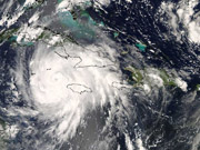
Hurricane Gustav
Hurricane Gustav moved along the southern side of Jamaica on Aug. 29, 2008. Image credit: NASA MODIS Rapid Response

Most Atlantic hurricanes start as a collection of thunderstorms off the coast of Africa. These storm clusters move across the Atlantic, ending up in the Caribbean, Gulf of Mexico or Central America. While only one in 10 of these clusters evolve into hurricanes, scientists do not yet know what triggers this powerful transformation.

Pinpointing a hurricane’s origin will be a major goal of a joint field campaign in 2010 between NASA and the National Oceanic and Atmospheric Administration (NOAA).

2. Predicting intensity

Another focus of next year’s research campaign will be learning how to better predict a storm’s intensity. It is difficult for emergency personnel and the public to gauge storm preparations when they don’t know if the storm will be mild or one with tremendous force. NASA’s uncrewed Global Hawk will be added to the 2010 research armada. This drone airplane, which can fly for 30 straight hours, will provide an unprecedented long-duration view of hurricanes in action, giving a window into what fuels storm intensity.

3. Deadly force raining down

Think about a hurricane. You imagine high, gusting winds and pounding waves. However, one of the deadliest hurricanes in recent history was one that parked itself over Central America in October 1998 and dumped torrential rain. Even with diminished winds, rain from Hurricane Mitch reached a rate of more than 4 inches per hour. This caused catastrophic floods and landslides throughout the region.

4. Replenishing “spring”

Even though hurricanes can wreak havoc, they also carry out the important task of replenishing the freshwater supply along the Florida and southeastern U.S. coast and Gulf of Mexico. The freshwater deposited is good for the fish and the ecological environment.

5. One size doesn’t fit all

Hurricanes come in a huge a variety of sizes. Massive ones can cover the entire Gulf of Mexico (about 1,000 miles across), while others are just as deadly at only 100 miles across. This is a mystery scientists are still trying to unravel.

NASA and NOAA conduct joint field campaigns to study hurricanes. The agencies use research planes to fly through and above hurricanes, and scientists collect data from NASA spacecraft that fly overhead. NOAA, along with its National Hurricane Center, is the U.S. government agency tasked with hurricane forecasting.

For more information on how NASA and JPL study hurricanes, go to www.nasa.gov/hurricane and http://tropicalcyclone.jpl.nasa.gov