
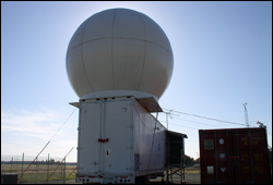


SkyWater Radar
|
HMT-West Overview
HMT-West is the first regional demonstration of the Hydrometeorology Testbed strategy. It developed as an outgrowth of NOAA's CALJET and PACJET projects (1997-2003), which were aimed at improving short-term forecasting of land-falling storms impacting the west coast of the U.S. Intense precipitation associated with these storms often brings challenges to regional water managers attempting to balance the need for water supply storage and flood mitigation.
Field Experiments
Related Projects
- CalWater: Our current understanding of heavy precipitation events and how precipitation will change in a changing climate is hampered by incomplete scientific knowledge. Taking advantage of the infrastructure and knowledge gained through HMT-West, Science leaders from the California Energy Commission, NOAA, and Scripps Institution of Oceanography are identifying gaps, developing strategies, and assisting CEC in planning for a possible follow-up field study.
- HMT-West Legacy: An agreement between NOAA and the California Department of Water Resources has led to the deployment of additional instrumentation across the HMT-West domain for long term monitoring of soil moisture, water vapor, precipitation, and snow level across the state of California. These instruments will be deployed in stages over a period of years beginning in 2009. Over time, these observations will create an important climate record and datasets to verify model QPF and improve overall forecast skill.