Massachusetts Real-Time Groundwater Level Network
Hover mouse over site for information.
Map generated 2/15/2013 8:19:43 AM
Note: Color shading in the table below indicates multiple wells that plot as a single point on the state location map above.
Note: BLS = Water Level in Feet Below Land Surface, AVD = Water Level in Feet Above Vertical Datum
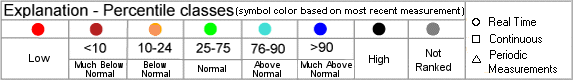
Map Site ID Site Name Most Recent Date Well Local Aquifer 413801070322703 MA-FSW 239-0121 6.90 BLS 2/13/2013 121.0 Outwash 414124070311401 MA-SDW 527-0055 (90MW0063) 16.16 BLS 2/13/2013 55.0 Outwash 414139070311501 MA-SDW 526-0040 (MW-145S) 29.49 BLS 2/13/2013 40.0 Outwash 414159070310501 MA-SDW 537-0107 SANDWICH, MA 96.47 BLS 2/13/2013 106.7 Outwash 414219070313601 MA-SDW 525-0109 (MW-126S) 99.87 BLS 2/13/2013 109.0 Outwash 414630070014901 MA-BMW 22 BREWSTER, MA 31.98 BLS 2/13/2013 52.0 Outwash 414714071175901 MA-SHW 275 SEEKONK, MA 5.20 BLS 2/12/2013 14.4 Outwash 415228070554601 MA-LKW 14 LAKEVILLE, MA 16.04 BLS 2/13/2013 41.0 Ice-contact Deposits, Including Eskers And Kames 415353069585401 MA-WNW 17 WELLFLEET, MA 12.18 BLS 2/12/2013 42.0 Outwash 420321070433502 MA-D4W 79 DUXBURY, MA 7.85 BLS 2/13/2013 23.5 Outwash 420545071174001 MA-NNW 27 NORFOLK, MA 6.00 BLS 2/13/2013 18.4 Outwash 421852071220501 MA-WKW 2 WAYLAND, MA 15.87 BLS 2/13/2013 33.0 Outwash 422103072241102 MA-PDW 23 PELHAM, MA 16.64 BLS 2/13/2013 740.0 Bedrock 422341071464901 MA-WSW 26 WEST BOYLSTON, MA 5.69 BLS 2/12/2013 16.8 Stratified Deposits, Undifferentiated 422745073112001 MA-PTW 51 PITTSFIELD, MA 16.48 BLS 2/13/2013 31.5 Ice-contact Deposits, Including Eskers And Kames 422812071244401 MA-ACW 158 ACTON, MA 19.51 BLS 2/13/2013 33.8 Ice-contact Deposits, Including Eskers And Kames 422906072124301 MA-PHW 16 PETERSHAM, MA 12.15 BLS 2/13/2013 39.0 Till 423115071032001 MA-WAW 38 WAKEFIELD, MA 6.58 BLS 2/13/2013 25.5 Ice-contact Deposits, Including Eskers And Kames 423401071093801 MA-XMW 78 WILMINGTON, MA 8.30 BLS 2/13/2013 12.0 Ice-contact Deposits, Including Eskers And Kames
Return to National Page * References to non-Department of the Interior (DOI) products do not constitute an endorsement by the DOI.TERMS . 
 Groundwater Watch Help Page
 1
1  2
2  7
7  9
9  13
13  15
15  17
17 