 |
 |
 |
 |
 |
|
|
Using Google Earth to Explore Estuaries
Introduction
Google Earth is a virtual globe web site that lets people fly around Earth, zooming in for details or zooming out for a broad perspective. Google Earth uses satellite imagery, aerial photography and a 3D globe, putting the world’s geographic information at your fingertips. With Google Earth, you can:
- Fly to any location. Just type in an address, press Search, and you will zoom right in.
- Search different types of terrain and study geologic and estuary features from any altitude.
- Tilt and rotate the view to see 3D terrain.
- Save your searches and image data for future use.
Google Earth is a powerful tool for exploring your world. In your study of estuaries, it can be used to reveal the relationships among landforms, water features, towns, cities, and the habitats of the animals and plants that live in estuaries.
Access Google Earth
- Once you download and install Google Earth, your computer becomes a window to anywhere, allowing you to view high-resolution aerial and satellite imagery, photos, elevation terrain, road and street labels, business listings, and more.
- Access a user guide to learn Google Earth basics - navigating the globe, searching, printing, and more.
Navigating Estuaries through the use of Google Earth
Finding an Initial Starting Point or Location
To explore a region of Earth, you must first locate it in Google Earth. There are several ways to do this. One way is just to click on the general area you are interested in when the world map is displayed. After the selected region is centered on the screen, the slider displayed in the upper right hand corner of the screen can be used to zoom in. The hand tool can then be used to re-center the image or to move around the region.
If you don't know the position on a map of a certain location, you can use the search feature of Google Earth. When you open program, you will see the word "Search" in the upper left hand corner of the screen. Below the word Search is a tab that says "Fly To." After you click on Fly To, type either the name of the location (i.e. Miami, FL, Alabama River), or the exact latitude and longitude of the location. If you write in the latitude and longitude, do not use degree symbols. Instead, write the latitude and longitude using the following format to indicate the number of degrees, minutes, and seconds. Add the appropriate symbol for N or S after the latitude reading, and W or E after the longitude reading.
Example: To fly to Miami, FL = 25o 43' 36.98 N, 80o 14' 09.90 W
Moving From Place to Place Within a Region
Once you have a starting point established, you may want to zoom in to see objects in detail or zoom out to see the big picture. To zoom in, double click on a point in the image you are interested in. You will zoom in toward the object you clicked on. To move closer, place your cursor over the North symbol in the upper right corner of the screen. You will see four directional arrowheads and two sliders, one vertical, and one horizontal appear on the screen. To zoom in, grab the vertical slider and move it toward the top of the screen; to zoom out, move it downward.
To move from place to place, you can use the four arrow heads (see figure below) on the screen to move north, south, east, or west, or simply hold your mouse button down and use your cursor to move about the image.
From time to time, you will be asked to view an area from a certain height above the ground. In Google Earth this is called "Eye Altitude." To adjust your Eye Altitude, zoom in or out until the required height, measured in kilometers, is displayed on the screen in the lower right-hand corner.

The Tijuana River from an altitude of 4 km. Notice the Eye altitude reading in the lower right-hand corner.
Google Earth also allows you to view terrain at an angle, which essentially will produce a 3-dimensional view of the region you are studying. To use this feature, grab the horizontal slider and move it to the right or left to give you different views of the terrain you are studying.
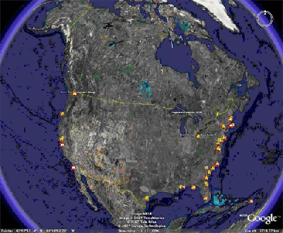
Finding NERRS Estuaries
A map of the United States has been marked with the location of all National Estuarine Research Reserves. To find one nearest your location, open up the Reserves.kmz/Google Earth program. Make sure that terrain and geographic features are checked under Layers. Look for circles or pins that indicate the location of NERRS sites. Double click on one that interests you. You can then zoom in and investigate the reserve you have chosen.
Resolution
Each image in Google Earth is actually a composite of hundreds of separate images taken from many sources and at different times. As you explore different regions of Earth, you may see changes in color and image clarity at the borders of areas covered by different types of images sources. You may also run into “blurry” areas as you pan up the coast. For example, in the image of the Alabama River below, you see the color of the river change to different shades of brown. These colors are not due to the sudden changes in the quality of the river water. Instead they are due to differences in the individual images that make up the larger composite image.

When you zoom in on one of these water-color boundaries, you can see that the sharpness, or resolution, of the images on either side of the boundary is different. Also, images may be taken with different filters covering the lens. This leads to a somewhat different color scheme, resulting in the types of changes you see below in the color of certain features like river water.
In your investigations, the quality and resolution of the individual images may vary widely. Keep this in mind when going in for a closer look at landscape and man-made features.
Last Updated on: 07-18-2008
|
|
|
|
|