Severe Weather 101
Tornado Types
Tornadoes come from mainly two types of thunderstorms: supercell and non-supercell.
Tornadoes that come from a supercell thunderstorm are the most common, and often the most dangerous. A rotating updraft is a key to the development of a supercell, and eventually a tornado. There are many ideas about how this rotation begins. One way a column of air can begin to rotate is from wind shear – when winds at two different levels above the ground blow at different speeds or in different directions.
An example of wind shear that can eventually create a tornado is when winds at ground level, often slowed down by friction with the earth's surface, come from the southwest at 5 mph. But higher up, at 5000 feet above the same location, the winds are blowing from the southeast at 25 mph! An invisible “tube” of air begins to rotate horizontally. Rising air within the thunderstorm tilts the rotating air from horizontal to vertical – now the area of rotation extends through much of the storm.
Once the updraft is rotating and being fed by warm, moist air flowing in at ground level, a tornado can form. There are many ideas about this too.
Scientists still have many questions. As few as 20 percent of all supercell thunderstorms actually produce tornadoes. Why does one supercell thunderstorm produce a tornado and another nearby storm does not? What are some of the causes of winds moving at different speeds or directions that create the rotation? What are other circulation sources for tornadoes? What is the role of downdrafts (a sinking current of air) and the distribution of temperature and moisture (both horizontally and vertically) in tornadogenesis?
And, since not all tornadoes come from supercells, what about tornadogenesis in non-supercell thunderstorms?
Non-supercell tornadoes are circulations that do not form from organized storm-scale rotation. These tornadoes form from a vertically spinning parcel of air already occurring near the ground caused by wind shear from a warm, cold, or sea breeze front, or a dryline. When an updraft moves over the spinning, and stretches it, a tornado can form. Eastern Colorado experiences non-supercell tornadoes when cool air rushes down off the Rocky Mountains and collides with the hot dry air of the plains. Since these types of tornadoes happen mostly over scarcely populated land, scientists are not sure how strong they are, but they tend to be small.
One non-supercell tornado is the gustnado, a whirl of dust or debris at or near the ground with no condensation funnel, which forms along the gust front of a storm.
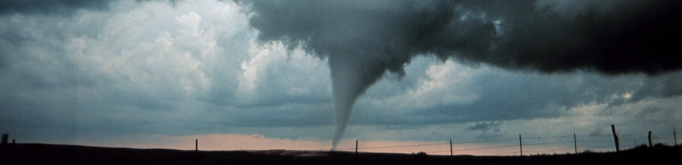
Another non-supercell tornado is a landspout. A landspout is a tornado with a narrow, rope-like condensation funnel that forms while the thunderstorm cloud is still growing and there is no rotating updraft - the spinning motion originates near the ground.
Waterspouts are similar to landspouts, except they occur over water. Damage from these types of tornadoes tends to be EF2 or less.