
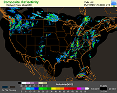
NMQ is a powerful research and development tool for the creation of new techniques to estimate and forecast precipitation amounts, locations and types. [+]
![[+]](https://webarchive.library.unt.edu/web/20130214230853/http://www.nssl.noaa.gov/research/flood/images/nmq.png)

Observations of flash flooding have been combined into a consistent framework for the research community. The observations come from spotter reports from the National Weather Service, public survey responses from NSSL's SHAVE project, and from the entire archive of USGS stream gauging stations.

CI-FLOW stream-flow simulations are linked to inundation maps showing the expected extent and depth of water for a given river flood stage.
NSSL contributed to a joint NOAA/USGS demonstration flash flood and debris flow early warning system, to help forecasters improve flash flood and debris flow warnings in areas damaged by wildfires.
Research: Flooding
Flash floods are a worldwide hazard, and are the number one hazardous weather related killer in the United States. They occur when heavy rainfall in a short period of time causes water to rapidly rise. NSSL researchers include hydrologists and hydrometeorologists to address the complicated problem of forecasting and warning for these events.
Flooding Research Areas
NSSL researchers investigate the meteorological causes of flash flooding and working on tools to improve the science behind flood forecasts and warnings.
Forecasting Precipitation Amounts
NSSL created a powerful research and development tool for the creation of new techniques, strategies, and applications to better estimate and forecast precipitation amounts, locations, and types. The tool is called NMQ, the National Mosaic and Multi-sensor Quantitative Precipitation Estimation. NMQ uses a combination of observing systems ranging from radars to satellites on a national scale to produce precipitation forecasts. As new concepts are developed, they can be tested by easily plugging them in and out of NMQ.
Q2
NMQ's prototype QPE products are also known as “Q2” – next-generation products combining the most effective multi-sensor techniques to estimate precipitation. Q2 products have been used in various meteorological, aviation, and hydrological applications. NSSL also works with NWS forecasters to improve science applications and to transfer these new ideas to operations.
FLASH
The Flooded Locations And Simulated Hydrographs project (FLASH) was launched in early 2012 largely in response to the demonstration and real-time availability of high-resolution, accurate rainfall observations from the NMQ/Q2 project. FLASH introduces a new paradigm in flash flood prediction that uses the NMQ forcing and produces flash flood forecasts at 1-km/5-min resolution through direct, forward simulation. The primary goal of the FLASH project is to improve the accuracy, timing, and specificity of flash flood warnings in the US, thus saving lives and protecting infrastructure. The FLASH team is comprised of researchers and students who use an interdisciplinary and collaborative approach to achieve the goal.
Flash Flood Observation Database
In order to evaluate the forecasting tools, we need observations of flash flooding. NSSL maintains a database of flash flood observations from USGS automated discharge measurements, trained spotter reports from the NWS, and reports collected from NSSL's Severe Hazards Analysis and Verification Experiment (SHAVE). This database is available for community research purposes.
Impact-Focused Outputs
Details obtained from the flash flood observation database are incorporated into FLASH forecast products to provide end-users with specific details about the anticipated location, timing, and magnitude of flash flood impacts (i.e., flooded roads, inundated crops, infrastructure).
Hydrologic Warn-On-Forecast
During the NOAA Hazardous Weather Testbed spring experiment we investigate ways to increase flash flood lead times using ensemble stormscale Numerical Weather Prediction products.
Total Water Level Prediction
Coastal and Inland Flooding Observation and Warning (CI-FLOW) is a collaborative prototype real-time system that predicts total water level in North Carolina. Ci-FLOW captures the complex interaction between rainfall, river flows, waves, tides, and storm surge, and how they will impact ocean and water levels. CI-FLOW is currently being tested in real-time when coastal storms approach North Carolina. NOAA NWS forecasters have access to CI-FLOW during these events to help them make more accurate flood and flash flood forecasts and warnings. NSSL, with support from the NOAA National Sea Grant leads the unique interdisciplinary team of federal, state and university partners.
Multi-Radar Multi-Sensor (MRMS)
The MRMS system produces severe weather and precipitation products for improved decision-making capability within NOAA. The automated algorithms in MRMS quickly and intelligently integrate data streams from multiple radars, surface and upper air observations, lightning detection systems, satellite and forecast models.
Southwest Colorado Radar Project
NSSL scientists operated NOAA NSSL's mobile X-band dual-polarized radar (NOXP) in Colorado to collect data and analyze storm characteristics in the Gunnison river basin. The National Weather Service radar servicing the Gunnison area is located in Grand Junction, CO at 9991 feet, with 12,000 foot mountain peaks causing beam blockage at lower elevations to the southeast around the Gunnison area. The high-resolution data sets will provide insight into the variations of storm characteristics for different terrain profiles.
International Projects
NSSL collaborates with other countries to improve flood and flash flood warnings. Since floods and flash floods kill more people in the U.S. each year than any other weather-related event, this relationship benefits U.S. efforts as well. Working together to develop better forecasting tools will save lives and property world-wide.
NSSL's ongoing program with China's Institute of Heavy Rain of the China Meteorological Administration includes the exchange of visiting scientists, joint scientific workshops and academic lectures. Through this exchange, scientists from both the USA and China gain a better understanding of the scientific and operational challenges of flood warnings and water resource management. The collaboration also facilitates scientific contributions in the development and refinement of the National Mosaic and Quantitative Precipitation Estimation (QPE) system.
NSSL's work with Taiwan's Central Weather Bureau (CWB) and Water Resources Agency (WRA), along with NOAA's Earth System Research Laboratory (ESRL) has resulted in the development of high-resolution QPE and QPF (HRQ2) system for Taiwan. The collaboration has been ongoing since 2002, with the goal of improving Taiwan's capabilities to issue flash flood and flood warnings and to improve river and reservoir water management. The HRQ2 system has been running in real-time at the CWB and more than ten other government agencies, and continues to undergo development and enhancement.
Past Flooding research
Debris Flows
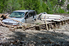
Areas damaged by wildfires are known as burn scars and are particularly susceptible to flash floods and debris flows during rainstorms. Rainfall that is normally absorbed by vegetation can run off almost instantly, causing creeks and drainage areas to flood much earlier and with higher magnitude than normal. NSSL supplied real-time close-up radar mobile radar data during rain events in southern California where the local NWS radar beam is blocked by the terrain. The effort was part of the NOAA/USGS demonstration flash flood and debris flow early warning system to help forecasters improve flash flood and debris flow warnings in areas damaged by wildfires.