

The US Air Force, US Navy, and NOAA participate in a interagency program referred to as the Shared Processing Program (SPP). The term "Shared Processing" has been applied to the sharing of data, products and associated information derived from the polar environmental satellite programs of the DOD's Defense Meteorological Satellite Program (DMSP), and NOAA's Polar Operational Environmental Satellite (POES) program.
NESDIS ingests and makes available a variety of Shared Processing data. Detailed descriptions of the content and format of that data are found below. The image products shown below use data from the last 14 polar orbits of the DMSP satellites, F13, F14 and F15 (which cover a time period of about 24 hours). The areas shaded gray represent either data gaps or indeterminate data. The data gaps (diamond-shaped) result from incomplete satellite coverage, and the indeterminate data (described for each product below) results from the inability to do retrievals over certain surface types.
 Environmental Data Records - EDR Record Format - 260Kb
 Current Water Vapor Products
The water vapor product is a measurement of the water vapor concentration over the oceans. Indeterminate data in the product below usually results from the inability to take accurate measurements from the polar ice caps and areas of rainfall. Regions on display include the Western Hemisphere and the Eastern Hemisphere. This product is updated every four hours.

The current wind speed product is a measurement of the wind speed over the oceans. Indeterminate data in the product below usually results from the inability to take accurate measurements from the polar ice caps and areas of rainfall. Regions on display include the Western Hemisphere and the Eastern Hemisphere. This product is updated every four hours.

The rain rate product is a measurement of the rainfall intensity over the Earth's surface. Indeterminate data can result from the polar ice caps or certain areas in the Sahara desert. Regions on display include the Western Hemisphere and the Eastern Hemisphere. This product is updated every four hours.

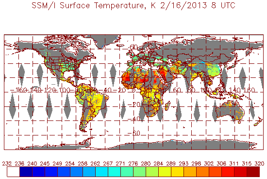
Sample Surface Temperature Product
The surface temperature product measures the temperature at the suface in land regions. Indeterminate data can be a result of snow, ice, and water covered areas, and certain warm regions of the Sahara and Australia. Regions on display include the Western Hemisphere, and the Eastern Hemisphere . This product is updated every 4 hours.
The surface type product describes the environment-type of the land regions. See the legend below for to identify the environment-types. Indeterminate data can be the result of certain warm regions in the Sahara or Australia. Regions on display include the Western Hemisphere, and the Eastern Hemisphere. This product is updated once per day at 4 am EST.


The snow depth product measures the depth of recently accumulated dry snow. Snowfall amounts in excess of 40 cm are considered erroneous. Regions on display include the Western Hemisphere, the Eastern Hemisphere, and North America. This product is updated once per day at 4 am EST.

The soil moisture product gives the percentage of moisture for the land regions. Values in excess of 70 percent are considered erroneous. Regions on display include the Western Hemisphere, the Eastern Hemisphere, and North America. This product is updated once per day at 4 am EST.

Sample Ice Concentration Product
The ice concentration product measures the percentage contcentration of ice over the oceans. Values exceeding 100 percent are considered erroneous. Regions on display include the Western Hemisphere and the Eastern Hemisphere. This product is updated once per day at 4 am EST.

Sensor Data Records - SDR Record Format - 219Kb
Temperature Data Records - TDR Record Format - 715Kb
See the CoastWatch web site.
Go to the Image Products Home Page.
Other Polar Imagery Products:
 Global Vegetation Index Products
AMSU Derived Composite Imagery
Contact Information: |
||
|
You are Here: http://www.osdpd.noaa.gov/ml/spp/sharedprocessing.html
|