Carbon Storage
Geologic Characterization
The process of identifying suitable sites with adequate storage potential involves methodical and careful analysis of the features of promising geologic formations. While geologic formations are infinitely variable in detail, they are classified by geologists and engineers by their trapping mechanism, hydrodynamic conditions, lithology, and, more recently, by their depositional environment. The depositional environment, or the area where sediment was deposited over many years, influences how formation fluids are held in place, how they move, and how they interact with other formation fluids and solids (minerals). Certain geologic properties may be more favorable to the long-term containment of CO2.
Deploying these technologies on a commercial-scale will require geologic storage formations capable of: (1) storing large volumes of CO2; (2) receiving CO2 at an efficient and economic rate of injection; and (3) safely retaining CO2 over extended periods. Eleven major types of depositional environments, each having their own unique opportunities and challenges, are being considered by the U.S. Department of Energy (DOE) for CO2 storage. The different classes of reservoirs reviewed in this study include: deltaic, coal/shale, fluvial, alluvial, strandplain, turbidite, eolian, lacustrine, clastic shelf, carbonate shallow shelf, and reef. Basaltic interflow zones are also being considered as potential reservoirs. For fluid flow in porous media, knowledge of how depositional environments formed and directional tendencies imposed by the depositional environment can influence how fluid flows within these systems and how CO2 in geologic storage would be anticipated to flow in the future.
The efforts of DOE's Regional Carbon Sequestration Partnerships (RCSPs), other large- and small-scale CO2 injection projects, the ARRA Site Characterization projects, and the National Carbon Sequestration Database and Geographic Information System (NATCARB) have substantially increased the knowledge base about the potential to use different geologic formations not previously studied in detail for use in geologic storage of CO2. Yet, in some regions, there is a lack of information on potential storage formations that will require a considerable effort by research organizations, state geologic surveys, and industry to gather existing data and collect new information. This will help to reduce the uncertainty associated with CO2 storage resource estimates, improve our understanding of storage efficiency, and better understand injectivity rates and the performance and extent of regional seals needed to contain CO2. Activities like increased well drilling, long 2-D seismic lines, and digitization of older exploration records are needed to enhance the information available on these high priority geologic basins and storage formations.
|
Graphical Representation of "Project Site Maturation" Through the Exploration Phase of the Site Characterization Process |
|
|
 |
|
| BPM |
|
DOE has prepared a best practices manual (BPM) to establish a framework and methodology for Site Screening, Site Selection, and Initial Characterization of geologic storage sites. This document summarizes the experience gained through DOE's RCSP Initiative during the Characterization and Validation Phases and establishes a consistent industry-standard framework, terminology, and set of guidelines for communicating project related storage resources and risk estimates.
Regional Carbon Sequestration Partnership Characterization Efforts
|
|
| |
 |
| |
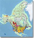
Map depicting the extent of each Regional Carbon Sequestration Partnership Region |
During the Characterization Phase, the RCSPs worked to develop the necessary framework to validate and potentially deploy carbon storage technologies. The main goals of the Characterization Phase were to collect data on CO2 stationary sources, CO2 storage reservoirs, and develop the human capital to support and enable future carbon storage field tests. The RCSPs also sought to evaluate and determine which of the numerous storage approaches are best suited for specific regions of the United States and portions of Canada. The RCSPs succeeded in establishing a national network supporting CCS deployments; created a network of regional carbon storage atlases for the United States (NATCARB), which were used to identify the most promising opportunities; and raised awareness and support for CCS as a greenhouse gas mitigation option.
Currently, the RCSPs are continuing ongoing geologic characterization efforts through their Validation and Development Phase field projects. These field projects efforts are critical in validating and refining current resource estimates for geologic CO2 storage, collecting physical data to confirm CO2 storage potential and injectivity, and developing an improved understanding of the geologic formations within each RCSP region.
NATCARB
NATCARB is a GIS-based tool developed to provide a view of CCS potential and provide all stakeholders with improved online tools for the display and analysis of CCS data, including access to disparate data (CO2 stationary sources, potential geologic CO2 storage, infrastructure, etc.) and analytical tools (pipeline measurement, storage resource estimation, cost estimation, etc.) required for widespread CCS deployment. The data contained with the NATCARB tool has been compiled from the RCSPs, ARRA site characterization projects, industry sources, international sources, and other DOE-funded research efforts.
 |
ARRA Site Characterization Efforts
Using American Recovery and Reinvestiment Act (ARRA) funding, NETL has selected 10 projects to characterize promising geologic formations for CO2 storage that have not been previously investigated. The 10 projects are focusing on the regional characterization of distinct "high-potential" geologic formations that will ultimately provide greater insight into additional types of geologic formations across the United States to safely and permanently store CO2 and further advance DOE efforts to develop a national assessment of CO2 storage capacity in deep geologic formations.

|