
NewsRoom
LabNotes - February 2013
Effect of CO2 on the Integrity of Well Cement under Geologic Storage Conditions
Geologic carbon storage is the separation and capture of carbon dioxide (CO2) from large stationary sources, such as power plants, followed by injection into deep geologic formations. Long-term storage of CO2 pre-supposes very low or no leakage from the formation. The majority of locations that are being considered for CO2 injection are in areas that have a history of oil, natural gas, and/or coalbed methane production, and are typically penetrated by asignificant number of wells from exploration and production. The ability to effectively store large quantities of CO2 may be compromised by the presence of these active or abandoned wells, which represent potential leakage paths.
 |
| Wells are engineered to protect precious groundwater resources, whether for CO2 injection or oil production. Well construction is governed by Federal and state regulations. Three layers of steel (casing and tubing) and two layers of durable, long-lasting cement separate the contents from the surrounding groundwater in this illustration. |
Once an oil or gas well is drilled, it is typically lined with a steel casing cemented into place. The cement is placed in the annular column (the annulus) between the casing and the surrounding rock formation to support the steel casing and to prevent the flow of fluids and gases along its outside diameter. When a well is ultimately abandoned, the casing is typically plugged with cement to block vertical migration of fluids. Cement is not stable in a CO2 environment and can be vulnerable when a wellbore is exposed to CO2 injected into the surrounding formation for permanent storage. The integrity of cement has important implications for the long-term fate of CO2. As a result, NETL research has focused on the integrity of wellbore cement when contacted with injected CO2 under storage conditions. This entails simulating deep underground injection and wellbore conditions such as high temperatures and pressures using common wellbore cements. Results show that temperature, pressure, cement type, cement additives, and fluid properties play a significant role in the rate of reaction and alteration.
Chemical and microstructural changes resulting from exposure to CO2 were examined using a variety of analytical techniques including scanning electron microscopy and x-ray diffraction.
Results of long-term CO2/cement experiments show that the CO2 reaction with typical wellbore cement is too slow to cause leakage in a properly constructed well in good condition, and are in excellent agreement with the examination of cement samples obtained from a well that had been exposed to CO2 for EOR (enhanced oil recovery). However, cement in old or abandoned wells that may have deteriorated could be a problem. As a result, NETL researchers are now studying situations in which gaps or fractures may be present in the cement column.
Co-sequestration, which involves injection of a mixture of CO2 and hydrogen sulfide (acid gas) is increasingly being practiced. For example, there are over 40 wells being used for acid gas injection in Alberta, Canada. In contrast to pure CO2 injection, there is little understanding of the effects of acid gas on exposed wellbore cements under geological storage conditions. Therefore, NETL researchers have initiated studies on the interaction of cement under co-sequestration conditions.
LiDAR Technology Enables the Location of Historic Energy Production Sites
Understanding the impact that newly developed novel methods for extracting resources from the Earth has on our environment is important, but this requires baseline data against which potential changes can be measured. In Pennsylvania, as in other parts of the United States, commercial activity has already left environmental impacts that are not readily discernible.
 |
| Charcoal from a completed burn (image courtesy PA DCNR – Greenwood Furnace State Park). |
An estimated 100,000 abandoned oil and gas wells exist in the United States. Abandoned wells provide potential pathways for methane gas to seep to the surface, where it can trigger explosions, contaminate water supplies, or impact a modern drilling operation. To avoid this, we must characterize future energy production sites. In the past, the National Energy Technology Laboratory (NETL) has successfully used airborne magnetometry to locate abandoned wells.
Another method that may be used to locate abandoned wells is LiDAR, an optical remote sensing technology that can measure the distance to a target via illuminating the target with laser light and analyzing the backscatter. The technology utilizes a narrow laser beam (of ultraviolet, visible, or near infrared light) to create an incredibly high-resolution map of physical features. The data collected using LiDAR can be used to form digital elevation models, detailed topographic maps of the Earth’s surface in open fields and under dense tree canopy. These maps, enhanced through other cartographic techniques, provide an overview of broad, continuous features that may be indistinguishable on the ground.
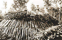 |
| Constructed wood pile ready to burn for charcoal (image courtesy PA DCNR – Greenwood Furnace State Park). |
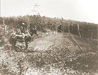
Now, NETL scientists believe that detailed topography could be useful in locating historic oil and gas wells in areas of new gas development in the Marcellus shale. A convenient test area to determine the relative sensitivity of LiDAR data sets was needed. After selecting potential sites, data from the Pennsylvania LiDAR data acquisition program was processed in geographic information system (GIS) software to identify historic energy production sites that are now difficult to locate due to past land use or revegetation. The Greenwood Furnace, a region that produced charcoal between 1834 and 1904, was selected. Charcoal, at that time, was produced in small, flat, cleared areas called hearths. Through the use of LiDAR technology, more than 500 historic charcoal hearths could be identified in a 40-square-mile area surrounding Greenwood Furnace.
 |
| LiDAR shaded relief image at Green Furnace State Park, Pennsylvania, showing locations of historic charcoal hearths. |
NETL used the information collected to refine the LiDAR data processing technique designed to enhance the image quality. This computer model could then be applied to those areas under development in the Marcellus shale to look for the footprint of previous wells. In areas that are continually disturbed by agriculture, surface mining, or urban development, these features may not be visible using LiDAR. Knowing the exact location of these old wells will be important during future preparation and production of unconventional gas wells drilled in the Marcellus shale.
|


