
NOAA Photo and Multimedia Resources
Using NOAA Photos, Videos, and Charts
Most NOAA photos, slides, videos, animations, and charts are in the public domain and CANNOT be copyrighted. When using imagery, credit MUST be given to the National Oceanic and Atmospheric Administration and the Department of Commerce. Where a photographer is noted, please credit the photographer and his/her affiliated organization as well. Additionally, sites listed may contain specific terms of use policies. Please consult these guides to determine limitations on use and distribution of the materials found on each page.
General Sites
NOAA Photo Library
The NOAA Photo Library has been built so as to capture the work, observations, and studies that are carried on by the scientists, engineers, commissioned officers, and administrative personnel that make up this complex and scientifically diverse agency. It also has been built in an attempt to capture NOAA's scientific heritage, which is in fact a heritage shared by much of the physical and environmental science communities in the United States today. To date, over 32,000 images have been digitized and reside in the online NOAA Photo Library. (Photo Credit: Captain Budd Christman, NOAA Corps)
NOAA World Photo and Visualization Collections
A portal page to NOAA photos and visualizations.

NOAA 200th Celebration Photo Contest
To help commemorate NOAA’s 200th anniversary in 2007, NOAA sponsored the NOAA 200th Celebration Photo Contest. The purpose of the contest was to collect images taken throughout NOAA to honor its visual heritage and to expand its image library. All NOAA employees, contractors, and interns were encouraged to submit photos emphasizing the great things that the people at NOAA do and what they encounter.
NOAA Environmental Visualization Laboratory
The National Environmental Visualizaiton laboratory features images and animations created from NOAA satelite data, primarily the GOES and POES spacecraft. Imagery is available in JPG or PNG format in medium or high resolution formats. Animations and Videos are available in MPEG-4 format. (Photo Credit: NOAA Environmental Visualization Laboratory)

NOAA Podcasts
These are short reports on NOAA science and research. They are in mp3 files for easy downloads to desktop and laptops, as well as mobile devices capable of playing these files. You also can listen to these programs by simply clicking on the link.
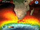
NOAA Geophysical Fluid Dynamics Laboratory Visualizations
The Geophysical Fluid Dynamics Laboratory (GFDL) develops and uses mathematical models and computer simulations to improve our understanding and prediction of the behavior of the atmosphere, the oceans, and climate. (Photo Credit: NOAA GFDL)
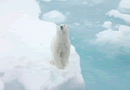
NOAA Arctic Theme Page Photo Gallery
NOAA provides Arctic information and a set of reputable indicators that describe the present state of the Arctic ecosystem and climate, including a robust gallery of photos and webcam animations(Photo Credit: Kathy Crane, NOAA Arctic Research Program)
NOAA Satelites and Information Service Multimedia
The National Environmental Satellite, Data, and Information Service (NESDIS) is dedicated to providing timely access to global environmental data from satellites and other sources to promote, protect, & enhance the Nation's economy, security, environment, & quality of life. They provide a library of videos that educate on the use and utility of satelites by NOAA. (Photo Credit: NOAA NESDIS)

NOAA Research Podcasts
OAA provides environmental services that protect lives, and property, and our data and services contribute to industries that account for a third of the nation"s Gross Domestic Product. NOAA services touch many people every day, and NOAA research is critical to improving those services. Listen in and learn how our scientists are answering some of the important Earth science questions of our time. (NOAA Research)
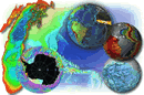
National Geophysical Data Center
The Images offered here were produced in the National Geophysical Data Center's Marine Geology & Geophysics Division (with the exception of the sea floor topography from satellite altimetry images, produced by Dr. Walter Smith of NOAA).(Photo Credit: NOAA NGDC)
Ocean & Coasts
National Ocean Service Multimedia
Including videos, podcasts, images, and games, this multimedia gallery put together by the National Ocean Servce has many useful sources of information for use in an educational setting. (Photo Credit: National Ocean Service)

Ocean Explorer Multimedia Discovery Missions and Multimedia Gallery
The Multimedia Discovery Mission Demos are a series of 15 interactive multimedia presentations and learning activities that address topics ranging from Chemosynthesis and Hydrothermal Vent Life and Deep-sea Benthos to Food, Water and Medicine from the Sea. Additionally, Ocean Explorer's website includes maps, images, podcasts, and videos that represent each exploration. (Photo Credit: Kathy Crane, NOAA Ocean Explorer)

NOAA Coast Watch Image Gallery
NOAA CoastWatch provides a variety of environmental data from several different satelite platforms covering all U.S. coastal waters including Hawaii and Alaska. (Photo Credit: NOAA Coast Watch)
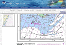
Office of Coast Survey Online Chart Viewer
NOAA’s 1,000-plus U.S. coastal and Great Lakes nautical charts are viewable here on-line. Each chart is up-to-date with the most recent Notices to Mariners corrections. Use these on-line charts as a ready reference or planning tool. (Photo Credit: NOAA Office of Coast Survey)

NOAA Coastal Services Center: Digital Coast
These data sets represent some of the coastal data most requested by Digital Coast partners. Access to data managed by the NOAA Coastal Services Center is provided through the Data Access Viewer, which allows for user-specified geographies, formats, and resolutions. Other data sets are provided through various mechanisms maintained by their agencies of responsibility.(Photo Credit: NOAA CSC)
Climate

ClimateWatch Magazine Images
Images and photos focusing on Climate(Photo Credit: ClimateWatch)

Earth System Research Laboratory Global Systems Division Educational Graphics
Educational graphics for teaching about Global Climate Change and the Greenhouse Effect(Photo Credit: NOAA ESRL)

Paleoclimatology Slidesets
Series of slidesets that provide background on a variety of paleoclimatology subjects, including Ice Ages, Tree Rings, Ice Cores, Coral Reefs and much more.(Photo Credit: NOAA NCDC)
Weather & Atmosphere

National Weather Service Lightning Safety Photo Gallery
A user-generated photo page, the NWS lightning safety photo gallery is an ongoing effort to showcase local weather photos, while educating the public about weather hazards and phenomena. We are currently accepting images of lightning. (Photo Credit: NOAA NWS)
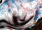
NOAA Space Weather Prediction Center
Collection of images, charts and graphs from various presentations and press briefings from NOAA's Space Weather Prediction Center. (Photo Credit: NOAA Space and Weahter Prediction Center)

NOAA Emergency Response Imagery
The imagery posted on this site was acquired by the NOAA Remote Sensing Division to support NOAA national security and emergency response requirements. In addition, it will be used for ongoing research efforts for testing and developing standards for airborne digital imagery. (Photo Credit: NOAA Emergency Response)

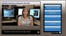
Aircraft Operations Center
The airplanes and helicopters of the Aircraft Operations Center (AOC) are flown in support of NOAA's mission to promote global environmental assessment, prediction and stewardship of the Earth's environment. NOAA's aircraft operate throughout the United States and around the world; over open oceans, mountains, coastal wetlands, and Arctic pack ice. These versatile aircraft provide scientists with airborne platforms necessary to collect the environmental and geographic data essential to their research, including images of the walls of hurricanes taken by "Hurricane Hunters". (Photo Credit: NOAA AOC)

NOAA NESDIS Operational Significant Event Imagery
The Operational Significant Event Imagery team produces high-resolution, detailed imagery of significant environmental events which are visible in remotely-sensed data available at the NOAA Science Center in Suitland, Maryland. (Photo Credit: NOAA NESDIS OSEI)
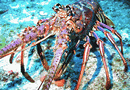
Marine Life

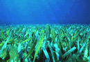
NOAA Coral Reef Conservation Program Multimedia Resources Page
This list of resources is not meant to be comprehensive. Photos and videos viewed at these sites may be subject to copyright. Before downloading ANY of these resources, please note the copyright information and usage rights associated with each resource. Make sure your usage falls within the guidelines provided by each Website and credit entities and individuals, as appropriate.(Photo Credit: Dr. Anthony R. Picciolo, NOAA NODC)

National Marine Sanctuaries Image & Video Galleries
The Media Library is an online vault where a comprehensive collection of select video clips and high-resolution still images from America's underwater treasures are securely stored and available for searchable access and download. (Photo Credit: National Marine Sanctuaries)

Alaska Fisheries Science Center Multimedia Gallery
The Alaska Fisheries Science Center (AFSC) Multimedia Gallery is a collection of select photographs and videos spanning years of AFSC field research on the living marine resources of the North Pacific and Arctic Oceans. (Photo Credit: Alaska Fisheries Science Center)

Papahānaumokuākea Marine National Monument Photos and Videos
The Papahānaumokuākea Marine National Monument is the single largest conservation area under the U.S. flag, and one of the largest marine conservation areas in the world. It encompasses 139,797 square miles of the Pacific Ocean (105,564 square nautical miles) - an area larger than all the country's national parks combined. This page highlights video and images from the monument (Photo Credit: NOAA Office of National Marine Sanctuaries)
Freshwater

EstuaryLIVE
EstuaryLive presents videos, live broadcasts, virtual field-trips, dynamic presentations, and other exciting events in estuarine reserves across the country. (Photo Credit: Estuary.gov)