|
|
|
Metadata
|
|
ID
|
02005
|
|
Also Known As
|
02005
S-1-02-MA
|
|
Abstract
|
United States Geological Survey, Woods Hole, Massachusetts.
Geodetic data (GPS, attitudesensor) of field activity 02005
(S-1-02-MA) in Cape Cod National Seashore, Barnstable,
Massachusetts, United States, North America, North Atlantic
from 01/08/2002 to 01/08/2002
|
|
Organization
|
United States Geological Survey, Woods Hole, Massachusetts
|
|
Project/Theme
|
Large-scale shoreline change
|
|
Activity Type
|
Geodetic
|
|
Platform
|
Swash-I
|
|
Area of Operation
|
Cape Cod National Seashore, Barnstable, Massachusetts, United States, North America, North Atlantic
|
|
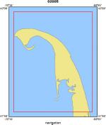
Location map
|
|
|
Bounding Coordinates
|
42.13330
-70.25000 -69.93330
41.83330
|
|
Ports
|
leave Woods Hole, MA
arrive Woods Hole, MA
|
|
Dates
|
01/08/2002 (JD 008) to 01/08/2002 (JD 008)
|
|
Analog Materials
|
No analog holdings.
|
|
Index map

|
|
|
Crew
|
|
Jeff List
|
Chief Scientist, USGS Woods Hole
|
|
Chris Polloni
|
Scientist, USGS Woods Hole
|
|
|
Equipment Used
|
|
|
Purpose
|
|
Shoreline survey within the Cape Cod National Seashore
|
|
|
Notes
|
|
Related web sites: http://woodshole.er.usgs.gov/operations/swash/
|
|
|
Got Help?
|
For 02005, we would appreciate any information on -- analog materials, chief scientist, contract, days at sea, dive count, funding, information specialist, information to be derived, kms of navigation, national plan, NGDC Info, owner, project number, publications, scanned materials, seismic description, station count, station description, submersible, summary, tabulated info.
|
|