Link to USGS home page
USGS Home
Contact USGS
Search USGS
Coastal & Marine Geology InfoBank

USGS CMG B-2-76-NP Metadata

Skip navigational links
Search InfoBank
Home tab FACS tab Activities tab Atlas tab Geology School tab More tab More tab Activities tabs
   
Activities: by ID   by Platform   by Year   by Region   by Participant   by Organization   by Project/Theme   with Incomplete IDs   Disclaimer  
Activity First Letter: A   B   C   D   E   F   G   H   I   J   K   L   M   N   O   P   Q   R   S   T   U   V   W   X   Y   Z   0   1   2   3   4   5   6   7   8   9  
Virtual Globes: Atlas  (GE)    Samples  (GE)    Illuminate Oceans  (GE)    Earthquakes  (GE)    Get GE    InfoBank examples    State Waters
B-2-76-NP links...
Metadata & Data: Bathymetry   Magnetics   Metadata   Navigation   bath (GE GM)   mag (GE GM)   nav (GE GM)   times (GE GM)  
Formal Metadata: Frequently-Anticipated Questions   Outline   Parseable Text   XML  
   
   
Metadata
ID B-2-76-NP
Also Known As 09030039
SI343615
Abstract United States Naval Oceanographic Office. Chief Scientist: Unspecified. Geophysical data (transitsatellite, magnetics, sparker, 3dot5khz, expendablebatthermograph, currentmeter, 12khz) of field activity B-2-76-NP in Pearl Harbor, HI, to Yokosuka, Japan from 04/07/1976 to 04/23/1976
Organization United States Naval Oceanographic Office
Project/Theme Navoceano Deep Ocean Survey
Chief Scientist Unspecified
Activity Type Geophysical
Platform Silas Bent
Area of Operation
Pearl Harbor, HI, to Yokosuka, Japan
Location map B-2-76-NP location map of where navigation equipment operated
Bounding Coordinates 49.99000
142.92166    -161.27000
22.78500
Dates 04/07/1976 (JD 098) to 04/23/1976 (JD 114)
Analog Materials No analog holdings.
Index map

B-2-76-NP map of where navigation equipment operated

Crew
Unspecified Chief Scientist
Equipment Used
transitsatellite
magnetics
sparker
3dot5khz
expendablebatthermograph
currentmeter
12khz
Summary
3.5 khz analog profiles, EDO 240 system, 20 SVSTD stations taken, 17 cores, 163 successful XBT's, 1 current meter array implanted and recovered
Notes
US Naval Oceanographic Office
NGDC Overview
! Converted to time format with year at start.
!
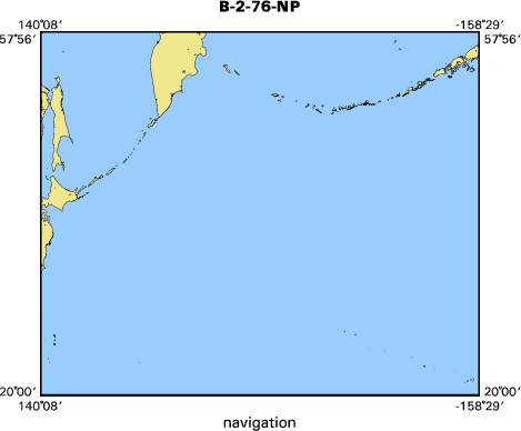
DATA COLLECTION OVERVIEW (use NGDC GEODAS CD to retrieve data)
MCG Data Collection ID --- B176NP
Institution Data Collection ID --- SI343615
NGDC ID --- 09030039
Funding --- NAVOCEANO
Project, Cruise & Leg --- LEG 1
Study region --- +50.00000,+22.00000,+142.00000,-161.00000
Chief Scientist(s) --- NAVOCEANO CODE 3432
Name of vessel --- USNS SILAS BENT (surface ship)
Date field data collection started --- 04/05/76 PEARL HARBOR
Date field data collection ended --- 04/25/75 YOKOSUKA
Parameters surveyed ---
Bathymetry: surveyed, contained in data file
Magnetics: surveyed, contained in data file
Gravity: not surveyed
High-resolution seismics: surveyed, but not contained in data file
Deep penetration seismics: surveyed, but not contained in data file
Format --- (I1,A8,F5.2,4I2,F5.3,F8.5,F9.5,I1,F6.4,F6.1,I2,i1,3F6.1,I1,F5.1,F6.0,F7.1,F6.1,F5.1,A8,4I1)
Date of data input to NGDC --- 08/02/82
Contributing institution --- US NAVAL OCEANOGRAPHIC OFFICE
Country --- USA
Navigation instrumentation --- MX706 SATNAV, SPN38 L/C
Position determination method --- PRIM-SATELLITE
Bathymetry instrumentation --- HARRIS 853-D 2-2/3 BEAM 12KHZ 1-SEC SW
Additional forms of bathymetric data --- ANALOG
General rate of bathymetry in file --- 1.0 minutes
General collection rate of bathymetry --- EVERY 10 SEC
Assumed sound velocity --- 1500.0 m/sec
Bathymetric datum code --- No correction applied (sea level)
Bathmetry interpolation scheme --- DATA AVERAGED TO OBTAIN 1-MINUTE VALUES
Magnetics instrumentation --- PROTON PRECESSION MAG-VARIAN
Additional forms of magnetics data --- ANALOG
General rate of magnetics in file --- 1.0 minutes
General collection rate of magnetics --- 10 seconds
Magnetic sensor tow distance --- 245 meters
Magnetic sensor depth --- (unspecified)
Two sensor horizontal separation --- (unspecified)
Residual magnetics reference field --- IGRF-65
Method of applying residual field --- (unspecified)
Seismic instrumentation --- TELEDYNE 90KJ SPARKER 31-160HZ 1 CHAN
Formats of seismic data --- ANALOG
Notes ---
3.5KHZ ANALOG PROFILES - EDO 240 SYSTEM
20 SVSTD STATIONS TAKEN 17 CORES 163 SUCCESSFUL XBT'S
1 CURRENT METER ARRAY INPLANTED AND RECOVERED
Got Help? For B-2-76-NP, we would appreciate any information on -- analog materials, contract, days at sea, dive count, funding, information specialist, information to be derived, kms of navigation, national plan, owner, ports, project number, publications, purpose, scanned materials, seismic description, station count, station description, submersible, tabulated info.


Skip footer navigational links


InfoBank   Menlo Park & Santa Cruz Centers   St. Petersburg Center   Woods Hole Center   Coastal and Marine Geology Program   Geologic Information   Ask-A-Geologist   USGS Disclaimer  

FirstGov button   Take Pride in America button