
|
|
|
|
Metadata
|
|
ID
|
02024
|
|
Also Known As
|
02024
A-1-02-GK
A102GK
|
|
Abstract
|
University of Rhode Island,United States Geological Survey,
Woods Hole, Massachusetts,National Marine Fisheries Service.
Chief Scientists: Page Valentine, Robert Reid, Jeremy Collie.
Geological data (underwatercamera, pcode, ottertrawl, dredge,
CTDmeter) of field activity 02024 (A-1-02-GK) in Georges
Bank, United States, North America, North Atlantic from
08/19/2002 to 08/30/2002
|
|
Organization
|
University of Rhode Island
United States Geological Survey, Woods Hole, Massachusetts
National Marine Fisheries Service
|
|
Project/Theme
|
Geologic Studies of Benthic Habitats - Georges Bank
|
|
Chief Scientist
|
Page Valentine
Robert Reid
Jeremy Collie
|
|
Activity Type
|
Geological
|
|
Platform
|
Albatross IV
|
|
Area of Operation
|
Georges Bank, United States, North America, North Atlantic
|
|
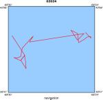
Location map
|
|
|
Bounding Coordinates
|
41.49123
-69.35696 -66.54169
40.44788
|
|
Ports
|
leave Woods Hole, MA
arrive Woods Hole, MA
|
|
Dates
|
08/19/2002 (JD 231) to 08/30/2002 (JD 242)
|
|
Analog Materials
|
No analog holdings.
|
|
Index map

|
|
|
Crew
|
|
Page Valentine
|
Chief Scientist, USGS Woods Hole
|
|
Robert Reid
|
Chief Scientist, NMFS
|
|
Jeremy Collie
|
Chief Scientist, URI
|
|
Dann Blackwood
|
Field Assistant, USGS Woods Hole
|
|
Madhavi Mamidipalli
|
Field Assistant, USGS Woods Hole
|
|
|
Equipment Used
|
|
underwatercamera
|
|
pcode
|
|
ottertrawl
|
|
dredge
|
|
CTDmeter
|
|
|
Purpose
|
|
Habitat mapping and process studies
|
|
|
Got Help?
|
For 02024, we would appreciate any information on -- analog materials, contract, days at sea, dive count, funding, information specialist, information to be derived, kms of navigation, national plan, NGDC Info, notes, owner, project number, publications, scanned materials, seismic description, station count, station description, submersible, summary, tabulated info.
|
|


