Pacific Region Home Page
WFO Honolulu, Hawai`i Home Page
Current Hazards
Hawai`i
- Small Craft Advisory for Maalaea Bay, Pailolo Channel, Alenuihaha Channel, Big Island Leeward Waters, Big Island Southeast Waters now in effect until 6:00 pm Feb 16, 2013
issued: 339 AM THU FEB 14
- Small Craft Advisory for Kauai Northwest Waters, Kauai Windward Waters, Kauai Leeward Waters, Kauai Channel, Oahu Windward Waters, Oahu Leeward Waters, Kaiwi Channel, Maui County Windward Waters, Maui County Leeward Waters, Big Island Windward Waters in effect until starting at 6:00 pm Feb 14, 2013, and lasting until 6:00 pm Feb 16, 2013
issued: 339 AM THU FEB 14
Current Conditions
Observations
- State Weather Roundup and Buoy Reports
- Hawaii Temperature and Precipitation Summary
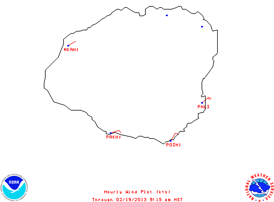
- Hawaii Comprehensive Hourly Wind Data
- Hourly Wind Summary
- Hawai`i Rainfall Summary
- 30 day archive of Hawai`i Rainfall Summary (updated several times daily)
- Daily Hawai`i Cooperative Observations
- 30 day archive of Daily Cooperative Observations
- Statewide Surf Observations
- Kaua`i
- O`ahu
- Moloka`i
- Lana`i
- Maui
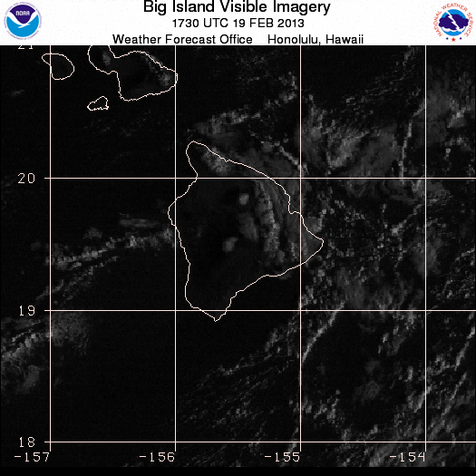
- Big Island of Hawai`i
Sites Across Hawaii (only the past 24 hour observations are available)
- Lihue Airport, Kauai
 
- Kekaha / Barking Sands, Kauai
- Honolulu International, Oahu
- Kaneohe Bay MCAF, Oahu
- Kalaeloa Airport, Oahu
- Wheeler Army Airfield, Oahu
- Kahului Airport, Maui
- Lahaina / West Maui, Maui
- Molokai Airport, Molokai
- Lanai City Airport, Lanai
- Hilo International, Big Island
- Kailua / Kona, Keahole Airport, Big Island
- Bradshaw Army Air Field, Big Island
Other Sites Across the Pacific (only the past 24 hour observations are available)
- Guam Intl Airport(PGUM)
- Midway Island (PMDY)
- Wake Island (PWAK)
- Pago Pago, America Samoa (NSTU)
- Faleolo Intl Airport / Apia, Samoa (NSFA)
- Christmas Island (PLCH)
- Tahiti-Faaa, French Polynesia (NTAA)
- Tarawa, Kiribati
- Kwajalein / Bucholz, Marshall Islands (PKWA)
- Majuro, Marshall Islands (PKMJ)
- WSO Majuro, Marshall Islands (PKMR)
- Kusaie / Kosrae East, Federated States of Micronesia (PTSA)
- Ponape Island, Federated States of Micronesia (PTPN)
- Chuuk Intl Airport, Federated States of Micronesia (PTKK)
- Yap Island, Federated States of Micronesia (PTYA)
- Koror / Palau Island, Palau (PTRO)
Analyses
- Symbols & Test Chart
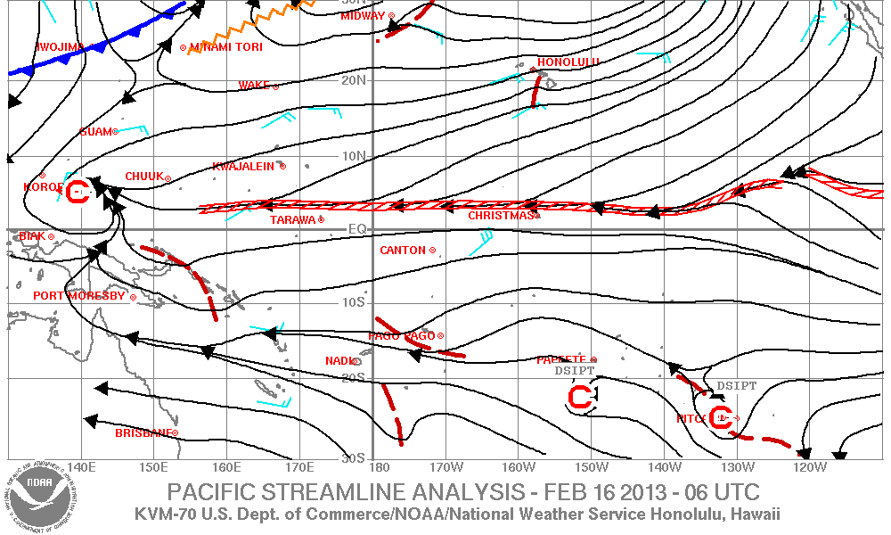
Pacific Streamline Analysis (130E-110W,30S-30N):
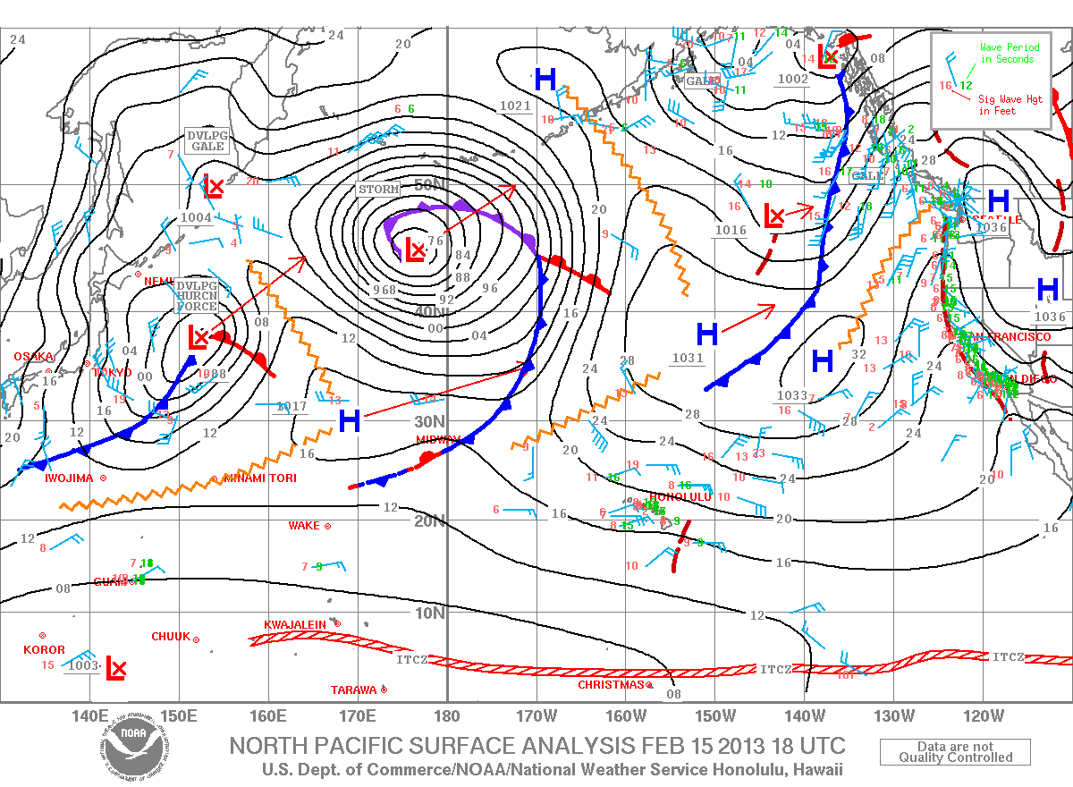
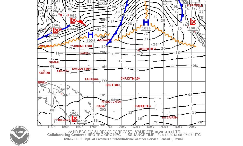
Pacific Surface Forecast (130E-110W,30S-50N)
Sea State Analysis and Forecast
- North Pacific SST Analysis Satellite-derived (updated twice weekly)
Cloud Anaylsis/Nephanalysis (160E-110W, 30S-50N): gif format
- Latest
- 03Z
- 15Z
Forecasts
Aviation
- Graphic Forecasts
- Aviation Area Map
- Graphic of Central and Eastern Pacific SIGMETsfrom the Aviation Weather Center
- TAFs
- Area Forecast for Hawaii and adjacent coastal waters
- 6hr Low Level Wind and Temperature Aloft Forecast for Honolulu, Lanai, Hilo, Lihue, Kahului, and Kona
- 12hr Low Level Wind and Temperature Aloft Forecast for Honolulu, Lanai, Hilo, Lihue, Kahului, and Kona
- 24hr Low Level Wind and Temperature Aloft Forecast for Honolulu, Lanai, Hilo, Lihue, Kahului, and Kona
- 6hr High Level Wind and Temperature Aloft Forecast for Honolulu, Lanai, Hilo, Lihue, Kahului, and Kona
- 12hr High Level Wind and Temperature Aloft Forecast for Honolulu, Lanai, Hilo, Lihue, Kahului, and Kona
- 24hr High Level Wind and Temperature Aloft Forecast for Honolulu, Lanai, Hilo, Lihue, Kahului, and Kona
- FYI/Help for Forecast Winds and Temperatures Aloft
- AIRMETs for IFR conditions, turbulence, and icing
Route Forecasts
- San Francisco/Santa Barbara to Honolulu Route
- National Graphics
- Alaska Aviation Wx
- Aviation Weather Center
Weather Safety
Event Summaries
- Windward Oahu Flash Flood Event - June 4, 2011
- High Winds and Flooding Rains December 10-14, 2008
- High Winds and Flooding Rains December 4-11, 2007
- Hazy Hawaiian Skies due to California Wildfires
- Tsunami November 15, 2006
- Heavy Rainfall - Oct 31 to Nov 2, 2006
- Small Tsunami of May 3, 2006
- Unprecedented Extended Wet Period across Hawaii
- Jan 8-9, 2005 Severe Storms on Kauai and Oahu
- Extreme North Shore Surf - December 15, 2004
- Manoa Valley Flood October 30, 2004
- Darby Rainfall Event August 3-4, 2004
- Heavy Rainfall Events November 29-December 8, 2003.
- Destructive High Surf November 20-23, 2003.
- Lenticular clouds formed near Mauna Loa and Mauna Kea on November 25, 2003. Check out how they form, and some pictures from the event.
- Hurricane Jimena passed to the south of the Hawaiian islands Labor Day weekend 2003.
- StormTsunamiReady
- EMWIN
|


