
Societal Benefits
U.S. IOOS delivers the data and information needed to increase understanding of our coastal waters, so that decision-makers can take action to improve safety, enhance the economy, and protect the environment. U.S. IOOS supplies critical information about our Nation’s waters. Scientists working to understand climate change, governments adapting to changes in the Arctic, municipalities monitoring local water quality, industries understanding coastal and marine spatial planning all have the same need: reliable and timely access to data and information that inform decision making.

Compatible, easily accessible data from multiple sources are increasing understanding of how oceans drive storms to enable earlier, more accurate weather predictions. This allows people to get to safety before disaster strikes.
Predicting Severe Weather
Compatible, easily accessible data from multiple sources are increasing understanding of how oceans drive storms to enable earlier, more accurate weather predictions. This allows people to get to safety before disaster strikes. For example, Northeast fishermen use IOOS weather and water data to make informed decisions about when it is safe to head to sea, while Puerto Rico’s Department of Natural Resources relies on IOOS-derived coastal flooding maps to plan for and respond to hurricane storm surge.
Forecasting Hazards
Integrated ocean data are enhancing scientific ability to forecast environmental changes and hazardous events, so decision makers can take targeted action, such as closing a beach to avoid illnesses caused by blooms of harmful algae. Hourly ocean temperatures, currents, and other data also alert West Coast oyster growers and East Coast shellfish harvesters to conditions that trigger toxic algae outbreaks, which can make shellfish unsafe to eat.

Climate change is impacting our Earth’s surface temperature in ways we are still working to
understand.
Understanding Climate Change
IOOS provides the observing systems to collect data that help produce better and faster forecasts and predictions such as expected sea level rise and hazard warnings for coastal communities. These observing systems provide high-quality data to discern trends and interpret data for predictions needed to determine the extent of climate change now and in the future.
New tools, such as unmanned, underwater gliders, are capable of diving deep through the water column to capture continuous, real-time data at various depths and locations. This new technology enables climate scientists access to large new data sets, helping improve their climate models and allowing scientists to better predict future changes.
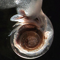
Too much acid in the ocean is bad news for sea life. Acid eats away at calcium carbonate, the primary ingredient of shells and skeletons that many ocean animals depend on for survival. The shell pictured here is a victim of this process. The normally-protective shell is so thin and fragile, it is transparent.
Detecting Ocean Acidification
In the Pacific Northwest, increased monitoring of coastal seawater has helped revived oyster hatcheries on the verge of collapse just a few years ago.
Corrosive acidified seawater, created as the ocean absorbs excess atmospheric carbon dioxide, depletes the ocean of a nutrient vital to building shells. Known as ocean acidification, this process slows growth or even dissolves shells to the point where oyster larvae cannot survive. Currently, ocean chemistry is changing at least 30 times faster than at any time during the 800,000 years prior to the industrial era.
Along the Oregon and Washington coast, ocean observations both detected the acidification that was threatening shellfish and offered an approach to address it. With monitoring revealing water conditions that oysters can and cannot tolerate, commercial oyster hatcheries were able to take actions to avoid poor conditions. For Taylor Shellfish Farms in Washington, 2010 was the best year since 1989. Whiskey Creek Hatchery in Oregon also enjoyed rising productivity, with significant improvements in 2010 from their 2008 productivity.

Surface current data collected using High Frequency Radars is helping aid search and rescue crews by reducing potential search areas.
Improving Search and Rescue Success
IOOS is introducing state-of-the-art technology that enables ocean current tracking in near-real-time, thus aiding search and rescue crews in mapping the probable path of people lost at sea. Knowing how currents will move people or life rafts in the water reduces the area that rescue crews must search for survivors. Combing less area takes less time and increases the chance of saving lives.
Learn about High Frequency Radar and measuring ocean surface currents
Minimizing Rip Current Deaths
Nationally, rip currents cause an estimated 100 deaths per year. IOOS partners in the Caribbean, Carolinas, and Hawaii are working with the National Weather Service and local emergency management officials to increase the number of wave observations and advance wave forecasts to improve warnings and safety alerts.
Monitoring Water Quality
Combined marine data will improve the ability of coastal communities to monitor water quality and protect public health with early warnings. The Great Lakes region puts this effort into action by maintaining and expanding a network of water quality monitoring buoys that report water temperature, conductivity, pH, turbidity, and dissolved oxygen. These data are used to create E. coli predictions for swimming beaches, among other things.
Optimizing Marine Operations
IOOS provides tools mariners can use that are critical to the safe passage of vessels and efficient harbor navigation for port managers and the maritime community. For example, IOOS paired currents data from radar systems with existing wave data into a user-friendly website providing tankers with up-to-date sea conditions as they enter the Port of Long Beach, California, one of our nation’s busiest ports. This information reduces the risk of accidents in such high-traffic areas.
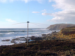
High frequency radar systems, such as the one shown here, are used to measure ocean surface currents and are one component of the Integrated Ocean Observing System.
Enhancing Oil Spill Response
IOOS enables tracking of oil spills and other pollutants so responders can minimize harmful impacts. The explosion onboard the Deepwater Horizon oil rig about 40 miles off the coast of Louisiana in April of 2010, unleashed the largest offshore oil spill in U.S. history. Using new technologies, IOOS partners across the nation captured data to assist in the response. Unmanned, underwater gliders and shore-based radar stations helped locate and track oil at various levels within the water column as well as on the surface. This reduced the need for valuable response resources and improved safety by reducing the number of people sampling from surface vessels. This was the first U.S. oil spill response to apply underwater gliders in the response.
Read More: High Frequency Radars
Predicting Threats to Human Health
Ocean observations are improving scientific ability to detect and mitigate outbreaks of disease and other harmful conditions. For example, researchers recently developed a system for predicting cholera outbreaks using satellite monitoring of marine environments. Data showed that epidemics follow seasonal increases in sea temperatures and phytoplankton levels. The tiny organisms increase in number as water temperatures rise and bring the cholera pathogen to drinking water supplies. This finding could lead to early warnings for similar ocean health threats that are common in the United States.