The National Map
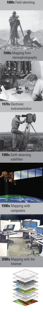 |
125 Years of Topographic MappingThe U.S. Geological Survey is celebrating the 125th anniversary of its national program for topographic mapping (1884–2009). Topographic maps became a signature product of the USGS because the public found them—then and now—to be a versatile tool for viewing our Nation's vast landscape. During the 20th century, more than 55,000 large-scale topographic maps were published by the USGS, culminating in complete coverage of the contiguous 48 States in 1991. In the last quarter-century, the rise of the digital age, the rapid growth of Internet communications, and the technology of geographic information systems (GIS) have transformed topographic mapping science, enabling the electronic construct of The National Map of today. On December 3rd, the USGS observed the 125th anniversary of its topographic maps as well as released two new mapping products at a special event held at the USGS National Center in Reston, Virginia. Videos, Pocasts, pictures, proceedings, and other information products are available at this site. Thank You

A Celebration of 125 Years of Topographic Mapping Thank you for joining us in person or in spirit to celebrate 125 years of USGS topographic mapping. We appreciate your participation, and your enthusiasm for the program of providing topographic information, Internet services, and maps to meet the needs of the Nation. We also look forward to working with many of you as we embark on the next chapter in this endeavor. Please visit the web site for The National Map, explore the new US Topo digital topographic maps and the new viewer for The National Map, and give us your ideas of how we can improve these products and services. Mark DeMulderDirector, National Geospatial Program US Geological Survey Henry Gannett An early American geographer often considered to be the father of American topographic mapping, Henry Gannett (1846–1914) began mapping topography as a member of the Hayden Geological Survey of 1871. Many USGS mapmaking methods and standards were later developed under his leadership, and the USGS Geography Program was established under his direction. While working as a geographer for the U.S. censuses of 1880, 1890, and 1900, and the Philippine, Cuban, and Puerto Rican censuses, Gannett became interested in place names. His efforts to resolve difficulties caused by the confusion of names contributed to the establishment in 1890 of the U.S. Board on Geographic Names. The USGS Henry Gannett Award |

![]() U.S. Department of the Interior |
U.S. Geological Survey
U.S. Department of the Interior |
U.S. Geological Survey
URL: http://nationalmap.gov/125years/index.html
Page Contact Information: The National Map
Page Last Modified: Monday, 14-Jan-2013 17:50:42 EST
