Colorado Plateau
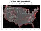
Presented are three 1-D Earth resistivity models based on the magnetotelluric (MT) transect (Ogawa et al., 1996), extending 700 km westward of the Atlantic coast and crossing the Carolinas, Tennessee and Kentucky (Figures 1.1). Locations of the three models were selected to represent several physiographic provinces, specifically the Atlantic Coastal Plain, Piedmonts and the Appalachian Plateau. Models CP-1, PT-1 and AP-1 are situated about 120, 340 and 650 km northwest of the coastline, respectively. (Fernberg et al. 2013, in prep.)
1D Resistivity Model for Colorado Plateau Model CL-1

Resistivity vlaues and depths have been interpreted from published geological reports and maps, and my differ from actual conditions measured by a geophysical survey and/or borehole
Source data: CL-1 Table.docx
Location